
The Main Range is a mountain range and a national park in Queensland, Australia, located predominantly in Tregony, Southern Downs Region 85 kilometres (53 mi) southwest of Brisbane. It is part of the World Heritage Site Gondwana Rainforests of Australia. It protects the western part of a semicircle of mountains in South East Queensland known as the Scenic Rim. This includes the largest area of rainforest in South East Queensland. The park is part of the Scenic Rim Important Bird Area, identified as such by BirdLife International because of its importance in the conservation of several species of threatened birds.

In bioinformatics, a sequence alignment is a way of arranging the sequences of DNA, RNA, or protein to identify regions of similarity that may be a consequence of functional, structural, or evolutionary relationships between the sequences. Aligned sequences of nucleotide or amino acid residues are typically represented as rows within a matrix. Gaps are inserted between the residues so that identical or similar characters are aligned in successive columns.
Sequence alignments are also used for non-biological sequences, such as calculating the edit distance cost between strings in a natural language or in financial data.
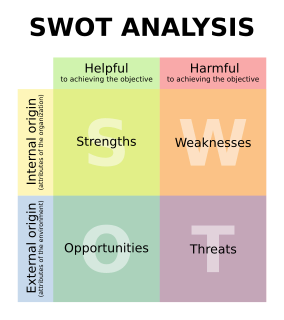
SWOT analysis is a strategic planning technique used to help a person or organization identify strengths, weaknesses, opportunities, and threats related to business competition or project planning. It is intended to specify the objectives of the business venture or project and identify the internal and external factors that are favorable and unfavorable to achieving those objectives. Users of a SWOT analysis often ask and answer questions to generate meaningful information for each category to make the tool useful and identify their competitive advantage. SWOT has been described as the tried-and-true tool of strategic analysis.
Info-gap decision theory is a non-probabilistic decision theory that seeks to optimize robustness to failure – or opportuneness for windfall – under severe uncertainty, in particular applying sensitivity analysis of the stability radius type to perturbations in the value of a given estimate of the parameter of interest. It has some connections with Wald's maximin model; some authors distinguish them, others consider them instances of the same principle.
Organizational network analysis (ONA) is a method for studying communication and socio-technical networks within a formal organization. This technique creates statistical and graphical models of the people, tasks, groups, knowledge and resources of organizational systems. It is based on social network theory and more specifically, dynamic network analysis.
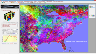
TerrSet is an integrated geographic information system (GIS) and remote sensing software developed by Clark Labs at Clark University for the analysis and display of digital geospatial information. TerrSet is a PC grid-based system that offers tools for researchers and scientists engaged in analyzing earth system dynamics for effective and responsible decision making for environmental management, sustainable resource development and equitable resource allocation.
Apache Cordova is a mobile application development framework originally created by Nitobi. Adobe Systems purchased Nitobi in 2011, rebranded it as PhoneGap, and later released an open source version of the software called Apache Cordova. Apache Cordova enables software programmers to build applications for mobile devices using CSS3, HTML5, and JavaScript instead of relying on platform-specific APIs like those in Android, iOS, or Windows Phone. It enables wrapping up of CSS, HTML, and JavaScript code depending upon the platform of the device. It extends the features of HTML and JavaScript to work with the device. The resulting applications are hybrid, meaning that they are neither truly native mobile application nor purely Web-based. Mixing native and hybrid code snippets has been possible since version 1.9.
Retail leakage occurs when local people spend a larger amount of money on goods than local businesses report in sales, usually due to people traveling to a neighboring town to buy goods. Retail sales leakage occurs when there is unsatisfied demand within the trading area and that the locality should provide extra stores spaces for such type of businesses. After all, retail leakage does not necessarily translate into opportunity. For instance, there could be a tough competition in a nearby locality that leads the market for same type of product. Many small - to medium-sized communities experience leakage of retail expenditures as local citizens drive to neighboring towns to shop at national retail chains or eat at national restaurant chains. Attracting such national retail chain stores and restaurants to a community can prevent this type of expenditure leakage and create local jobs.

Heritage science is cross-disciplinary scientific research to improve the understanding of, engagement with and management of cultural heritage.
The Key Biodiversity Areas (KBA) approach helps to identify and designate areas of international importance in terms of biodiversity conservation using globally standardised criteria. KBAs extend the Important Bird Area (IBA) concept to other taxonomic groups and are now being identified in many parts of the world, by a range of organisations. Examples include Important Plant Areas (IPAs), Ecologically and Biologically Significant Areas (EBSAs) in the High Seas, Alliance for Zero Extinction (AZE) sites, Prime Butterfly Areas, Important Mammal Areas and Important Sites for Freshwater Biodiversity, with prototype criteria developed for freshwater molluscs and fish and for marine systems. The determination of KBAs often brings sites onto the conservation agenda that hadn't previously been identified as needing protection due to the nature of the two non-exclusive criteria used to determine them; vulnerability; and irreplaceability
In fisheries and conservation biology, the catch per unit effort (CPUE) is an indirect measure of the abundance of a target species. Changes in the catch per unit effort are inferred to signify changes to the target species' true abundance. A decreasing CPUE indicates overexploitation, while an unchanging CPUE indicates sustainable harvesting.
The Walter's duiker is a species of duiker found in Togo, Benin and Nigeria. It was described in 2010. Its name commemorates Professor Walter Verheyen, who was the first to obtain a specimen of this species of duiker from Togo in 1968.

Butcher Gap Conservation Park is a protected area located in the Limestone Coast of South Australia overlooking Lacepede Bay about 6 kilometres south of the town of Kingston SE. The conservation park was proclaimed under the National Parks and Wildlife Act 1972 in 1990.
The radiography of cultural objects is the use of radiography to understand intrinsic details about objects. This process can reveal various details about objects that are not visible to the naked eye. This information, which includes structural elements, aids conservators as they assess object condition and consider treatment plans. Radiography can also reveal previous compositions and earlier repairs.
Clements Gap Conservation Park is a protected area located in the Mid North of South Australia about 15 kilometres (9.3 mi) west of Redhill, 20 kilometres (12 mi) north east of Port Broughton and 42 metres above sea level. The park preserves an area of natural bushland and the built remnants of a small historic agricultural township, Clements Gap, about 12 kilometres (7.5 mi) east of the Spencer Gulf coast. Maintained by the South Australian Department of Environment, Water and Natural Resources (DEWNR), the park is classified as an IUCN Category III Natural Monument or Feature. The park is named for the surrounding farming locality of Clements Gap, a reference to the co-located pass through the Barunga Range. The Clements Gap pass in turn is thought to be named after a shepherd in the area prior to 1880, per research by local historian Rodney Cockburn.
Non-coding RNAs have been discovered using both experimental and bioinformatic approaches. Bioinformatic approaches can be divided into three main categories. The first involves homology search, although these techniques are by definition unable to find new classes of ncRNAs. The second category includes algorithms designed to discover specific types of ncRNAs that have similar properties. Finally, some discovery methods are based on very general properties of RNA, and are thus able to discover entirely new kinds of ncRNAs.
The Landscape Conservation Cooperatives (LCC) are a network of 22 regional conservation bodies covering the entire United States and adjacent areas, established in 2009. They are autonomous cooperatives sponsored by the U.S. Department of the Interior, and aim to develop coordinated conservation strategies applicable to large landscape areas. Partnerships are formed with governmental and non-governmental conservation organisations. Similar initiatives have been started or advocated in other parts of the world.