
Tunisia is a country in Northern Africa, bordering the Mediterranean Sea, having a western border with Algeria (965 km) and south-eastern border with Libya (459 km) where the width of land tapers to the south-west into the Sahara. The country has north, east and complex east-to-north coasts including the curved Gulf of Gabès, which forms the western part of Africa's Gulf of Sidra. Most of this greater gulf forms the main coast of Libya including the city of Sirte which shares its root name. The country's geographic coordinates are 34°00′N9°00′E. Tunisia occupies an area of 163,610 square kilometres, of which 8,250 are water. The principal and reliable rivers rise in the north of the country with a few notable exceptions from north-east Algeria and flow through the northern plain where sufficient rainfall supports diverse plant cover and irrigated agriculture.

The geography of Malta is dominated by water. Malta is an archipelago of coralline limestone, located in the Mediterranean Sea, 81 kilometres south of Sicily, Italy, and nearly 300 km north (Libya) and northeast (Tunisia) of Africa. Although Malta is situated in Southern Europe, it is located farther south than Tunis, capital of Tunisia, Algiers, capital of Algeria, Tangier in Morocco and also Aleppo in Syria, and Mosul in Iraq in the Middle East. Only the three largest islands – Malta, Gozo and Comino – are inhabited. Other (uninhabited) islands are: Cominotto, Filfla and the St.Paul's Islands. The country is approximately 316 km2 in area. Numerous bays along the indented coastline of the islands provide harbours. The landscape of the islands is characterised by high hills with terraced fields. The highest point, at 253 metres, Ta' Zuta on mainland Malta. The capital is Valletta.

The Tunisian Sahel or more precisely the Central East Tunisia Region is an area of Central eastern Tunisia and a one of the Six Tunisian Regions. It stretches along the eastern shore, from Hammamet in the north to Mahdia in the south, including the governorates of Monastir, Mahdia, Sfax, and Sousse. Its name derives from the Arabic word sāḥil (ساحل), meaning "shore" or "coast". The regions' economy is based especially on tourism and it contains the second biggest airport in Tunisia: Monastir Habib Bourguiba International Airport.
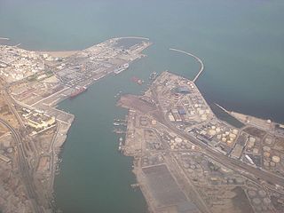
Radès is a harbour city in Ben Arous Governorate, Tunisia. Situated 9 kilometers south-east of the capital Tunis, some consider it a Tunis suburb, and parts of the harbor installations of Tunis are located in Radès.

M'saken is a town in north-eastern Tunisia, close to Sousse.
Gara Isa Khan is a town and union council of Dera Ismail Khan District in Khyber Pakhtunkhwa province of Pakistan. It has an altitude of 186 metres.
Menzel Jemil is a coastal town and municipality in north-eastern Tunisia, 60 km north of the capital, Tunis. Administratively it is located in the Menzel Jemil Delegation of the Bizerte Governorate. Geographically Menzel Jemil is located on the east side of the Bizerte Lagoon and it is now considered part of the city of Bizerte metropolitan area. The municipality had 41,343 inhabitants.
Runówko is a village in the administrative district of Gmina Wągrowiec, within Wągrowiec County, Greater Poland Voivodeship, in west-central Poland.
Çatak Dam is a dam in Kastamonu Province, Turkey, built between 1990 and 1993. The development was backed by the Turkish State Hydraulic Works.
Ouled Chamekh is a town and commune in the Mahdia Governorate, Tunisia. As of 2004 it had a population of 5,093.
Sidi Ali Ben Aoun is a town and commune in the Sidi Bou Zid Governorate, Tunisia. As of 2004 it had a population of 7,403.
Sidi Bou Ali is a town and commune in the Sousse Governorate, Tunisia. As of 2004 it had a population of 9,011.
Bir Mcherga is a town and commune in the Zaghouan Governorate, Tunisia. As of 2004 it had a population of 7,203.

Ben S'Rour District is a district of M'Sila Province, Algeria.

Sidi M'Hamed Ben Ali District is a district of Relizane Province, Algeria.
Sidi M'hamed Ben Ali is a town and commune in Relizane Province, Algeria.
The Kingdom of Tunisia was a short-lived kingdom established on 20 March 1956 after the Tunisian independence and lasted until the declaration of the republic on 25 July 1957.

Tunisia competed at the 2012 Summer Paralympics in London, United Kingdom from August 29 to September 9, 2012. This was the nation's seventh appearance at the Summer Paralympics since 1988. The Tunisian Paralympic Committee sent a total of 31 athletes to the Games, 18 men and 13 women to compete in Athletics only.
Oued Jeneien is a wadi of Taţāwīn, Tunisia. It is also known as Wādī al Janā’in, and Oued Djeneien. in the far south of the country.

