
Dubuque is a city in and the county seat of Dubuque County, Iowa, United States, located along the Mississippi River. At the time of the 2020 census, the population of Dubuque was 59,667. The city lies at the junction of Iowa, Illinois, and Wisconsin, a region locally known as the Tri-State Area. It serves as the main commercial, industrial, educational, and cultural center for the area. Geographically, it is part of the Driftless Area, a portion of North America that escaped all three phases of the Wisconsin Glaciation.

Harrisville is a town in Cheshire County, New Hampshire, United States. Besides the town center, it also includes the villages of Chesham and Eastview. The population of the town was 984 at the 2020 census.
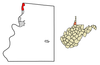
Benwood is a city in Marshall County, West Virginia, United States, along the Ohio River. It is part of the Wheeling, West Virginia Metropolitan Statistical Area. The population was 1,269 at the 2020 census.

Blantyre is Malawi's centre of finance and commerce, and its second largest city, with a population of 800,264 as of 2018. It is sometimes referred to as the commercial and industrial capital of Malawi as opposed to the political capital, Lilongwe. It is the capital of the country's Southern Region as well as the Blantyre District.

Nyarubuye is a sector (imirenge) of the Kirehe District, Eastern Province in Rwanda. Its area is 85.91 km2, and its population in 2022 was 22,660.

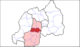
Eastern Province is the largest, the most populous and the least densely populated of Rwanda's five provinces. It was created in early January 2006 as part of a government decentralization program that re-organized the country's local government structures.
Nyagatare is a town in the North East of Rwanda. With a population of more than 100,000, it is one of the most populous settlements in the Eastern Province along with Rwamagana and Kibungo.
The five provinces of Rwanda are divided into 30 districts. Each district is in turn divided into sectors, which are in turn divided into cells, which are in turn divided into villages.
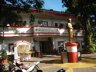
Barangay Poblacion Kadingilan is a primarily agricultural barangay of the Philippine municipality of Kadingilan in the province of Bukidnon on the island of Mindanao.
Bagong Silangan is a barangay located in the 2nd district of Quezon City, Philippines. Nearby barangays are Commonwealth, Batasan Hills and Payatas. Separated by a river in the east, the barangay leads to the Municipality of San Mateo in the province of Rizal.

Nyagatare is the largest and second most populous district (akarere) in Rwanda. Located in Eastern Province, Rwanda, it occupies the northeastern extremity of Rwanda. Its capital is Nyagatare City, the former capital of the now defunct Umutara province. Nyagatare District borders Uganda in the North, Tanzania in the East, Gatsibo District of the in the South, and Gicumbi District of the Northern Province in the West. Nyagatare has an area of 1741 km2, what makes it the largest district in Rwanda. With a population of 466,944 in 2012, and 653,861 in 2022, Nyagatare is the second most populated district of Rwanda only after Gasabo District of Kigali City with 879,505 inhabitants. This is a 156% increase from 2002 when the population was only 255,104. This sharp rise in the population is mainly due to the major movement of the population from other parts of the country in search of land.

Muhanga is a district (akarere) in Rwanda. It is found in southern province and its administrative centre is located in the city of Muhanga.
Ruhango is a district (akarere) in Southern Province, Rwanda. Its capital is Ruhango town, a large settlement on the road between Gitarama and Butare.

Rutsiro is a district (akarere) in Western Province, Rwanda. Its headquarter is located in Gihango sector.

Gatsibo is a district (akarere) in Eastern Province, Rwanda. Its capital is Kabarore. It lies in the sectors of Gatsibo and Kageyo. It’s at about 1 hour and 50 minutes drive from Kigali city.

Nyamata is a town and sector in the Bugesera District, southeastern Rwanda. Nyamata literally means 'place of milk' from the two Kinyarwanda words nya- 'of' and amata 'milk'. It is the location of the Nyamata Genocide Memorial, commemorating the Rwandan genocide of 1994.
Kabarore is a town and sector in Rwanda. It is the headquarters of Gatsibo District.
Kagitumba is a town in Rwanda. It is located at the extreme North Eastern extremity at the confluence of the Kagitumba River and Akagera River. This location is also the tri-point border between Rwanda, Uganda and Tanzania.
University of Rwanda is a public collegiate, multi campus university based in Kigali, Rwanda. Formed in 2013 through the merger of previously independent education institutions, the University of Rwanda is the largest education institution in Rwanda. The University of Rwanda is ranked number one in the country by the Higher Education Council, an organ established by the Government of Rwanda.


