External links
- Geospatial Research Centre (company website)
| This New Zealand corporation or company article is a stub. You can help Wikipedia by expanding it. |
The Geospatial Research Centre (NZ) Ltd. is a consultancy company based in Christchurch, New Zealand in the University of Canterbury's Engineering department. It was set up in 2006 by the University of Canterbury, the University of Nottingham, and the Canterbury Development Corporation. The director is Dr David Park. Their research focuses on civilian uses of Unmanned Aerial Vehicles, and on remote sensing and sensor integration.
| This New Zealand corporation or company article is a stub. You can help Wikipedia by expanding it. |

The University of Canterbury is New Zealand's second oldest university.
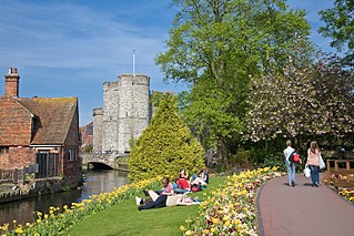
Canterbury is a cathedral city and UNESCO World Heritage Site, situated in the heart of the City of Canterbury, a local government district of Kent, England. It lies on the River Stour.

The University of Kent is a semi-collegiate public research university based in Kent, United Kingdom. The University was granted its Royal Charter on 4th January 1965 and the following year Princess Marina, Duchess of Kent was formally installed as the first Chancellor.

Public sector organisations in New Zealand comprise the state sector organisations plus those of local government.

Geomatics is defined in the ISO/TC 211 series of standards as the "discipline concerned with the collection, distribution, storage, analysis, processing, presentation of geographic data or geographic information". Under another definition, it "consists of products, services and tools involved in the collection, integration and management of geographic data". It includes geomatics engineering and is related to geospatial science.

Christchurch is the largest city in the South Island of New Zealand and the seat of the Canterbury Region. The Christchurch urban area lies on the South Island's east coast, just north of Banks Peninsula. The urban area is home to 383,200 residents, and the territorial authority has 394,700 people, which makes it the second-most populous city in New Zealand after Auckland and before Wellington. The Avon River flows through the centre of the city, with an urban park located along its banks.
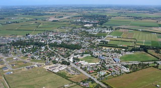
Lincoln is a town in the Selwyn District, in the Canterbury Region of New Zealand's South Island. The town is located on the Canterbury Plains to the west of Banks Peninsula, 22 kilometres southwest of Christchurch. The town has a population of 8,130, making it the second largest town in the Selwyn District behind nearby Rolleston.
The University for the Creative Arts is a specialist art and design university in the south of England.
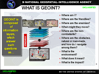
In the United States, geospatial intelligence (GEOINT) is intelligence about the human activity on earth derived from the exploitation and analysis of imagery and geospatial information that describes, assesses, and visually depicts physical features and geographically referenced activities on the Earth. GEOINT, as defined in US Code, consists of imagery, imagery intelligence (IMINT) and geospatial information.
Simon Langton Grammar School for Boys is an 11–18 foundation grammar school for boys and mixed sixth form in Canterbury, Kent, England. It was established in 1881.
Cass is a locality in the Selwyn District of the Canterbury region in New Zealand's South Island.

The NZi3 Innovation Institute is a partnership between the New Zealand government and the University of Canterbury. It was formed in 2006 to commercialise the University's IT research and to develop high-tech industry in Canterbury. A large eco-friendly office building in the university grounds was completed early 2009.
The RMIT School of Mathematical and Geospatial Science was an Australian tertiary education school located within the College of Science Engineering and Health of RMIT University. Since September 2016 the former school has become part of the new RMIT School of Science. Both Mathematical Sciences and Geospatial Science have transitioned into two of the seven distinct disciplines that make up the RMIT School of Science. The last Head of School was Professor John Hearne.

Canterbury Christ Church University (CCCU) is a public university located in Canterbury, Kent, England. Founded as a Church of England college for teacher training in 1962, it was granted university status in 2005.

Kent Business School, also known as KBS, is the business school of the University of Kent. Since opening in 1988, it offers undergraduate, postgraduate, PhD degree programmes and The Kent MBA.

The Army Geospatial Information Center is the military geographical, cartographical and geospatial intelligence agency of the Portuguese Army.
Robin Wayne Carrell is a New Zealand-born haematologist.
The Australasian Virtual Herbarium (AVH) is an online resource that allows access to plant specimen data held by various Australian and New Zealand herbaria. It is part of the Atlas of Living Australia (ALA), and was formed by the amalgamation of Australia's Virtual Herbarium and NZ Virtual Herbarium. As of 12 August 2014, more than five million specimens of the 8 million and upwards specimens available from participating institutions have been databased.
Sisi Zlatanova is a Bulgarian/Dutch researcher in geospatial data, geographic information systems, and 3D modeling. She works as a professor in the faculty of the Built Environment, at the University of New South Wales (UNSW), and is president of Technical Commission IV (Spatial Information Science) of the International Society for Photogrammetry and Remote Sensing.
Suren Raghavan is a Sri Lankan Tamil academic and former Governor of the Northern Province.