
Shooter's Hill is a district of South East London, England, in the Royal Borough of Greenwich bordering the London Borough of Bexley. It lies north of Eltham and south of Woolwich. With a height of 132 metres (433 ft), it is the highest point in the Borough of Greenwich and one of the highest points in London. Shooter's Hill also gives its name to the road which passes through east to west, part of the A207 road, the A2 road and Watling Street.
Gibbeting is the use of a gallows-type structure from which the dead or dying bodies of criminals were hanged on public display to deter other existing or potential criminals. Occasionally, the gibbet was also used as a method of public execution, with the criminal being left to die of exposure, thirst and/or starvation. The practice of placing a criminal on display within a gibbet is also called "hanging in chains".

Perth is a town in the Australian state of Tasmania. It lies 20 km (12 mi) south of Launceston, on the Midland Highway. The town had a population of 3,233 at the 2021 census, and is part of the Northern Midlands Council.
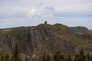
Signal Hill is a hill which overlooks the harbour and city of St. John's, Newfoundland and Labrador, Canada. The majority of Signal Hill, including Cabot Tower, is designated a National Historic Site. The highest point, Ladies' Lookout, is 167 m (548 ft) high.

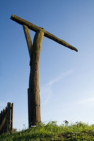
Combe is a village and civil parish in the English county of Berkshire. The parish is situated on the top of the North Hampshire Downs near Walbury Hill and Combe Gibbet, overlooking the village of Inkpen and the valley of the River Kennet. In Walbury Hill, it includes the highest natural point in South East England.
Horns or The Horns may refer to:

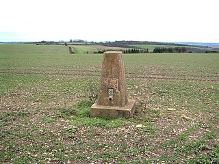
Walbury Hill is a summit of the North Wessex Downs in Berkshire, England. With an elevation of 297 metres (974 ft), it is the highest natural point in South East England. On the hill's summit is the Iron Age hill fort of Walbury Camp, whilst the flanks of the hill lie within the Inkpen and Walbury Hills SSSI. The hill is one of three nationally important chalk wild grasslands in the North Wessex Downs, the others being in the Rushmore and Conholt Downs SSSI and the Hog's Hole SSSI. The summit of the hill is marked by a triangulation pillar, but lies on private land with no public access, although public access is available to the north of the summit via a byway.

The Surrey Hills National Landscape is a 422 km2 (163 sq mi) National Landscape in Surrey, England. It comprises around one quarter of the land area of the county and principally covers parts of the North Downs and Greensand Ridge. It was designated as an Area of Outstanding Natural Beauty in May 1958 and was redesignated as a National Landscape in 2023. The Surrey Hills National Landscape borders the Kent Downs AONB to the east and the South Downs National Park to the south west.
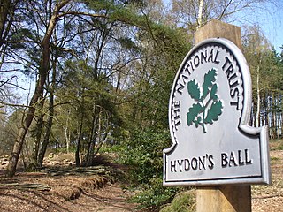
Hydon's Ball is a 179-metre-high (587 ft) hill covering most of Hydon Heath in Hydestile, Surrey, England.
A burrow is a hole made by an animal.
Three Brothers may refer to:

Gibbet Hill is the location of, and name for, the University of Warwick's southern campus, in the south of Coventry, England.
Gallows Hill may refer to:
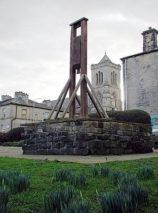
The Halifax Gibbet was an early guillotine used in the town of Halifax, West Yorkshire, England. Estimated to have been installed during the 16th century, it was used as an alternative to beheading by axe or sword. Halifax was once part of the Manor of Wakefield, where ancient custom and law gave the Lord of the Manor the authority to execute summarily by decapitation any thief caught with stolen goods to the value of 131⁄2d or more, or who confessed to having stolen goods of at least that value. Decapitation was a fairly common method of execution in England, but Halifax was unusual in two respects: it employed a guillotine-like machine that appears to have been unique in the country, and it continued to decapitate petty criminals until the mid-17th century.

Puttenham and Crooksbury Commons is a 113.8-hectare (281-acre) biological Site of Special Scientific Interest between Farnham and Guildford in Surrey. Puttenham Common is owned by the Hampton Estate and managed on behalf of Surrey County Council. Hillbury Hillfort on Puttenham Common is a scheduled monument. It is a univallate hillfort which probably dates to the Iron Age.

Gibbet Hill, at Hindhead, Surrey, is the apex of the scarp surrounding the Devil's Punch Bowl, not far from the A3 London to Portsmouth road in England. The road used to pass close to Gibbet Hill, but has now been superseded by the Hindhead Tunnel and the road returned to nature.
Gibbet Mill may refer to a number of windmills:
Inkpen Hill is a summit in Berkshire, England, with a maximum elevation of 291 m (955 ft). The hill is about 7 miles (11 km) southwest of Newbury on the Hampshire/Berkshire border and is part of the north-facing scarp of the North Hampshire Downs, a chalk ridge within the North Wessex Downs Area of Outstanding Natural Beauty. It lies between Walbury Hill, the county top of Berkshire, to the east and Ham Hill to the west. Parts of the hill lie within the Inkpen and Walbury Hills SSSI.
Holmbury Hill is a wooded area of 261 metres (856 ft) above sea level in Surrey, England, and the site of an Iron Age-period hillfort. The Old Saxon word "holm" can be translated as hill and "bury" means fortified place. It sits along the undulating Greensand Ridge, its summit being 805 feet (245 m) from the elevated and tightly clustered small village of Holmbury St. Mary which was traditionally part of Shere, 8 kilometres (5.0 mi) away.