External links
52°15′0″N12°37′0″E / 52.25000°N 12.61667°E
| | This Brandenburg location article is a stub. You can help Wikipedia by expanding it. |
Golzower Busch is a forest in the south of the territory of Golzow in the county of Potsdam-Mittelmark in the German state of Brandenburg. It extends from the B 102 federal highway in the northwest, running towards the southeast for about four kilometres. Its maximum width is one kilometre.
52°15′0″N12°37′0″E / 52.25000°N 12.61667°E
| | This Brandenburg location article is a stub. You can help Wikipedia by expanding it. |

Cambridge is a home rule-class city in Jefferson County, Kentucky, United States. The population was 175 at the 2010 census.

Néma is a town in southeastern Mauritania, close to the border with Mali. It is located at around 16°37′0″N7°15′0″W at the eastern end of the Aoukar. It is the capital of Hodh Ech Chargui Region and of the Néma Department.

Ayoun al Atrous is a town in southern Mauritania. It is located at around 16°40′0″N9°37′0″W. It is the capital of Hodh El Gharbi region. The city is served by the Aioun el Atrouss Airport, 6 kilometres (4 mi) north-west of the city. The town is located in the southern area of the Aoukar, a former lake basin.
This is a list of the extreme points on land of Estonia: the points that are farther north, south, east or west than any other location.

The Knik Glacier is an ice field located 50 miles (80 km) east of Anchorage, Alaska on the northern end of the Chugach Mountains. The ice field averages over 25 miles (40 km) long and over 5 miles (8.0 km) across, making it one of the largest glaciers in southcentral Alaska. Knik Glacier feeds the 25-mile (40 km) long Knik River which empties into the Knik Arm section of Cook Inlet.

The Cayemites are a pair of islands located in the Gulf of Gonâve off the coast of southwest Haiti. The two islands, known individually as Grande Cayemite and Petite Cayemite, are a combined 45 square kilometres (17 sq mi) in area. Petite Cayemite lies just west of the larger island, Grande Cayemite. The islands are approximately 35 kilometres (22 mi) east of the city of Jérémie and are in the administrative department of Grand'Anse.
The Lytton First Nation, a First Nations band government, has its headquarters at Lytton in the Fraser Canyon region of the Canadian province of British Columbia. While it is the largest of all Nlaka'pamux bands, unlike all other governments of the Nlaka'pamux (Thompson) people, it is not a member of any of the three Nlaka'pamux tribal councils, which are the Nicola Tribal Association, the Fraser Canyon Indian Administration and the Nlaka'pamux Nation Tribal Council.
The Troy Junction–Merrygoen railway line is a railway line in northern New South Wales, Australia. It forms part of a cross country railway line between Dubbo in the state's Central West, and Werris Creek on the Main North line, allowing goods from the west of the state to access the Hunter ports, bypassing Sydney.
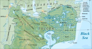
The Sfântu Gheorghe branch is a distributary of the river Danube, that contributes in forming the Danube Delta.
Hagwilget Canyon is a canyon on the Bulkley River of northwestern British Columbia, Canada, located several kilometres upstream from that river's confluence with the Skeena River at Hazelton, at the Wet'suwet'en village of Hagwilget.
Kaczkowizna is a village in the administrative district of Gmina Żychlin, within Kutno County, Łódź Voivodeship, in central Poland. It lies approximately 8 kilometres (5 mi) east of Żychlin, 26 km (16 mi) east of Kutno, and 56 km (35 mi) north of the regional capital Łódź.
Kolonia Dębniak is a village in the administrative district of Gmina Ujazd, within Tomaszów Mazowiecki County, Łódź Voivodeship, in central Poland. It lies approximately 17 kilometres (11 mi) north-west of Tomaszów Mazowiecki and 33 km (21 mi) south-east of the regional capital Łódź.
Zbigniewice-Kolonia is a village in the administrative district of Gmina Koprzywnica, within Sandomierz County, Świętokrzyskie Voivodeship, in south-central Poland. It lies approximately 7 kilometres (4 mi) north-west of Koprzywnica, 19 km (12 mi) south-west of Sandomierz, and 70 km (43 mi) south-east of the regional capital Kielce.
Kępa Nagnajewska is a village in the administrative district of Gmina Łoniów, within Sandomierz County, Świętokrzyskie Voivodeship, in south-central Poland. It lies approximately 8 kilometres (5 mi) south-east of Łoniów, 20 km (12 mi) south-west of Sandomierz, and 81 km (50 mi) south-east of the regional capital Kielce.
Janisławiec is a village in the administrative district of Gmina Nowa Wieś Lęborska, within Lębork County, Pomeranian Voivodeship, in northern Poland. It lies approximately 7 kilometres (4 mi) north of Nowa Wieś Lęborska, 9 km (6 mi) north-west of Lębork, and 67 km (42 mi) north-west of the regional capital Gdańsk.

Wędkowy is a village in the administrative district of Gmina Tczew, within Tczew County, Pomeranian Voivodeship, in northern Poland. It lies approximately 9 kilometres (6 mi) south-west of Tczew and 35 km (22 mi) south of the regional capital Gdańsk.
Lubowo is a village in the administrative district of Gmina Bobolice, within Koszalin County, West Pomeranian Voivodeship, in north-western Poland. It lies approximately 12 kilometres (7 mi) north of Bobolice, 32 km (20 mi) south-east of Koszalin, and 152 km (94 mi) north-east of the regional capital Szczecin.
Ngovayang is an iron ore mining site in the department of Océan, South Region, Cameroon. It is controlled by the Indian company Jindal Steel and Power.
Bugueño Pinnacle is a slender rock peak that is reported to rise over 4400 m between Mount Rutford and Rada Peak on the crest of the Craddock Massif in the Sentinel Range. Named by the Advisory Committee on Antarctic Names in 2006 after Manuel Bugueño, a Chilean member of the Omega High Antarctic GPS Expedition to the Sentinel Range in 2005. He made ascents of Mount Craddock and Rada Peak and, with Camilo Rada, ran the GPS measurements of both.