
The Mississippi River is the second-longest river and chief river of the second-largest drainage system on the North American continent, second only to the Hudson Bay drainage system. Its source is Lake Itasca in northern Minnesota and it flows generally south for 2,320 miles (3,730 km) to the Mississippi River Delta in the Gulf of Mexico. With its many tributaries, the Mississippi's watershed drains all or parts of 32 U.S. states and two Canadian provinces between the Rocky and Appalachian mountains. The main stem is entirely within the United States; the total drainage basin is 1,151,000 sq mi (2,980,000 km2), of which only about one percent is in Canada. The Mississippi ranks as the fourth-longest and fifteenth-largest river by discharge in the world. The river either borders or passes through the states of Minnesota, Wisconsin, Iowa, Illinois, Missouri, Kentucky, Tennessee, Arkansas, Mississippi, and Louisiana.

The Missouri River is the longest river in North America. Rising in the Rocky Mountains of western Montana, the Missouri flows east and south for 2,341 miles (3,767 km) before entering the Mississippi River north of St. Louis, Missouri. The river takes drainage from a sparsely populated, semi-arid watershed of more than half a million square miles (1,300,000 km2), which includes parts of ten U.S. states and two Canadian provinces. When combined with the lower Mississippi River, it forms the world's fourth longest river system.

The Kansas River, also known as the Kaw, is a river in northeastern Kansas in the United States. It is the southwestern-most part of the Missouri River drainage, which is in turn the northwestern-most portion of the extensive Mississippi River drainage. Its two names both come from the Kanza (Kaw) people who once inhabited the area; Kansas was one of the anglicizations of the French transcription Cansez of the original kką:ze. The city of Kansas City, Missouri, was named for the river, as was later the state of Kansas.

The Ozarks, also called the Ozark Mountains or Ozark Plateau, is a physiographic region in the U.S. states of Missouri, Arkansas, Oklahoma, and extreme southeastern Kansas. The Ozarks cover a significant portion of northern Arkansas and most of the southern half of Missouri, extending from Interstate 40 in Arkansas to the Interstate 70 in central Missouri.

The Missouri Botanical Garden is a botanical garden located at 4344 Shaw Boulevard in St. Louis, Missouri. It is also known informally as Shaw's Garden for founder and philanthropist Henry Shaw. Its herbarium, with more than 6.6 million specimens, is the second largest in North America, behind only that of the New York Botanical Garden.

A spring is a point at which water flows from an aquifer to the Earth's surface. It is a component of the hydrosphere.

The Cheyenne River, also written Chyone, referring to the Cheyenne people who once lived there, is a tributary of the Missouri River in the U.S. states of Wyoming and South Dakota. It is approximately 295 miles (475 km) long and drains an area of 24,240 square miles (62,800 km2). About 60% of the drainage basin is in South Dakota and almost all of the remainder is in Wyoming.
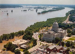
The Great Flood of 1993 was a flood that occurred in the Midwestern United States, along the Mississippi and Missouri rivers and their tributaries, from April to October 1993. The flood was among the most costly and devastating to ever occur in the United States, with $15 billion in damages. The hydrographic basin affected over around 745 miles (1,199 km) in length and 435 miles (700 km) in width, totaling about 320,000 square miles (830,000 km2). Within this zone, the flooded area totaled around 30,000 square miles (78,000 km2) and was the worst such U.S. disaster since the Great Mississippi Flood of 1927, as measured by duration, area inundated, persons displaced, crop and property damage, and number of record river levels. In some categories, the 1993 flood even surpassed the 1927 flood, at the time the largest flood ever recorded on the Mississippi.
The St. Francis River is a tributary of the Mississippi River, about 426 miles (686 km) long, in southeastern Missouri and northeastern Arkansas in the United States. The river drains a mostly rural area and forms part of the Missouri-Arkansas state line along the western side of the Missouri Bootheel.

Estevan is a provincial electoral district for the Legislative Assembly of Saskatchewan, Canada.
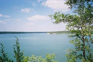
Lake Georgetown is a reservoir on the north fork of the San Gabriel River in central Texas in the United States. Lake Georgetown is a U.S. Army Corps of Engineers reservoir formed on the San Gabriel by the North San Gabriel Dam, which is located about three miles west of Georgetown, Texas. The dam, lake, and all adjacent property are managed by the Fort Worth District of the U.S. Army Corps of Engineers. The dam was officially completed on October 5, 1979, and serves to provide flood control for the community of Georgetown. Lake Georgetown is also a source of drinking water for Georgetown and the nearby city of Round Rock. The lake is also a popular recreational destination.
Lomond No. 37 is a rural municipality in south-eastern Saskatchewan, Canada south of Weyburn.
The Columbus and Western Railway (C&W) is a historic railroad that operated in Georgia, United States.

Wilson Township is one of eight townships in Audrain County, Missouri, United States. As of the 2010 census, its population was 1,633.

The Good News Voice is a network of Christian radio stations in Missouri. The network is owned by Missouri River Christian Broadcasting, Inc.
Goodwater Creek is a stream in the U.S. state of Missouri.

Goodwater is a populated place situated in Navajo County, Arizona. It has an estimated elevation of 5,262 feet (1,604 m) above sea level.
The 22nd San Diego Film Critics Society Awards were announced on December 11, 2017.


