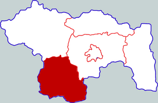
The canton of Chorges is an administrative division in southeastern France. At the French canton reorganisation which came into effect in March 2015, the canton was expanded from 8 to 17 communes:

Mrgastan is a village in the Armavir Province of Armenia. The town's church, dedicated to Saint Hovhannes, was built in 1912.

Jesionowo is a village in the administrative district of Gmina Tuchola, within Tuchola County, Kuyavian-Pomeranian Voivodeship, in north-central Poland. It lies approximately 2 kilometres (1 mi) north of Tuchola and 57 km (35 mi) north of Bydgoszcz.

Ağgədik is a village in the Khojali Rayon of Azerbaijan. Mikael Aramyants was from this town.
Wieżyce is a settlement in the administrative district of Gmina Szczucin, within Dąbrowa County, Lesser Poland Voivodeship, in southern Poland. It lies approximately 3 kilometres (2 mi) south of Szczucin, 14 km (9 mi) north-east of Dąbrowa Tarnowska, and 84 km (52 mi) east of the regional capital Kraków.
Józefinowo is a settlement in the administrative district of Gmina Łobżenica, within Piła County, Greater Poland Voivodeship, in west-central Poland.
Szrapki is a village in the administrative district of Gmina Dominowo, within Środa Wielkopolska County, Greater Poland Voivodeship, in west-central Poland. It lies approximately 1 kilometre (1 mi) south-east of Dominowo, 7 km (4 mi) north-east of Środa Wielkopolska, and 33 km (21 mi) south-east of the regional capital Poznań.
Okopa is a settlement in the administrative district of Gmina Bartoszyce, within Bartoszyce County, Warmian-Masurian Voivodeship, in northern Poland, close to the border with the Kaliningrad Oblast of Russia.

http://forthjunction.ca/blindman-valley-railway.htmFile:Canada+Alberta+location+map+2.svgFile:Red+pog.svgHoadley+Location+of+Hoadley+Alberta
Xiangcheng County is a county in the central part of Henan province, China. It is located in the southwest of the prefecture-level city of Xuchang, and is its southernmost county-level division.

Xiangning County is a county in the southwest of Shanxi province, China, bordering Shaanxi province across the Yellow River to the west. It is under the administration of the prefecture-level city of Linfen.
El Amra District is a district of Aïn Defla Province, Algeria.
Mahala is a village in the Republika Srpska, Bosnia and Herzegovina. According to the 1991 census, the village is located in the municipality of Rogatica.

Šavrane is a village in the municipality of Kruševac, Serbia. According to the 2002 census, the village has a population of 706 people.

Shuanglong station is the terminal station of Line 3 of the Shenzhen Metro. The station is elevated, beside Shenhui Road. It opened on 28 December 2010.

Kafar Souseh is a municipality and neighborhood of Damascus, Syria, located in the southwestern part of the capital. It is home to the Syrian Council of Ministers and the Syrian Ministry of Foreign Affairs.

Independence Square is a large square at the centre of Gyumri city, Armenia. It is the second square of the city after the central Vartanants Square. The square is intersected by the streets of Khrimian Hayrik, Garegin Nzhdeh, Alex Manoogian, Sayat Nova Avenue and Tigranes the Great Avenue. It has a shape of square and was completed during the 1940s, after World War II.

Pathargama is a community development block that forms an administrative division of Godda district, Jharkhand state, India. It is located 19 km from Godda, the district headquarters.

Maltepe Mosque or is a mosque in Ankara, Turkey. Along with Kocatepe Mosque, it is one of the best known mosques in Ankara.

Badamsha is a town in Aktobe Region, west Kazakhstan. It lies at an altitude of 419 m (1,375 ft). It has a population of 5,668.


