Coordinates: 45°10′26″N19°36′46″E / 45.1739°N 19.6128°E
A geographic coordinate system is a coordinate system that enables every location on Earth to be specified by a set of numbers, letters or symbols. The coordinates are often chosen such that one of the numbers represents a vertical position and two or three of the numbers represent a horizontal position; alternatively, a geographic position may be expressed in a combined three-dimensional Cartesian vector. A common choice of coordinates is latitude, longitude and elevation. To specify a location on a plane requires a map projection.
Grabovo (Cyrillic: Грабово) is a village in Serbia. It is situated in the Beočin municipality, in the Vojvodina province. Although, the village is geographically located in Syrmia, it is part of the South Bačka District. The village has a Serb ethnic majority. The population of the village, numbering 138 people according to a 2002 census, is steadily declining and the village is in danger of disappearing.
Serbia, officially the Republic of Serbia, is a country situated at the crossroads of Central and Southeast Europe in the southern Pannonian Plain and the central Balkans. The sovereign state borders Hungary to the north, Romania to the northeast, Bulgaria to the southeast, North Macedonia to the south, Croatia and Bosnia and Herzegovina to the west, and Montenegro to the southwest. The country claims a border with Albania through the disputed territory of Kosovo. Serbia's population is about seven million. Its capital, Belgrade, ranks among the oldest and largest citiеs in southeastern Europe.
Beočin is a town and municipality located in the South Bačka District of the autonomous province of Vojvodina, Serbia. The population of the town is 7,839, whilst Beočin's municipality population is 15,726. There is also a Beočin Monastery from the 16th century in the municipality.
Vojvodina, officially the Autonomous Province of Vojvodina, is an autonomous province of Serbia, located in the northern part of the country, in the Pannonian Plain.
The village is located on the northern part of Fruška Gora mountain. It has only one asphalt road: to Sviloš in the west, across the hill, approximately 2 km (1.2 mi); and two dirt roads to Banoštor in the north, next to the Tekeniš stream. Grabovo is approximately 220–280 m (720–920 ft) above sea level.
Fruška Gora is a mountain in north Srem. Most of it is in Syrmia, Serbia, but a small part on its western side overlaps into Croatia. Sometimes it is also referred to as jewel of Serbia due to its beautiful landscape protection area, nature and its picturesque countryside.
Asphalt, also known as bitumen, is a sticky, black, and highly viscous liquid or semi-solid form of petroleum. It may be found in natural deposits or may be a refined product, and is classed as a pitch. Before the 20th century, the term asphaltum was also used. The word is derived from the Ancient Greek ἄσφαλτος ásphaltos.
Sviloš is a village in Serbia. It is situated in the Beočin municipality, in the Vojvodina province. Although, the village is geographically located in Syrmia, it is part of the South Bačka District. The village has a Serb ethnic majority and its population numbering 362 people.
Grabovo is one of the most isolated villages in Beočin municipality, and also in the region. Bus No.84 connects the villages of Grabovo and Sviloš to Lug, Beočin and Novi Sad; it operates only on work days: three times a day to Grabovo (from Novi Sad via Beočin), and once a day from Grabovo.
Lug is a village in western part of the Serbian province of Vojvodina, in the municipality of Beočin, South Bačka District. It lies on the northwest slopes of Fruška gora mountain, in the region of Syrmia. The village has a population numbering 801 people, most of them being ethnic Slovaks.
Novi Sad is the second largest city in Serbia, the capital of the autonomous province of Vojvodina and the administrative centre of the South Bačka District. It is located in the southern portion of the Pannonian Plain on the border of the Bačka and Srem geographical regions. Lying on the banks of the Danube river, the city faces the northern slopes of Fruška Gora.
During the Axis occupation in World War II, 151 civilians were killed in Grabovo by fascists.
Village has one Serbian Orthodox Church, which is in ruins. It also has a small ambulance, a small tavern, and a grocery store.
The Serbian Orthodox Church is one of the autocephalous Eastern Orthodox Christian Churches. It is the second-oldest Slavic Orthodox Church in the world.
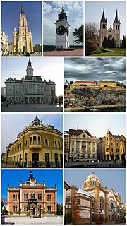
The South Bačka District is one of seven administrative districts of the autonomous province of Vojvodina, Serbia. Geographically it lies in the southern part of Bačka and northern part of Syrmia. According to the 2011 census results, it has a population of 615,371 inhabitants. The administrative center of the district is the city of Novi Sad, which is also the capital and the largest city of the Autonomous Province of Vojvodina.
Manđelos is a village located in the Sremska Mitrovica municipality, in the Syrmia District of Vojvodina, Serbia. The village has a Serb ethnic majority and its population numbering 1,533 people.
Batrovci is a village located in Syrmia, Vojvodina, Serbia. It is situated in the Šid municipality, in the Srem District. The village has a Serb ethnic majority and its population numbering 320 people.
Bačinci is a village located in Syrmia, Vojvodina, Serbia. It is situated in the Šid municipality, in the Syrmia District. The village has a Serb ethnic majority and its population numbering 1,374 people.
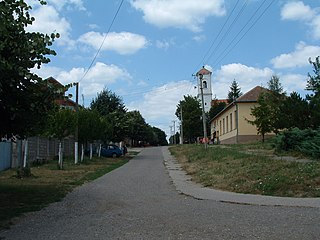
Ljuba is a village located in Syrmia, Vojvodina, Serbia. It is situated in the Šid municipality, in the Syrmia District. The village has a Slovak ethnic majority and its population was 558 people at the 2002 census.
Nadalj is a village located in the Srbobran municipality, in the South Bačka District of Serbia. It is situated in the Autonomous Province of Vojvodina. The village has a Serb ethnic majority and its population numbering 2,202 people.
Novi Slankamen is a village in Serbia. It is located in the municipality of Inđija, Syrmia District, Autonomous Province of Vojvodina. Novi Slankamen is situated about 15 kilometers east of Inđija, on the bank of Danube (Dunav) and has a total population of 3,421.
Gospođinci is a village in the municipality of Žabalj, in the South Bačka District of Serbia. It is situated in the Autonomous Province of Vojvodina. The village has a Serb ethnic majority and its population is 3,896.
Čelarevo is a village located in the Bačka Palanka municipality, in the South Bačka District of Serbia. It is situated in the Autonomous Province of Vojvodina. The village has a Serb ethnic majority and its population numbers 5,423 people.
Bešenovo is a village in Serbia. It is located in the Sremska Mitrovica municipality, in the Syrmia District, Vojvodina province. The village has a Serb ethnic majority and the population numbers 965 people. Near the village is Bešenovo monastery, one of 16 Serb Orthodox monasteries on the Fruška Gora mountain.
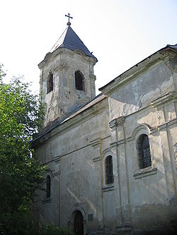
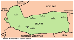
Banoštor is a village in Serbia. It is situated in the Beočin municipality, in the Vojvodina province. Although the village is geographically located in Syrmia, it is part of the South Bačka District. The village has a Serb ethnic majority and its population numbering 780 people.
Čerević is a village in Serbia. It is situated in the Beočin municipality, in the Vojvodina province. Although, the village is geographically located in Syrmia, it is part of the South Bačka District. The village has a Serb ethnic majority and its population numbers 2,826 people.
Rakovac is a village in Serbia. It is situated in the Beočin municipality which is in the Vojvodina province. Although, the village is geographically located in Syrmia, it is part of the South Bačka District. The village has a Serb ethnic majority and its population numbering 1,989 people as of the 2002 census. Rakovac is divided into two parts: Stari Rakovac and Novi Rakovac.
Susek is a village in Serbia. It is situated in the Beočin municipality, in the Vojvodina province. Although, the village is geographically located in Syrmia, it is part of the South Bačka District. The village has a Serb ethnic majority and its population numbering 1,132 people.
Dobrodol is a village in Serbia. It is located in the Irig municipality, in the Srem District, Vojvodina province. The village has a Hungarian ethnic majority and its population numbering 127 people.
Šatrinci is a village in Serbia. It is located in the Irig municipality, in the Srem District, Vojvodina province. The village has a Hungarian ethnic majority and its population numbering 399 people.
Gibarac is a village in Serbia. It is situated in the Šid municipality, in the Srem District, Vojvodina province. The village has a Serb ethnic majority and its population numbering 1,158 people.
Wikimedia Commons has media related to Grabovo . |
This article about a location in the Autonomous Province of Vojvodina is a stub. You can help Wikipedia by expanding it. |