
The Zambezi is the fourth-longest river in Africa, the longest east-flowing river in Africa and the largest flowing into the Indian Ocean from Africa. The area of its basin is 1,390,000 square kilometres (540,000 sq mi), slightly less than half of the Nile's. The 2,574-kilometre-long river (1,599 mi) rises in Zambia and flows through eastern Angola, along the north-eastern border of Namibia and the northern border of Botswana, then along the border between Zambia and Zimbabwe to Mozambique, where it crosses the country to empty into the Indian Ocean.

The Orange River is the longest river in South Africa and the Orange River Basin extends extensively into Namibia and Botswana to the north. It rises in the Drakensberg mountains in Lesotho, flowing westwards through South Africa to the Atlantic Ocean. The river forms part of the international borders between South Africa and Namibia and between South Africa and Lesotho, as well as several provincial borders within South Africa. Except for Upington, it does not pass through any major cities. The Orange River plays an important role in the South African economy by providing water for irrigation and hydroelectric power. The river was named the Orange River in honour of the Dutch ruling family, the House of Orange, by the Dutch explorer Robert Jacob Gordon. Other names include Gariep River, Groote River or Senqu River.

The Housatonic River is a river, approximately 149 miles (240 km) long, in western Massachusetts and western Connecticut in the United States. It flows south to southeast, and drains about 1,950 square miles (5,100 km2) of southwestern Connecticut into Long Island Sound. Its watershed is just to the west of the watershed of the lower Connecticut River. Birds and fish who live in and around the river contain significant levels of PCBs and present health risks.

The Namoi River, a major perennial river that is part of the Barwon catchment of the Murray–Darling basin, is located in the Northern Tablelands and North West Slopes districts of New South Wales, Australia.

The Wolf River is a 225 mi (362 km) long tributary of the Fox River in northeastern Wisconsin in the Great Lakes region of the United States. The river is one of the two National Scenic Rivers in Wisconsin, along with the St. Croix River. The scenic portion is 24 miles (39 km) long. The river and its parent the Fox River and associated lakes are renown for their sturgeon which spawn every spring upstream on the lower river until blocked by the Shawano Dam. The river flows through mostly undeveloped forestland southerly from central Forest County in the north to Lake Poygan in the south. The lake is part of the Winnebago Pool of lakes fed by both the Fox and Wolf Rivers. The Fox-Wolf basin is usually considered to be a single unified basin and the rivers themselves may be referred to as the Fox-Wolf River system.
The Olifants River is a river in the northwestern area of the Western Cape Province of South Africa. The upper and main catchment area of the Olifants river is around Ceres and the Cederberg mountains. The Clanwilliam and Bulshoek dams are located on the river and provide water for the towns and farms along the watercourse. The river is approximately 285 km long with a catchment area of 46,220 km2 and flows into the Atlantic Ocean at Papendorp, 250 km north of Cape Town.

The Great Kei River is a river in the Eastern Cape province of South Africa. It is formed by the confluence of the Black Kei River and White Kei River, northeast of Cathcart. It flows for 320 km (199 mi) and ends in the Great Kei Estuary at the Indian Ocean with the small town Kei Mouth on the west bank. Historically the Great Kei River formed the southwestern border of the Transkei region.

The Great Fish River is a river running 644 kilometres (400 mi) through the South African province of the Eastern Cape. The coastal area between Port Elizabeth and the Fish River mouth is known as the Sunshine Coast. The Great Fish River was originally named Rio do Infante, after João Infante, the captain of one of the caravels of Bartolomeu Dias. Infante visited the river in the late 1480s.
Tigerfish can refer to fish from various families, and derives from official and colloquial associations of these with the tiger. However, the primary species designated by the name "tigerfish" are African and belong to the family Alestidae.

Gariep Dam located in South Africa, near the town of Norvalspont, bordering the Free State and Eastern Cape provinces. Its primary purpose is for irrigation, domestic and industrial use as well as for power generation.
The Sundays River or Nukakamma is a river in the Eastern Cape Province of South Africa. It is said to be the fastest flowing river in the country. The Khoisan people originally named this river Nukakamma because the river's banks are always green and grassy despite the arid terrain that it runs through.
Nandoni Dam, previously known as the Mutoti Dam, is an earth-fill/concrete type dam in Limpopo province, South Africa. It is located on the Luvuvhu River near the villages of ha-Mutoti and ha-Budeli and ha-Mphego just a few kilometres from Thohoyandou in the district of Vhembe. The dam serves primarily for water supply and its hazard potential has been ranked high (3).
Fish to Tsitsikama WMA, or Fish to Tsitsikama Water Management Area , in South Africa Includes the following major rivers: the Fish River, Kowie River, Boesmans River, Sundays River, Gamtoos River, Kromme River, Tsitsikamma River and Groot River, and covers the following Dams:
Darlington Dam, also referred to as Lake Mentz. is a gravity type dam situated in the Sundays River, near Kirkwood, in Eastern Cape, South Africa. It was established in 1922 and was renovated in 1952. The dam has a capacity of 187,000,000 cubic metres (6.6×10⁹ cu ft), with a 35.3 metres (116 ft)-high wall. Its primary purpose is for irrigation, industrial and domestic use.
Pongolapoort Dam, commonly referred to as Lake Jozini, is an arch type dam in northern KwaZulu-Natal, South Africa located on the Phongolo River. The dam is situated 280 km north-east of the port city of Durban. The dam was constructed in 1973 at the eastern end of the narrow gorge separating the Lebombo and Ubombo ranges and was the largest dam in South Africa at the time of its construction. The dam mainly serves for irrigation purposes and its hazard potential has been ranked high (3). The Phongolo River is the dams largest feeder as well as the dams only perennial feeder.
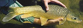
The smallmouth yellowfish is a species of ray-finned fish in the genus Labeobarbus. It has become an invasive species in rivers of the Eastern Cape, South Africa, such as the Mbhashe River.

The Kouga River originates near Uniondale, Eastern Cape, South Africa, and flows eastward, where it joins the Groot River to form the Gamtoos just past the Kouga Dam. Its main tributary is the Baviaanskloof River, which joins its left bank before the dam.

Krom River or Kromme River is a river in the Eastern Cape Province in South Africa. The river flows into the Indian Ocean through an estuary on the north side of St Francis Bay, west of Port Elizabeth. The Krom river flows in an ESE direction and is approximately 109 km long with a catchment area of 1,085 km².

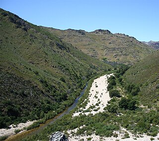
The Kat River is a tributary of the Great Fish River, that drains the southern slopes of the Winterberg in the Eastern Cape Province, South Africa.


