
New Hampshire is a state in the New England region of the Northeastern United States. It borders Massachusetts to the south, Vermont to the west, Maine and the Gulf of Maine to the east, and the Canadian province of Quebec to the north. Of the 50 U.S. states, New Hampshire is the fifth smallest by area and the tenth least populous, with a population of 1,377,529 residents as of the 2020 census. Concord is the state capital and Manchester is the most populous city. New Hampshire's motto, "Live Free or Die", reflects its role in the American Revolutionary War; its nickname, "The Granite State", refers to its extensive granite formations and quarries. It is well known nationwide for holding the first primary in the U.S. presidential election cycle, and for its resulting influence on American electoral politics.

Poland is a town in Androscoggin County, Maine, United States. The population was 5,906 at the 2020 census. Set among rolling hills and numerous lakes, the town is home to Range Ponds State Park, which includes hiking trails and a pristine freshwater beach. Poland is also a historic resort area. It is included in the Lewiston-Auburn, Maine metropolitan statistical area, which itself is part of the Greater Portland-Lewiston Combined Statistical Area.

Belgrade is a town in Kennebec County, Maine, United States. Its population was 3,250 at the 2020 census. However, its population approximately doubles during the summer months as part-year residents return to seasonal camps on the shores of Great Pond, Long Pond and Messalonskee Lake. Belgrade includes the villages of North Belgrade, Belgrade Depot and Belgrade Lakes. It is included in the Augusta, Maine micropolitan New England City and Town Area.

Wakefield is a town in Carroll County, New Hampshire, United States. The population was 5,201 at the 2020 census. The town includes the villages of Wakefield Corner, East Wakefield, North Wakefield, Sanbornville, Union, Woodman and Province Lake. Wakefield Corner, popular with tourists, is a picturesque hilltop village of antique buildings. The state of Maine forms the eastern border of Wakefield.
Crystal Lake or Crystal Lakes may refer to:
Pleasant Lake may refer to:

Great East Lake is an 1,825-acre (7.4 km2) water body located in Carroll County, New Hampshire, and York County, Maine, in the United States. The lake is shared by the towns of Wakefield, New Hampshire, and Acton, Maine, with 45% of its surface area in Acton and 55% in Wakefield. The lake is the farthest upstream of the five headwater lakes of the Salmon Falls River, a tributary of the Piscataqua River. Water from Great East Lake flows out its dam and through the 800-foot (240 m) Newichawannock Canal into Horn Pond, then into the Salmon Falls River below Horn Pond.

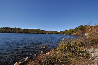
Pine River Pond is a 570-acre (2.3 km2) lake located in Carroll County in eastern New Hampshire, United States, in the town of Wakefield. Its outlet is the Pine River, which flows northwest to Ossipee Lake.
Beaver Brook is a 30.7-mile-long (49.4 km) river located in New Hampshire and Massachusetts in the United States. It is a tributary of the Merrimack River, part of the Gulf of Maine watershed.
Island Pond is a village in the town of Brighton, Vermont, United States.

The Powwow River is a 22.8-mile-long (36.7 km) river located in New Hampshire and Massachusetts in the United States. It is a tributary of the Merrimack River, part of the Gulf of Maine watershed.

The North Branch of the Millers River is a river in southwestern New Hampshire and northern Massachusetts in the United States. It is a tributary of the Millers River, which flows west to the Connecticut River, which in turn flows south to Long Island Sound, an arm of the Atlantic Ocean.
The South Branch of the Souhegan River is a 5.8-mile-long (9.3 km) river located in northern Massachusetts and southern New Hampshire in the United States. It is a tributary of the Souhegan River, which flows to the Merrimack River and ultimately to the Gulf of Maine.
A great pond in the United States is a pond or lake that is held in trust by the state for public use. Generally, any natural body of water that is larger than 10 acres (40,000 m2) in size is public water. In certain New England states, this legal definition exists at both common law and statutory law.

Frensham Common is a large Site of Special Scientific Interest (SSSI) heathland of 373 hectares which includes two lakes; it is owned and operated by the National Trust.

Salmon Brook is one of the six major tributaries of the Merrimack River in northeastern Massachusetts in the United States. Its watershed is 31 square miles (80 km2) and is one of the 14 subwatersheds of the Merrimack River. It passes through Dunstable, Massachusetts, and Nashua, New Hampshire.

Hopkins Pond is a small pond located at the south foot of Ragged Mountain, in the town of Andover, New Hampshire, United States. It lies at an elevation of 644 feet (196 m). The pond is part of Proctor Academy's 2,500-acre (10 km2) campus in Andover and is jointly managed by Proctor and the New Hampshire Fish and Game Department. The pond area is open to the public for non-motorized boat travel, fishing and hiking.
Horn Pond is a 227-acre (92 ha) water body located on the border of Acton, Maine, and Wakefield, New Hampshire, in the United States. The lake is both spring-fed and fed by the outflows of Great East Lake to the north and Wilson Lake to the east. Horn Pond's outlet is the Salmon Falls River which forms a natural border between Maine and New Hampshire and empties into the Piscataqua River east of Dover, New Hampshire, and ultimately the Gulf of Maine.

Potanipo Pond is a 136-acre (55 ha) water body located in Hillsborough County in southern New Hampshire, United States, in the town of Brookline. Potanipo Pond is the source of the Nissitissit River, which flows via the Nashua River into the Merrimack River, and then to the Gulf of Maine.

The Newichawannock Canal is a man-made canal which drains Great East Lake into Horn Pond at the border between Wakefield, New Hampshire, and Acton, Maine, in the northeastern United States. It is at the head of the Salmon Falls River, which the Abenaki called Newichawannock, meaning "river with many falls". Begun in 1850 by the Great Falls Company to increase the water available for its mills in Somersworth, New Hampshire, the 0.75-mile (1.21 km) canal is unusual as it was built for strictly industrial purposes in an area remote from the actual industrial site. The canal forms the boundary between the states of New Hampshire and Maine, and is spanned by a stone bridge built at the same time. The canal and bridge, along with related artifacts, were listed on the National Register of Historic Places in 2014.