
Becontree or is an area of approximately 4 square miles (10 km2) in the London Borough of Barking and Dagenham. It is located 11 miles (17.7 km) east-northeast of Charing Cross and was constructed in the interwar period as the largest public housing estate in the world. The Housing Act 1919 permitted the London County Council to build housing outside the County of London and Becontree was constructed between 1921 and 1935 to cottage estate principles in the parishes of Barking, Dagenham and Ilford, then in the administrative and ceremonial county of Essex. The official completion of the estate was celebrated in 1935, by which time the estate had a population of around 100,000 people in 26,000 homes.

The London Borough of Barking and Dagenham is a London borough in East London. It lies around 9 miles (14.4 km) east of Central London. It is an Outer London borough and the south is within the London Riverside section of the Thames Gateway; an area designated as a national priority for urban regeneration. At the 2011 census it had a population of 187,000, the majority of which are within the Becontree estate. The borough's three main towns are Barking, Chadwell Heath and Dagenham. The local authority is the Barking and Dagenham London Borough Council. Barking and Dagenham was one of six London boroughs to host the 2012 Summer Olympics.
Dagenham is a town in East London, England, within the London Borough of Barking and Dagenham. Dagenham is centred 11.5 miles (18.5 km) east of Charing Cross.

East Ham is a district of the London Borough of Newham, England, 8 miles (12.8 km) east of Charing Cross. East Ham is identified in the London Plan as a Major Centre. The population is 76,186.
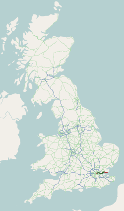
The A13 is a major road in England linking Central London with east London and south Essex. Its route is similar to that of the London, Tilbury and Southend line via Rainham, Grays, Tilbury & Stanford-Le-Hope, and runs the entire length of the northern Thames Gateway area, terminating on the Thames Estuary at Shoeburyness. It is a trunk road between London and the Tilbury junction, a primary route between there and Sadlers Hall Farm near South Benfleet, and a non-primary route between there and Shoeburyness.

Chadwell Heath is a town in East London, England. It is split between the London Borough of Barking and Dagenham and the London Borough of Redbridge, around 2 miles (3.2 km) west of Romford and 4 miles (6.4 km) east of Ilford, and 12 miles (19 km) north-east of Charing Cross.

Elm Park is a London Underground station serving Elm Park in the London Borough of Havering, east London. It is on the District line between Dagenham East and Hornchurch. It is 4 kilometres (2.5 mi) along the line from the eastern terminus at Upminster and 30 kilometres (19 mi) to Earl's Court in central London where the line divides into numerous branches.
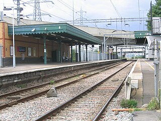
Dagenham Dock is a National Rail station in the Dagenham Dock neighbourhood of Dagenham in the London Borough of Barking and Dagenham, east London. The station is on the Tilbury loop of the London, Tilbury and Southend line, located 10 miles 45 chains (17.0 km) down the line from London Fenchurch Street between Barking to the west and Rainham to the east. The station was opened in 1908 by the London, Tilbury and Southend Railway. The station serves a primarily industrial area adjacent to the River Thames, including the Ford Dagenham site, that is now going through redevelopment as a commercial and residential district. Its three-letter station code is DDK and it is in London fare zone 5. The station and all trains serving it are currently operated by c2c. It is an interchange with the East London Transit bus service.

East London is the northeastern part of London, United Kingdom. Located east of the ancient City of London and north of the River Thames as it begins to widen, East London developed as London's docklands and the primary industrial centre. The expansion of railways in the 19th century encouraged the eastward expansion of the East End of London and a proliferation of new suburbs. The industrial lands of East London are today an area of regeneration, which are well advanced in places such as Canary Wharf and ongoing elsewhere.

Rush Green is a suburban area in Romford in East London, England. It straddles the boundary of the London Borough of Barking and Dagenham and the London Borough of Havering, and is located 13.5 miles (22 km) east-northeast of Charing Cross.

East London Transit (ELT) is a part-segregated bus rapid transit, operated as part of the London Buses network. The East London Transit opened in phases between 2010 and 2013. The scheme for this system was developed by Transport for London to meet the existing and anticipated demand for public transport in East London caused by the Thames Gateway redevelopment, and has been planned to allow for a possible future upgrade to tram operation.

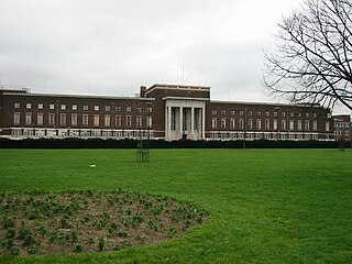
Valence House Museum is the only surviving of the five manor houses of Dagenham. The timber-framed museum building, partially surrounded by a moat, is situated in Valence Park off Becontree Avenue, in the London Borough of Barking and Dagenham, London, England. The building has been used as a manor house, a family home, a town hall, the headquarters of the library service and now houses a museum.
The London Borough of Barking and Dagenham, one of the outer London boroughs, has over 25 parks, gardens and open spaces within its boundaries. These provide the "green lungs" for leisure activities.
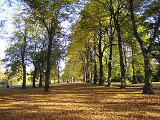
Barking Park is a public park covering 30 hectares to the northeast of Barking town centre in east London. It was opened as the Recreation Ground in 1898 by the Barking Town Urban District Council and is now the oldest public park in the London Borough of Barking and Dagenham. It lies north of Longbridge Road and south of the neighbourhood of Loxford, with the northern boundary of the park along Loxford Water also the borough boundary with Redbridge.
There are various formal and informal subdivisions of London Borough of Barking and Dagenham and of parts of that borough.
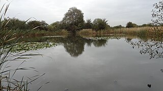
The Chase is a nature reserve in Dagenham in London. Most of it is in the London Borough of Barking and Dagenham, with a small part in Havering. It is owned by the boroughs, and managed by London Borough of Barking & Dagenham - Parks & Countryside Ranger Service. The boroughs have designated the sections in their respective boroughs as Local Nature Reserves. The Chase, together with the neighbouring Eastbrookend Country Park, is also designated a Site of Metropolitan Importance for Nature Conservation.

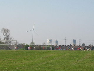
Parsloes Park is a 58 hectare public park in Dagenham in the London Borough of Barking and Dagenham. It is owned and managed by the borough council. A small area opposite the Wren Road entrance is managed for wildlife and designated as a Local Nature Reserve called Parsloes Park Squatts.

Cycleway 3 (C3) is a cycle path in London, United Kingdom. It is part of the Cycleway network coordinated by TfL. It runs from Barking in the east to Lancaster Gate in central London. It is a popular route with both commuter and leisure cyclists, passing a number of major destinations in London along its route. For almost the entire route, cyclists are separated from other traffic in segregated cycle lanes, and cycling infrastructure has been provided at major interchanges. The cycleway, originally called CS3, is renamed to Cycleway 3 (C3) in January 2023.

Castle Green is a proposed railway station in the London Borough of Barking and Dagenham. Plans for a station at the site, initially called Renwick Road, have been in development since at least 2002. The new station was first proposed to be between Barking and Dagenham Dock on the London, Tilbury and Southend line. In 2017 a station was safeguarded on the extension of the Gospel Oak to Barking line between Barking and Barking Riverside. The station would serve the communities of Castle Green, Thames View Estate and new housing developments in the area.
