
Pettis County is a county located in west central U.S. state of Missouri. As of the 2010 census, the population was 42,201. Its county seat is Sedalia. The county was organized January 24, 1833, and named after former U.S. Representative Spencer Darwin Pettis.

The Mid-Atlantic Ridge (MAR) is a mid-ocean ridge, a divergent tectonic plate or constructive plate boundary located along the floor of the Atlantic Ocean, and part of the longest mountain range in the world. In the North Atlantic, it separates the Eurasian and North American plates, and in the South Atlantic, it separates the African and South American plates. The ridge extends from a junction with the Gakkel Ridge northeast of Greenland southward to the Bouvet Triple Junction in the South Atlantic. Although the Mid-Atlantic Ridge is mostly an underwater feature, portions of it have enough elevation to extend above sea level. The section of the ridge that includes Iceland is known as the Reykjanes Ridge. The ridge has an average spreading rate of about 2.5 centimetres (0.98 in) per year.

The Blue Ridge Mountains are a physiographic province of the larger Appalachian Mountains range. The mountain range is located in the eastern United States, and extends 550 miles southwest from southern Pennsylvania through Maryland, West Virginia, Virginia, North Carolina, South Carolina, Tennessee, Georgia, and Alabama. This province consists of northern and southern physiographic regions, which divide near the Roanoke River gap. To the west of the Blue Ridge, between it and the bulk of the Appalachians, lies the Great Appalachian Valley, bordered on the west by the Ridge and Valley province of the Appalachian range.

Phinney Ridge is a neighborhood in north central Seattle, Washington, United States. It is named after the ridge which runs north and south, separating Ballard from Green Lake, from approximately N. 45th to N. 85th Street. The ridge, in turn, is named after Guy C. Phinney, lumber mill owner and real estate developer, whose estate was bought by the city and turned into Woodland Park in 1899. Phinney's estate had included a private menagerie, and the western half of the park became what is now the Woodland Park Zoo.

The Bay Area Ridge Trail is a planned 550-mile (890 km) multi-use trail along the hill and mountain ridgelines ringing the San Francisco Bay Area, in Northern California. When complete, the trail will connect over 75 parks and open spaces. The trail is being designed to provide access for hikers, runners, mountain bicyclists, and equestrians. It will be accessible through trailheads near major population centers, while the trail will extend into more remote areas. The first trail section was dedicated on May 13, 1989.

The Eastern Ridges and Lowlands is a geographical region in the eastern part of the U.S. state of Wisconsin, between Green Bay in the north, and the border with Illinois in the south. Lake Michigan lies to the east of the region.

Breakneck Ridge is a mountain along the Hudson River between Beacon and Cold Spring, New York, straddling the boundary between Dutchess and Putnam counties. Its distinctive rocky cliffs are visible for a long distance when approached from the south, and together with Storm King Mountain on the opposite bank of the river forms Wey-Gat, or Wind Gate, the picturesque northern gateway to the Hudson Highlands.

The Garibaldi Ranges are the next-to-southwesternmost subdivision of the Pacific Ranges of the Coast Mountains; only the North Shore Mountains are farther southwest. They lie between the valley formed by the pass between the Cheakamus River and Green River on the west and the valley of the Lillooet River on the east, and extend south into Maple Ridge, an eastern suburb of Vancouver, and the northern District of Mission. To their south are the North Shore Mountains overlooking Vancouver while to their southeast are the Douglas Ranges.
Pastrana 199 Racing is a NASCAR Nationwide Series team that competed in the NASCAR Cup Series and Busch Series from 1990 to 1999, and revived as a Nationwide Series team in 2010. The original Diamond Ridge team was owned and operated by Gary Bechtel. Despite modest success in the Busch Series, the team was never able to maintain a competitive level in the Winston Cup Series. The team was revived as a partnership with Michael Waltrip Racing in 2010 as Diamond-Waltrip Racing, running full-time in the Nationwide Series with Trevor Bayne. For 2011 the team partnered with action star Travis Pastrana and MWR development driver Ryan Truex, though the team shuttered temporarily due to Pastrana's injuries at the 2011 Summer X Games and a lacking sponsor. The team changed its name to Pastrana 199 Racing, a reference to Pastrana's standard number. The team was to field the No. 99 for Pastrana, but the deal was cancelled when Michael Waltrip Racing aligned with RAB Racing to field the No. 99.

The Tom Ridge Environmental Center is a center on the grounds of Presque Isle State Park in Erie, Pennsylvania. Named after former Pennsylvania Governor and former U.S. Department of Homeland Security Director Tom Ridge, the center opened on 26 May 2006. The center has 65,000 square feet (6,039 m2) of space including interpretive exhibits highlighting local and regional flora and fauna, as well as information on the human history and culture of the area. The center also has a large-format movie theater, a gift shop, a cafe, a visitors center, and an observation tower of 75 feet (23 m) that overlooks Lake Erie. The facility also has five conference rooms and eight laboratories for environmental education and research of supporting organizations, plus the administrative offices of several environmental and conservation groups and agencies.
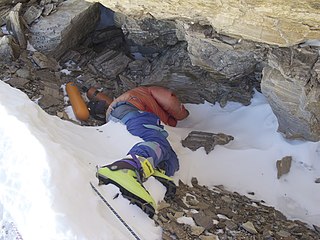
Green Boots is the name given to the unidentified corpse of a climber that became a landmark on the main Northeast ridge route of Mount Everest. Though his identity has not been officially confirmed, he is believed to be Tsewang Paljor, an Indian climber who died on Mount Everest in 1996. The term Green Boots originated from the green Koflach mountaineering boots that are on the feet of the corpse. All expeditions from the north side encountered the body curled in the limestone alcove cave at 8,500 m (27,900 ft). In 2006, a different climber, David Sharp, died during a solo climb in what is known as "Green Boots' Cave".
Misery Mountain, 2,671 feet (814 m), with at least ten well-defined summits, is a prominent 6 mi (9.7 km) long rideline in the Taconic Mountains of western Massachusetts and adjacent New York. The west side of the mountain is located in New York; the east side and high point lie within Massachusetts. The summit ridge is part meadow and part wooded with red spruce, balsam fir, and northern hardwood tree species. It is notable for its views of the Hudson River Valley to the west. The 35 mi (56 km) Taconic Crest Trail traverses the crest of the ridgeline, but does not cross the summit.

Brodie Mountain, 2,621 feet (799 m), is a prominent 5.5-mile (8.9 km) long ridgeline in the Taconic Mountains of western Massachusetts, known for the former Brodie Mountain ski area, which closed in 2002. The ridge has eight well defined summits, three of which have names: Sheep's Heaven Mountain, 2,530 feet (770 m), the ridge's southern prominatory; Beoadic Mountain, the ridge high point, just north of Sheep's Heaven; and East Mountain, 2,613 feet (796 m) located at the top of the former ski area at the center of the ridge. A northern summit, 2,170 feet (660 m), is shown as "Brodie Mountain" on maps that predate the Brodie Mountain ski area.
White Rock, 2,550 feet (780 m), is the high point on a 7 mi (11 km) ridgeline in the Taconic Mountains. The ridge is located in the tri-state corner of New York, Massachusetts, and Vermont in the towns of Petersburgh, Williamstown, and Pownal. The ridge has several distinct knobs; those with names are, from south to north: White Rocks, 2,365 feet (721 m); Smith Hill, 2,330 feet (710 m); White Rock, the high point 2,550 feet (780 m); and Bald Mountain 2,485 feet (757 m). The Snow Hole, located along the ridgeline between Bald Mountain and the White Rock, is a crevasse in which snow can be found well into the summer.

Green Ridge State Forest is a state forest in Western Maryland. Approximately 46,000 acres (186 km2) in size, it is situated along Green Ridge and Town Hill in eastern Allegany County.

Dry Ridge Mountain (10,326 feet is located in the Teton Range in the U.S. state of Wyoming. The peak is on the border of Grand Teton National Park and the Jedediah Smith Wilderness of Caribou-Targhee National Forest. Dry Ridge Mountain is at the head of Moran Canyon and 1 mile NNE of Green Lakes Mountain.

University Ridge Golf Course is a public golf course in the central United States, located in Verona and Madison, Wisconsin. It is the home course to both the men's and women's golf teams for the University of Wisconsin. Also, since 1994, it has been home to both the boys' and girls' WIAA state golf championships for all divisions. The Thomas Zimmer Championship Cross Country Course is also located on the property.

