
Cranleigh is a village and civil parish, about 8 miles (13 km) southeast of Guildford in Surrey, England. It lies on a minor road east of the A281, which links Guildford with Horsham. It is in the north-west corner of the Weald, a large remnant forest, the main local remnant being Winterfold Forest directly north-west on the northern Greensand Ridge.

The South West Coast Path is England's longest waymarked long-distance footpath and a National Trail. It stretches for 630 miles (1,014 km), running from Minehead in Somerset, along the coasts of Devon and Cornwall, to Poole Harbour in Dorset. Because it rises and falls with every river mouth, it is also one of the more challenging trails. The total height climbed has been calculated to be 114,931 ft (35,031 m), almost four times the height of Mount Everest. It has been voted 'Britain's Best Walking route' twice in a row by readers of The Ramblers' Walk magazine, and regularly features in lists of the world's best walks.
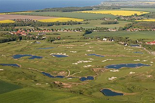
A golf course is the grounds on which the sport of golf is played. It consists of a series of holes, each consisting of a tee box, a fairway, the rough and other hazards, and a green with a cylindrical hole in the ground, known as a "cup". The cup holds a flagstick, known as a "pin". A standard round of golf consists of 18 holes, and as such most courses contain 18 distinct holes; however, there are many 9-hole courses and some that have holes with shared fairways or greens. There are also courses with a non-standard number of holes, such as 12 or 14.
The A25 road is an east–west main road in the South-East of England. Its carries traffic east from Guildford, Surrey, eastward through Surrey and into mid-west Kent, to the town of Sevenoaks, and then on to Wrotham Heath where it connects with the A20.

Hambledon is a rural scattered village in the Waverley borough of Surrey, situated south of Guildford. It is dominated by a buffer zone of fields and woodland, mostly south of the Greensand Ridge escarpment between Witley and Chiddingfold, having no dual carriageways or railways; however, it is bordered to the west by the Portsmouth Direct Line, and many of its small population are London commuters or retirees. Its main amenities are a church, a village pub, and the village shop and post office.

Greensand or green sand is a sand or sandstone which has a greenish color. This term is specifically applied to shallow marine sediment that contains noticeable quantities of rounded greenish grains. These grains are called glauconies and consist of a mixture of mixed-layer clay minerals, such as smectite and glauconite. Greensand is also loosely applied to any glauconitic sediment.

Glauconite is an iron potassium phyllosilicate mineral of characteristic green color which is very friable and has very low weathering resistance.

Sand casting, also known as sand molded casting, is a metal casting process characterized by using sand as the mold material. The term "sand casting" can also refer to an object produced via the sand casting process. Sand castings are produced in specialized factories called foundries. Over 60% of all metal castings are produced via sand casting process.

The Surrey Hills is a 422 km2 (163 sq mi) Area of Outstanding Natural Beauty (AONB), which principally covers parts of the North Downs and Greensand Ridge in Surrey, England. The AONB was designated in 1958 and adjoins the Kent Downs AONB to the east and the South Downs National Park in the south west.

Moraine State Park is a Pennsylvania state park on 16,725 acres (6,768 ha) in Brady, Clay, Franklin, Muddy Creek, and Worth townships in Butler County, Pennsylvania.

The Greensand Way is a long-distance path of 108 miles (174 km) in southeast England, from Haslemere in Surrey to Hamstreet in Kent. It follows the Greensand Ridge along the Surrey Hills and Chart Hills. The route is mostly rural, passing through woods, and alongside fruit orchards and hop farms in Kent and links with the Stour Valley Walk near Pluckley in Kent. The trail was opened on 15 June 1980 and is jointly managed by Surrey and Kent Councils who fully updated it in 2012.
The Vanguard Way is a long-distance walk of 66.2 mi (106.5 km) from East Croydon station in outer London, travelling from the north, to Newhaven, on the south coast of England. It passes through the counties of Surrey, Kent and East Sussex, between Croydon and Newhaven, East Sussex. It connects the London suburbs to the south coast, via the North Downs, Ashdown Forest, South Downs National Park and the Cuckmere valley.

The Greensand Ridge, also known as the Wealden Greensand is an extensive, prominent, often wooded, mixed greensand/sandstone escarpment in south-east England. Forming part of the Weald, a former dense forest in Sussex, Surrey and Kent, it runs to and from the East Sussex coast, wrapping around the High Weald and Low Weald. It reaches its highest elevation, 294 metres (965 ft), at Leith Hill in Surrey—the second highest point in south-east England, while another hill in its range, Blackdown, is the highest point in Sussex at 280 metres (919 ft). The eastern end of the ridge forms the northern boundary of Romney Marsh.
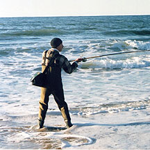
Surf fishing is land-based game fishing while standing on the shoreline or wading into the surf zone. A general term, surf fishing may or may not include casting a lure or bait, and refers to all types of shore fishing – from sandy and rocky beaches, rock jetties, or even fishing piers. The terms surfcasting or beachcasting refer more specifically to surf fishing from the beach by casting into the surf at or near the shoreline. With few exceptions, surf fishing is done in saltwater. The most common misconception about surf fishing is the idea that one must cast as far out as possible in order to reach the fish. At beaches on the west coast of the United States, and in fact, at most beaches around the world, you only really need to get your bait into knee-deep water. This is referred to as surf fishing the "skinny".

The Sussex Border Path is a long-distance footpath around the borders of Sussex, a historic county and former medieval kingdom in southern England. The main path is 150 miles (240 km) long and stays close to Sussex's borders with Hampshire, Surrey and Kent, connecting Thorney Island to Rye. There is also an additional 33-mile (53 km) spur known as the Mid Sussex Link, which links East Grinstead with Fishersgate and Mile Oak on the western boundary of the city of Brighton and Hove.
Bedfordshire Greensand Ridge is an escarpment which runs through Buckinghamshire, Bedfordshire, and Cambridgeshire in the south and east of England. A pathway runs along the ridge from Leighton Buzzard to Gamlingay. In 2009, the Greensand Ridge Local Action Group was formed to help enhance and develop the Greensand Ridge area. The Group bid for funding from the Rural Development Programme for England and were successful. Since 2009, the Greensand Ridge Rural Development Programme, delivered by Bedfordshire Rural Communities Charity, has awarded grants to businesses and organisations which meet their objectives.

The Lower Greensand Group is a geological unit present across large areas of Southern England. It was deposited during the Aptian and Albian stages of the Early Cretaceous. It predominantly consists of sandstone and unconsolidated sand that were deposited in shallow marine conditions.
The Greensand Ridge Walk is a long-distance walk of 40 miles (64 km) that traverses the county of Bedfordshire in England, with brief sections in the neighbouring counties of Cambridgeshire and Buckinghamshire. Its southern endpoint is at Leighton Buzzard and the route runs north-east to finish at Gamlingay. As can be inferred from the name, the walk follows the Bedfordshire Greensand Ridge.
The geology of Kent in southeast England largely consists of a succession of northward dipping late Mesozoic and Cenozoic sedimentary rocks overlain by a suite of unconsolidated deposits of more recent origin.
(Greensand Cycleway) Signs for this route appeared in the first half of 2014. It covers roughly 40 miles (64 km), using minor roads and runs roughly in parallel with its sister walk, the Greensand Ridge Walk. The route traverses Bedfordshire, making brief forays into the neighbouring counties of Cambridgeshire and Buckinghamshire. Its southern endpoint is at Leighton Buzzard and the route runs north-east to Sandy. The waymarker for this route is simply Greensand Cycleway and the depiction of a bicycle on a brown background. There are some smaller, circular waymarkers employed to ensure continuity of the route for cyclists.