Dyke or dike may refer to:
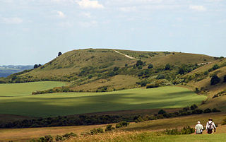
Ivinghoe Beacon is a prominent hill and landmark in Buckinghamshire, England, 233 m (757 ft) above sea level in the Chiltern Hills, close to Ivinghoe and Aldbury. Dunstable, Berkhamsted and Tring are nearby.

Chivery is a hamlet located in the Chiltern Hills in the present day parish of Aston Clinton, in Aylesbury Vale District in the county of Buckinghamshire, England.

Harrow Weald is a suburban district in Greater London, England. Located about 2 miles north of Harrow, Harrow Weald is formed from a leafy 1930s suburban development along with ancient woodland of Harrow Weald Common. It forms part of the London Borough of Harrow.

The Berkshire Downs are a range of chalk downland hills in southern England, part of the North Wessex Downs Area of Outstanding Natural Beauty. The Berkshire Downs are wholly within the traditional county of Berkshire, although split between the current ceremonial counties of Berkshire and Oxfordshire. The western parts of the downs are also known as the Lambourn Downs.
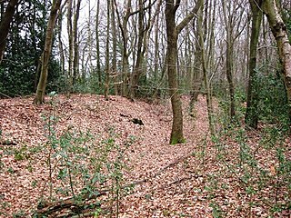
Grim's Ditch is a series of linear earthwork in the Chilterns. A complete outline cannot be identified but separate sections exist over a 30-kilometre (19 mi) span between Bradenham, Buckinghamshire, Berkhamsted, Hertfordshire and as far as Pitstone and Ivinghoe Buckinghamshire. Pottery shards have been unearthed in excavations during the 1970s and 1980s suggesting that its origin may have been during the Iron Age and was believed to have been during a period when the landscape was clearer of scrub and the dense woodland than today as the straighter sections would have required clear lines of sight. The first mention of Grim's Ditch was a grant of 1170–90 in the Missenden Cartulary referring to it as Grimesdic. The Anglo Saxons commonly named features of unexplained or mysterious origin Grim. The word derives from the Norse word grimr meaning devil and a nickname for Odin or Wodin the God of War and Magic. Another mention is to be found in a 10th-century Anglo Saxon boundary charter for the Mongewell area.

Buckland Common is a hamlet in Buckinghamshire, England. It is located in the Chiltern Hills, 4 miles (6.4 km) east of Wendover and the same distance south of Tring in Hertfordshire with which it shares a boundary. The northern end of the settlement is delineated by a short section of Grim's Ditch. It is in the civil parish of Cholesbury-cum-St Leonards.

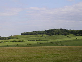
Grim's Ditch, Grim's Dyke or Grim's Bank is a name shared by a number of prehistoric bank and ditch earthworks. Enigmatic in both their naming and original function, examples are found across the chalk uplands of southern England.

The London–Aylesbury line is a railway line between London Marylebone and Aylesbury, going via the Chiltern Hills; passenger trains are operated by Chiltern Railways. Nearly half of the line is owned by London Underground, approximately 16 miles (26 km) – the total length of the passenger line is about 39 miles (63 km) with a freight continuation.

Grim's Ditch or Grim's Dyke or Grimes Dike is a great earthwork in the London Borough of Harrow and lends its name to the gentle escarpment it crowns, marking Hertfordshire's border. It extended east-west about 6 miles (9.7 km) from the edge of Stanmore where an elevated neighbourhood of London, Stanmore Hill, adjoins Bushey Heath to the far north of Pinner Green – Cuckoo Hill. Today the remaining earthworks start mid-way at Harrow Weald Common. It takes its name from the likely Roman Britain-era earthwork which became called one of seven Grim's Ditches, a few of which have two or three rows, in central-to-southern England.

Grim's Dyke is a house and estate in Harrow Weald, in northwest London, England. The house was built from 1870 to 1872 by Richard Norman Shaw for painter Frederick Goodall and named after the nearby prehistoric earthwork known as Grim's Ditch. It was converted into a hotel, Grim's Dyke Hotel, in 1970
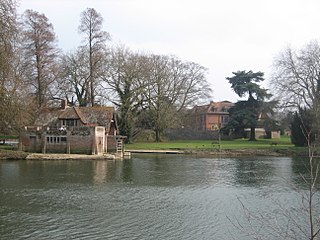
Mongewell is a village in the civil parish of Crowmarsh, about 1 mile (1.6 km) south of Wallingford in Oxfordshire. Mongewell is on the east bank of the Thames, linked with the west bank at Winterbrook by Winterbrook Bridge. The earthwork Grim's Ditch, now part of The Ridgeway long-distance footpath, passes through the northern part of it and is a scheduled ancient monument.
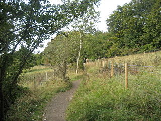
Aldbury Nowers is a 19.7 hectares biological Site of Special Scientific Interest (SSSI) in the Chiltern Hills, north-east of Tring in Hertfordshire. The site was notified in 1990 under the Wildlife and Countryside Act 1981. It is managed by the Hertfordshire and Middlesex Wildlife Trust. The site, formerly known as "Duchie's Piece," comprises two areas of hillside, linked by The Ridgeway. The calcareous meadow element of the site hosts the flowers of chalk grassland and has butterfly habitats with thirty-four different species of butterfly recently recorded, including the Duke of Burgundy, hairstreaks and the Essex skipper. The site also includes a "beech hanger", a type of upland ancient woodland, and is considered one of the best examples of this feature in Hertfordshire.
Knoll Camp, or Damerham Knoll, is the site of an Iron Age univallate hill fort located in Hampshire. The fort comprises a circular earthwork containing about four acres. There is a single ditch with inner rampart and traces of counter scarp bank. The site is a scheduled ancient monument no.118. Grim's Ditch also runs throughout this area. The footpath/bridleway from the nearby long barrows of Grans Barrow and Knap Barrow runs southeast along the ridge through the centre of the hill fort, leaving through the original SE entrance, and you could easily miss the ditch and bank as you cross it. The interior is thickly wooded and brambled.

Cholesbury Camp is a large and well-preserved Iron Age hill fort on the northern edge of the village of Cholesbury in Buckinghamshire, England. It is roughly oval-shaped and covers an area, including ramparts, of 15 acres (6.1 ha), and measures approximately 310 m (1,020 ft) north-east to south-west by 230 m (750 ft) north-west to south-east. The interior is a fairly level plateau which has been in agricultural use since the medieval period. The hill fort is now a scheduled ancient monument.

Pinner Green is a small area of Pinner, in the north-west of the London Borough of Harrow, 13.2 miles north-west of Charing Cross. It is a suburban area mostly occupied by family houses and flats, with a small parade of independent shops, a Tesco supermarket and a modern Shell forecourt.

Harrow Weald Common is an 18-hectare area of woodland, heath and pasture in Harrow Weald in the London Borough of Harrow. It is considered of considerable importance for wildlife, and it was formerly part of the Stanmore and Harrow Weald Commons and Bentley Priory Site of Special Scientific Interest, but in 1987 the boundaries of the SSSI were revised to exclude the Common. It has been designated by the Mayor of London as a Site of Metropolitan Importance for Nature Conservation.

Bradenham Woods, Park Wood and The Coppice is a 129.1 hectare biological Site of Special Scientific Interest in Bradenham in Buckinghamshire. It is in the Chilterns Area of Outstanding Natural Beauty, and it is described in A Nature Conservation Review. The site is part of the Bradenham Estate, which is owned by the National Trust. It is also designated a Special Area of Conservation. Grim's Ditch, a Scheduled Monument, runs through the site.

The Martin Down Enclosure is an archaeological site on Martin Down, near the village of Martin, in Hampshire, England. It is near the boundaries with Dorset and Wiltshire.