


The Grundloses Moor (literally: "Bottomless Bog") is the largest, virtually intact raised bog in the district of Heidekreis and a nature reserve in Walsrode in the German state of Lower Saxony.
The Grundloses Moor (literally: "Bottomless Bog") is the largest, virtually intact raised bog in the district of Heidekreis and a nature reserve in Walsrode in the German state of Lower Saxony.
The reserve has an area of 295 hectares (730 acres) and lies about 1.5 km west of the village of Ebbingen, 3.5 km north of the village of Fulde and five km northwest of the town of Walsrode.
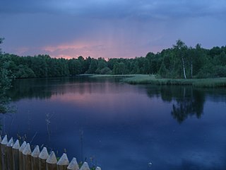
In the centre of the moor is the 2.5 metre deep lake Grundloser See, which is 435 metres long from north to south, and 160 metres wide in its northern part. It has an area of 4.7 hectares (12 acres) and lies at 72.5 metres (238 ft) above mean sea level. Roughly 400 metres to the northeast lies the Kleiner See ("Little Lake") with a diameter of about 60 metres.
The moor was formed in the northeastern half of a 4-kilometre-long depression enclosed by two parallel end moraines which were deposited during the Saalian glaciation. It is drained by a ditch that acts as the upper course of the Fulde. The Grundloser See was originally a residual ice age lake that had almost silted up. However, since then it has become a bog pond as a result of the build-up of peat moor and other processes.
The Grundloses Moor nature reserve is dominated by cottongrass, cranberries, bilberries, peat moss and cross-leaved heath. It was formerly used for peat cutting, especially in the south, but has regenerated itself after measures to raise the water levels were introduced.
It is possible to walk around the lake close to its shore setting out from hikers' car parks to the east (Ebbingen) and south (north of the Fulde). The lake is not suitable for bathing.
52°54′12.54″N9°33′0.48″E / 52.9034833°N 9.5501333°E
| | This Lower Saxony location article is a stub. You can help Wikipedia by expanding it. |
Shapwick Heath is a 394.0-hectare biological Site of Special Scientific Interest and national nature reserve between Shapwick and Westhay in Somerset, notified in 1967. It is part of the Brue Valley Living Landscape conservation project. The project commenced in January 2009 and aims to restore, recreate and reconnect habitat. It aims to ensure that wildlife is enhanced and capable of sustaining itself in the face of climate change while guaranteeing farmers and other landowners can continue to use their land profitably. It is one of an increasing number of landscape scale conservation projects in the UK.

Westhay Moor is a 513.7-hectare (1,269-acre) biological Site of Special Scientific Interest 2.5 kilometres (1.6 mi) north-east of Westhay village and 4 kilometres (2.5 mi) from Wedmore in Somerset, England, notified in 1971. Westhay Moor is also notified as part of the Somerset Levels and Moors Special Protection Area under the EU Birds Directive and as a Ramsar site, and a National Nature Reserve.

The Meißendorf Lakes and Bannetze Moor are a nature reserve and bird reserve of national importance on the edge of the Lüneburg Heath in the state of Lower Saxony in northern Germany. The special importance of this nature reserve is underlined by its recognition as a major federal nature reserve project. The area derives its name from the nearby villages of Meißendorf and Bannetze. The lakes were formerly a network of ponds established for fish-farming.

The Bullenkuhle is a predominantly marshy lake in the extreme north of the district of Gifhorn in the north German state of Lower Saxony. This strange biotope and geotope has been formed into a natural hollow in the terrain that is termed a sinkhole. The area is environmentally protected.

The Südheide Nature Park is a large protected area of forest and heathland in the southern part of the Lüneburg Heath in North Germany. It has been designated as a protected nature park since 1964.

The Großes Moor near Becklingen is a nature reserve in Germany with an area of 850 hectares, of which 666 hectares lie in Celle district and 184 hectares in Soltau-Fallingbostel district. Since 16 December 1985 the area has been protected under conservation law. An area of 776.6 hectares is designated as a special area of conservation (FFH-Gebiet). The name literally means "Large Bog near Becklingen" and it lies on the Lüneburg Heath, south of Wietzendorf and east of Becklingen, part of the borough of Bergen. The River Meiße has its source in this raised bog.

The Kiehnmoor is a nature reserve in Germany. It was designated as a nature reserve in 1992. It has an area of 440 hectares of which 100 hectares lie in Celle district and 340 hectares in Uelzen district. The nature conservation authorities of these districts are responsible for the reserve. A large part of the area is wet meadow, that in places is intensively farmed. However the majority of the area has been left in its natural state. A small sand heath forms part of the reserve. Its southern perimeter borders immediately on the larger heathland area of the Südheide Nature Park. The Heidschnucken, moorland sheep characteristic of the region, are reared here. North of the Kiehnmoor and immediately adjacent to it is the valley of a partially dammed stream, the Gerdau, and the Brambosteler Moor nature reserve. To the southeast the reserve borders on the Unterlüß Firing Range, belonging to the firm of Rheinmetall, and the Große Heide near Unterlüß, that is closed to the public. Kiehnmoor, too, is totally out-of-bounds. This whole area is very secluded. Rare birds have settled here including the crane and the black stork. Even the otter may be found here.
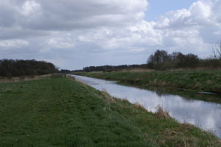
The Fulde is a river of Lower Saxony, Germany.
The Tiste Bauernmoor is an area of raised bog on the Lüneburg Heath in north Germany that was designated as a nature reserve on 2 May 2002. It has an area of 570 hectares and belongs, together with the Ekelmoor, Avensermoor and Everstofer Moor, to the large Ekelmoor moorland region that has a total area of 1,220 hectares.

The Bornrieth Moor is the remains of a raised bog in the German district of Celle and belongs to the Südheide Nature Park. It has an area of 115 hectares. The bog, which has had most of its peat extracted, was reflooded and placed under nature conservation protection in 1988. The moor was also designated as a Special Area of Conservation. The responsible nature conservation authority is the district of Celle. The area is out-of-bounds to the public. Several cranes have turned up here again and are breeding. The otherwise rare bog myrtle is common here. Much of the moor is covered by the common reed ('Phragmites'). Bog asphodel, cottongrass (Eriophorum) and sundews (Drosera) may also be found here.

The Großes Moor near Gifhorn is part of the Northwest German raised bog region, which stretches from the Netherlands to the eastern border of Lower Saxony on the sandy areas (geest) left behind by the ice age. The moor has a total area of about 6,100 hectares, of which around 5,000 hectares are raised bog and some 1,100 hectares are fen. The peat layer is up to almost 6 metres thick in places. Individual parts of the moor have their own names like Stüder Moor, Hestenmoor or Weißes Moor.


Ham Wall is an English wetland National Nature Reserve (NNR) 4 kilometres (2.5 mi) west of Glastonbury on the Somerset Levels. It is managed by the Royal Society for the Protection of Birds (RSPB). Since the last Ice Age, decomposing plants in the marshes of the Brue valley in Somerset have accumulated as deep layers of peat that were commercially exploited on a large scale in the twentieth century. Consumer demand eventually declined, and in 1994 the landowners, Fisons, gave their old workings to what is now Natural England, who passed the management of the 260 hectares Ham Wall section to the RSPB.
The Vehmsmoor is a nature reserve in North Germany. It is located in the borough of Walsrode within the district of Soltau-Fallingbostel in Lower Saxony. Its classification number is NSG LÜ 182.
The Oppenwehe Moor is a raised bog in the natural region of Diepholz Moor Depression in North Germany. It covers a total area of around 870 ha and lies in the northeastern part of the German state of North Rhine-Westphalia as well as in Lower Saxony. It is one of the most important bogs in Northwest Germany and is one of the ten most important wet meadow reserves in North Rhine-Westphalia. It is part of the Dümmer Nature Park.

Red Moor is a nature reserve and Site of Special Scientific Interest (SSSI), noted for its biological characteristics, near Lanlivery in mid Cornwall, England, UK.

The Georgenfelder Hochmoor is a raised bog (Hochmoor) in the German Ore Mountains of central Europe, not far from Zinnwald-Georgenfeld. It is part of a larger bog or moor complex, that lies to the south, mainly on the far side of the Germany's national border in the Czech Republic and which, since time immemorial, has been known simply as "The Lake". The Georgenfelder Hochmoor is one of the oldest nature reserves in Saxony.

The Ewiges Meer is the largest raised bog lake in Germany, with an area of 91 hectares. Its surface lies at about 8.5 metres above sea level (NN). The lake is surrounded by an extensive complex of unutilised areas, that exhibit the actual raised bog profile and, together with the lake, form the Ewiges Meer Nature Reserve which covers an area of 1,290 hectares.