Navantia is a Spanish state-owned shipbuilding company that builds vessels for the military and civil sectors. It is the fifth-largest shipbuilder in Europe and the ninth-largest in the world. The company is the result of the segregation of the military assets of the IZAR Group in 2005. The company designs, builds, and supports all types of surface vessels, submarines, and systems. In addition, it is diversifying into new markets such as renewable energy, the offshore industry, and naval services.

La Felguera is a parish of Langreo, and the most important district in the municipality of Langreo in northern Spain, with 21.000 inhabitants. It is located 18 minutes by car to Oviedo, the capital of Asturias. La Felguera is close to the Nalón River.

El Astillero is a town and municipality in the province and autonomous community of Cantabria, northern Spain. It is near the provincial capital of Santander, and it is known for its shipyard, and for hosting of Spanish national Rowing Championships. Its location is geographically defined by the estuaries that surround it. It is located between the municipalities of Camargo, Villaescusa, Piélagos, Medio Cudeyo and Marina de Cudeyo. Located at the foot of Peña Cabarga, is 7.5 kilometres away from the capital, Santander, and is 20 metres above sea level.
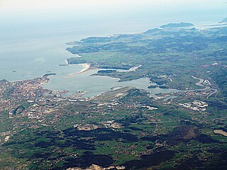
The Bay of Santander is both a comarca of Cantabria and the largest estuary on the North coast of Spain, with an extension of 22.42 km2. Due to the influence of Santander and its metropolitan area, nearly half of the population of the autonomous community of Cantabria is gathered around it, which makes the anthropic pressure on this area of water quite notable.

Valles Pasiegos is an administrative comarca in Cantabria, Spain. It is formed by the valleys of the Pas and Miera rivers, each one being a natural comarca of its own.

Sabero is a village in the province of León, Castile and León, in north-western Spain. According to the 2019 census (INE), the municipality has a population of 1,140 inhabitants.

Rabé de las Calzadas is a municipality and town located in the province of Burgos, Castile and León, Spain. According to the 2004 census (INE), the municipality had a population of 154 inhabitants.

Friera de Valverde is a municipality located in the province of Zamora, Castile and León, Spain. According to the 2009 census (INE), the municipality has a population of 227 inhabitants.
Pozaldez is a municipality located in the province of Valladolid, Castile and León, Spain. According to the 2004 census (INE), the municipality has a population of 497 inhabitants. The mayor is Eduardo Ibáñez Palacio and has been the mayor since 1991. The town has three significant monuments: two churches and 18th century fountain. A regionally and nationally known personality from Pozaldez was "Luisito de Pozaldez" known as the last jester. Pozaldez is also known for its wines. It is located on the Rueda region, and has great Verdejo wine.

Ouo is a department or commune of Comoé Province in southern Burkina Faso. Its capital lies at the town of Ouo. According to the 1996 census the department has a total population of 15,594.

The Rio Santiago Shipyard is a shipyard located in the city of Ensenada, Buenos Aires Province at the shores of the Santiago River. Currently owned by the Government of Buenos Aires Province, it has been one of the major active and important shipyards in Latin America. Founded in 1953, it has realized diverse functions in the naval, industrial and railroad sectors. In its golden age the shipyard reached 8,000 workers on double shift. In 2008 relies on 2,700 workers.
Cultural Deportiva Guarnizo is a Spanish football team based in Guarnizo, El Astillero, in the autonomous community of Cantabria. Founded in 1922, it plays in Tercera Federación – Group 3, holding home games at Estadio El Pilar, which has a capacity of 2,700 spectators.
A CHANT was a type of prefabricated coastal tanker which was built in the United Kingdom during the Second World War due to a perceived need for coastal tankers after the invasion of France. Some CHANTs were adapted to carry dry cargos. These were known as the Empire F type coasters.
Feleches is a parish in Siero, a municipality within the province and autonomous community of Asturias, in northern Spain.

Altar is a municipality in the Mexican state of Sonora in north-western Mexico. The municipality had a 2010 census population of 9,049 inhabitants, the vast majority of whom lived in the municipal seat of Altar, which had a population of 7,927 inhabitants. There are no other localities with over 1,000 inhabitants.
Drmanovići is a village in the municipality of Nova Varoš, western Serbia. According to the 2002 census, the village has a population of 368 people.

The Astilleros y Maestranzas de la Armada(English: Navy Shipyards and Armories), better known by the acronym ASMAR, is a Chilean state-owned shipbuilding company with autonomous administration, which provides services to the Chilean Navy, mainly, and also to other domestic and foreign customers. Its predecessor was Arsenales de Marina, created in 1895, until it was restructured and adopted its current name on April 6, 1960.

Sociedad Deportiva Unión Club de El Astillero was a Spanish football club based in El Astillero, in the autonomous community of Cantabria. Founded in 1922, the club played for 23 seasons in Tercera División.