Related Research Articles

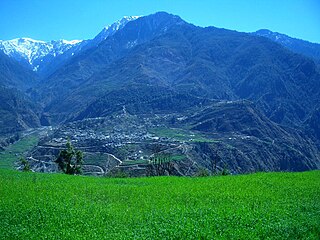
Mahakali was one of the fourteen zones located in the Far-Western Development Region of Nepal, covering an area of 6,205 km2 in the westernmost part of the country. It stretches along Nepal's far western border with India, marked by the Kali River or Mahakali River.
Bajura District, a part of Sudurpashchim Province, is one of the seventy-seven districts of Nepal. The district, with Martadi as its district headquarters, covers an area of 2,188 km2 (845 sq mi) and had a population of 108,781 in 2001 and 134,912 in 2011.

Chitwan District is one of 77 districts of Nepal, and takes up the southwestern corner of Bagmati Province. Bharatpur, largest city of Nepal after Kathmandu, is its administrative centre. It covers 2,238.39 km2 (864.25 sq mi), and in 2011 had a population of 579,984 people. Bharatpur is the commercial and service centre of South Central Nepal and a major destination for higher education, health care and transportation in the region. Chitwan lies in the Terai region of Nepal. It is in the drainage basin of the Gandaki River and is roughly triangular, taking that river as its meandering northwestern border, and a modest watershed border, with India, as the basis of its southern limit. Local government: Bharatpur Metropolitan, Rapti Municipality, Ratnanagar Municipality, Kalika Municipality, Khairahani Municipality, Madi Municipality, Ikshyakamana Gaupalika
Kanchanpur District, a part of Sudurpashchim Province in the Terai plain, is one of seventy-seven districts of Nepal. The district, with Bhimdatta as its district headquarters, covers an area of 1,610 square kilometres (620 sq mi) and had a population of 134,868 in 2001 and 171,304 in 2011. It is located in south-western of Nepal. It is bordered by Kailali district in the east, Dadeldhura district in the north and with India in the south and west.
Begampur is a census town in Chanditala II CD Block in Srirampore subdivision of Hooghly district in the state of West Bengal, India.

Garalgachha is a census town in Chanditala II CD Block in Srirampore subdivision in Hooghly district in the state of West Bengal, India.

Mahendranagar, officially known as Bhimdattanagar, is a municipality in Kanchanpur District of Sudurpashchim Province, Nepal. The city and the municipality were named Mahendranagar in honour of the late King Mahendra of Nepal. After becoming a republic in 2008, the Mahendranagar municipality name was changed to Bhimdatta municipality in honour of the revolutionary farmer leader Bhimdatta Panta. It is surrounded by Bedkot Municipality in the east, Dadeldhura District in the north, Shuklaphanta National Park in the south and Uttarakhand, India in the west.

Gulariya is a municipality and headquarters of Bardiya District in Lumbini Province of south-western Nepal. It is located in the plains of the Terai region near the southern border with the Bahraich district, Uttar Pradesh state of India. It is 35 kilometers west of Nepalgunj and about 10 km north of Murtiha Transit or railway station, India.
Mainapokhar is a village development committee in Bardiya District in Lumbini Province of south-western Nepal. At the time of the 1991 Nepal census it had a population of 6,841 and had 951 houses in the town. Now it reaches to nearly 20000 in 2016. It is nearly 20 km far from Nepalgunj.
Beldandi is a rural municipality in Kanchanpur District in Sudurpashchim Province of southwestern Nepal named after the former Village Development Committee. At the time of the 1991 Nepal census the VDC had a population of 9301 people living in 1483 individual households. According to the Nepal census 2011 the municipality had 3022 individual households and a population of 21,959. In the north and west, Beldandi is surrounded by Suklaphatha national park. To the east lies Belauri Municipality. On the south, it borders India.
Raikawar Bichawa is a village development committee in Kanchanpur District in the Mahakali Zone of south-western Nepal. At the time of the 1991 Nepal census it had a population of 9936 people living in 1391 individual households. There Are 9 Ward in Raikwar Bichawa VDC.
Mahakali, formerly Dodhara-Chandani, is a municipality in the Kanchanpur District of Sudurpashchim Province, in Nepal.
Nigali Band village is located in Krishnapur Municipality of Kanchanpur District. This place is 25 kilometres (16 mi) from Mahindranagar and 3 kilometres (1.9 mi) from Mahendra highway.
Krishnapur is a municipality in Kanchanpur District in Sudurpashchim Province of the far-western development region of Nepal. In the 2011 national census, there were 36,706 people living in 6,723 individual households. It was formed as municipality in 2015 by merger of Krishnapur VDC, Raikwar Bichwa VDC and part of Dekathbhuli VDC.
The Shree DiamondPublic Academy Higher Secondary School is a school in Gaddachauki, Nepal. It was founded in 1996 by Hira Chand when he was just 16 years old. At that time there was no English medium school in Gaddachauki.
Barahakshetra Municipality is a newly formed municipality located in Sunsari District of Koshi Province in Nepal. The area of the municipality is 222 km2 and according to 2021 Census of Nepal the population of the municipality is 91,087 Barahakshetra is a famous pilgrimage site that remains inside Barahakshetra Municipality. Also saptakoshi River flows inside the Municipality.
Pacharauta is a municipality in Bara District in Province No. 2 of South-Eastern Nepal. It was formed in 2016 occupying current 9 sections (wards) from previous 9 former VDCs. It occupies an area of 44.01 km2 with a total population of 34,175.
Kanchanpur 2 one of three parliamentary constituencies of Kanchanpur District in Nepal. This constituency came into existence on the Constituency Delimitation Commission (CDC) report submitted on 31 August 2017.
References
| | This section is empty. You can help by adding to it. (March 2016) |