
Gwernesney (Welsh : Gwernesni) is a village in Monmouthshire in southeast Wales.
Gwernesney (Welsh : Gwernesni) is a village in Monmouthshire in southeast Wales.
Gwernesney is located 3 miles (4.8 km) east of Usk on the B4235 road to Chepstow.
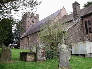
Gwernesney is set in a rural location close to Usk town. The former parish church in the village is St Michael and All Angels. The village also has a pub. The South Wales Gliding Club operate towed gliders from nearby - often to be seen over the village.
51°42′36″N2°50′53″W / 51.71000°N 2.84806°W
| | This article relating to a location in Monmouthshire is a stub. You can help Wikipedia by expanding it. |

Usk is a town and community in Monmouthshire, Wales, 10 miles (16 km) northeast of Newport. It is located on the River Usk, which is spanned by an arched stone bridge at the western entrance to the town. Usk Castle, above the town, overlooks the ancient crossing point. It developed as a small market town, with some industry including the making of Japanware, and with a notable prison built in 1841–42. In recent years, Usk has become known for its history of success in Britain in Bloom competitions, winning the "Wales in Bloom" competition 35 times in a row between 1982 and 2016. The resident population of the town in 2011 was 2,834, decreasing to roughly 2,600 in 2021. 6.8% of the population are recorded as being able to speak Welsh.
Uskmouth is an area to the south of the city of Newport, South Wales.

The Black Mountains are a group of hills spread across parts of Powys and Monmouthshire in southeast Wales, and extending across the England–Wales border into Herefordshire. They are the easternmost of the four ranges of hills that comprise the Brecon Beacons national park, and are frequently confused with the westernmost, which is known as the Black Mountain. The Black Mountains may be roughly defined as those hills contained within a triangle defined by the towns of Abergavenny in the southeast, Hay-on-Wye in the north and the village of Llangors in the west. Other gateway towns to the Black Mountains include Talgarth and Crickhowell. The range of hills is well known to walkers and ramblers for the ease of access and views from the many ridge trails, such as that on the Black Hill in Herefordshire, at the eastern edge of the massif. The range includes the highest public road in Wales at Gospel Pass, and the highest point in southern England at Black Mountain.

Kemeys Commander is a village in Monmouthshire, in South East Wales.
Llanbadoc is a village and community in the county of Monmouthshire and the preserved county of Gwent in Wales. The population of the village at the 2011 census was 806.
Llangybi is a village and community in Monmouthshire, in southeast Wales, in the United Kingdom. It is located 3 miles (4.8 km) south of the town of Usk and 5 miles (8 km) north of Caerleon, in the valley of the River Usk.
Bryngwyn is a village and rural location in Monmouthshire, south east Wales.

Newbridge-on-Usk is a hamlet in the village and parish of Tredunnock, near Usk, Monmouthshire, south east Wales, in the United Kingdom.
Llancayo is a village in Monmouthshire, south east Wales, United Kingdom. It is located two miles north of Usk on the B4598 road to Abergavenny, in the community of Gwehelog Fawr.

Llandegveth, also known by its Welsh name Llandegfedd, is a village in Monmouthshire, south east Wales. It is located between Cwmbran, in Torfaen, and Usk in rural Monmouthshire.

Llantrisant is a village in Monmouthshire, south east Wales, United Kingdom. The community population at the 2011 census was 475.
Llanwenarth is a small village and parish in the Usk Valley of Monmouthshire, south-east Wales, United Kingdom. It is in the community of Llanfoist Fawr and covered by the electoral ward of Llanwenarth Ultra.
Monkswood is a village in Monmouthshire, south east Wales, United Kingdom.

Llanllowell is a village in Monmouthshire, southeast Wales, in the United Kingdom. It is two miles southeast of Usk, in the community of Llantrisant Fawr.
Llanhennock is a village and former community, now in the community of Llangybi, in Monmouthshire, south east Wales, United Kingdom. The population taken at the 2011 census was 496. The village of Tredunnock was within the community. In 2022 the community was abolished and merged with Llangybi.
The Usk Inlier is a domed outcrop of rock strata of Silurian age in Monmouthshire in south-eastern Wales. It is located in the countryside between the towns of Caerleon and Pontypool and the village of Raglan. The longer axis of the dome or 'pericline', often referred to as the Usk Anticline, is aligned north–south. The inlier is largely surrounded by a sequence of Old Red Sandstone rocks of Devonian age, though both these and the Silurian rocks are largely obscured by superficial deposits.

Llanfrynach is a village and community in the county of Powys, Wales, and the historic county of Brecknockshire. The population of the community as taken at the 2011 census was 571. It lies just to the southeast of Brecon in the Brecon Beacons National Park. The village sits astride the Nant Menasgin, a right bank tributary of the River Usk. The B4558 passes just to its north and the Monmouthshire and Brecon Canal also passes around the village. The Welsh name signifies the 'church of Brynach'. The community includes the hamlets of Llanhamlach and Groesffordd.

National Cycle Route 88 is a route of the United Kingdom National Cycle Network, running from Newport to its planned finish site at Margam.

The Bryn, or Llangattock Nigh Usk, is a small village on the left bank of the River Usk in Monmouthshire, southeast Wales. It is accessed by a cul-de-sac minor road from the B4598 road, the reclassified former trunk road between Raglan and Abergavenny, now replaced by the modern A40 dual carriageway which runs east–west immediately north of the village. On the western edge of the village is St Cadoc's Church, a Gothic perpendicular style grade II* listed building probably dating from the fifteenth century. The village falls within the administrative community of Llanover. The Usk Valley Walk passes along the riverside path to the south.
The Berthin Brook is a minor right bank tributary of the River Usk in Monmouthshire, in south Wales. Flowing north from New Inn initially, it turns east at Little Mill to flow along a former glacial meltwater channel past the former Royal Ordnance Factory site at Glascoed and by Rhadyr to join the major river 1 km north of the town of Usk. At the height of the last ice age, the Usk valley glacier reached as far down the Usk valley as Little Mill and sediment-laden meltwater created a valley sandur over which the post-glacial Berthin Brook now flows.