Gâtine Vendéenne

Last updated

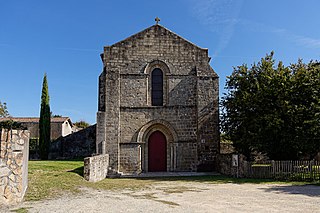
The Gâtine Vendéenne is a historical area in the west of France, around the town of Parthenay in the département of Deux-Sèvres. The area is hilly and wooded, distinguished by small fields and relatively poor land.

France Republic with mainland in Europe and numerous oversea territories

France, officially the French Republic, is a country whose territory consists of metropolitan France in Western Europe and several overseas regions and territories. The metropolitan area of France extends from the Mediterranean Sea to the English Channel and the North Sea, and from the Rhine to the Atlantic Ocean. It is bordered by Belgium, Luxembourg and Germany to the northeast, Switzerland and Italy to the east, and Andorra and Spain to the south. The overseas territories include French Guiana in South America and several islands in the Atlantic, Pacific and Indian oceans. The country's 18 integral regions span a combined area of 643,801 square kilometres (248,573 sq mi) and a total population of 67.3 million. France, a sovereign state, is a unitary semi-presidential republic with its capital in Paris, the country's largest city and main cultural and commercial centre. Other major urban areas include Lyon, Marseille, Toulouse, Bordeaux, Lille and Nice.

Parthenay Subprefecture and commune in Nouvelle-Aquitaine, France

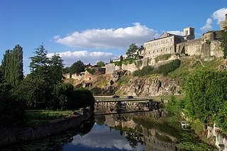
Parthenay is an ancient fortified town and commune in the Deux-Sèvres department of the Nouvelle-Aquitaine region in western France. It is sited on a rocky spur that is surrounded on two sides by the River Thouet, and is the sub-prefecture of the Parthenay arrondissement.

Deux-Sèvres Department of France

Deux-Sèvres is a French department. Deux-Sèvres literally means "two Sèvres": the Sèvre Nantaise and the Sèvre Niortaise are two rivers which have their sources in the department.

Several places in the Gâtine have names deriving from their location, including:

La Boissière-en-Gâtine Commune in Nouvelle-Aquitaine, France

La Boissière-en-Gâtine is a commune in the Deux-Sèvres department in the Nouvelle-Aquitaine region in western France.

Mazières-en-Gâtine Commune in Nouvelle-Aquitaine, France

Mazières-en-Gâtine is a commune in the Deux-Sèvres department in western France.

Saint-Paul-en-Gâtine Commune in Nouvelle-Aquitaine, France

Saint-Paul-en-Gâtine is a commune in the Deux-Sèvres department in western France.

Related Research Articles

Arctic Archipelago Canadian archipelago

The Arctic Archipelago, also known as the Canadian Arctic Archipelago, is a group of islands north of the Canadian mainland.

Fairland, Maryland census-designated place in Maryland, United States

Fairland is a census-designated place and an unincorporated area in Montgomery County, Maryland, United States.

Munising, Michigan City in Michigan, United States

Munising is a city on the southern shore of Lake Superior on the Upper Peninsula of the U.S. state of Michigan. The population was 2,355 at the 2010 census. It is the county seat of Alger County. The city is adjacent to the northwest corner of Munising Township, but is administratively autonomous.

Girard Township is a township in Otter Tail County, Minnesota, United States. The population was 697 at the 2000 census.

Haviland, New York Census-designated place in New York, United States

Haviland is a community and census-designated place (CDP) in Dutchess County, New York, United States. The population was 3,634 at the 2010 census. It is part of the Poughkeepsie–Newburgh–Middletown, NY Metropolitan Statistical Area as well as the larger New York–Newark–Bridgeport, NY-NJ-CT-PA Combined Statistical Area.

Camp A Lake is an unorganized territory in Saint Louis County, Minnesota, United States. The population was 16 at the 2000 census.

Potshot Lake is an unorganized territory in Saint Louis County, Minnesota, United States; located near Floodwood. The population was 73 at the 2000 census.

The arrondissement of Parthenay is an arrondissement of France in the Deux-Sèvres department in the Nouvelle Aquitaine region. It has 77 communes.

Adilly Commune in Nouvelle-Aquitaine, France

Adilly is a commune in the Deux-Sèvres department in the Nouvelle-Aquitaine region in western France. It is situated about 8 km (5.0 mi) northwest of the town of Parthenay.

Châtillon-sur-Thouet Commune in Nouvelle-Aquitaine, France

Châtillon-sur-Thouet is a village and commune in the Deux-Sèvres department of the Nouvelle-Aquitaine region in western France. The village is situated on the River Thouet to the north of the town of Parthenay, with which it forms a contiguous built-up area.

Champrond-en-Gâtine Commune in Centre-Val de Loire, France

Champrond-en-Gâtine is a commune in the Eure-et-Loir department in northern France.

The Communauté de communes de Parthenay-Gâtine is the communauté de communes, an intercommunal structure, centred on the town of Parthenay. It is located in the Deux-Sèvres department, in the Nouvelle-Aquitaine region, western France. It was created in January 2014 by the merger of the former Communauté de communes de Parthenay with 3 other former communautés de communes. Its population was 39,131 in 2014, of which 10,928 in Parthenay proper. It provides a framework within which local tasks common to the member communes can be carried out together. Amongst its other responsibilities, the communauté de communes organises the Festival Ludique International de Parthenay, a major games festival held in Parthenay every July.

The canton of La Gâtine is a canton located in the arrondissement of Parthenay, in the department of Deux-Sèvres, in the Nouvelle-Aquitaine region of France. It was created following the French canton reorganisation which came into effect in March 2015. It consists of 40 communes:

The canton of Nogent-le-Rotrou is an administrative division of the Eure-et-Loir department, northern France. Its borders were modified at the French canton reorganisation which came into effect in March 2015. Its seat is in Nogent-le-Rotrou.

The canton of Château-Renault is an administrative division of the Indre-et-Loire department, central France. Its borders were modified at the French canton reorganisation which came into effect in March 2015. Its seat is in Château-Renault.

The canton of Cerizay is an administrative division of the Deux-Sèvres department, western France. Its borders were modified at the French canton reorganisation which came into effect in March 2015. Its seat is in Cerizay.

References

    Coordinates: 46°39′N0°15′W / 46.65°N 0.25°W / 46.65; -0.25

    Geographic coordinate system Coordinate system

    A geographic coordinate system is a coordinate system that enables every location on Earth to be specified by a set of numbers, letters or symbols. The coordinates are often chosen such that one of the numbers represents a vertical position and two or three of the numbers represent a horizontal position; alternatively, a geographic position may be expressed in a combined three-dimensional Cartesian vector. A common choice of coordinates is latitude, longitude and elevation. To specify a location on a plane requires a map projection.