Güntersburg

Last updated
Foundation walls Guentersburg 134119.jpg
Foundation walls

The ruined castle of Güntersburg stands about 2 km (1.2 mi) southwest of Güntersberge in the Harz mountain range of central Germany. [1]

Güntersberge Locality of Harzgerode in Saxony-Anhalt, Germany

Güntersberge is a village and a former town in Harz District, in Saxony-Anhalt, Germany. It holds the status of an officially recognized resort town since 2001. Güntersberge, together with the other municipalities of the former Verwaltungsgemeinschaft Unterharz, merged into the town of Harzgerode as of 1 August 2009.

Harz Low mountain range in northern Germany

The Harz is a Mittelgebirge that has the highest elevations in Northern Germany and its rugged terrain extends across parts of Lower Saxony, Saxony-Anhalt, and Thuringia. The name Harz derives from the Middle High German word Hardt or Hart, Latinized as Hercynia. The Brocken is the highest summit in the Harz with an elevation of 1,141.1 metres (3,744 ft) above sea level. The Wurmberg is the highest peak located entirely within the state of Lower Saxony.

Germany Federal parliamentary republic in central-western Europe

Germany, officially the Federal Republic of Germany, is a country in Central and Western Europe, lying between the Baltic and North Seas to the north, and the Alps to the south. It borders Denmark to the north, Poland and the Czech Republic to the east, Austria and Switzerland to the south, France to the southwest, and Luxembourg, Belgium and the Netherlands to the west.

Condition

The ruins are located on the 485 m (1,591 ft) Kohlberg hill above the Selke valley. The castle site is very large and has an area of about 3 hectares (7.4 acres). It probably included a fortified settlement, possibly preceding modern Güntersberge, beside the proper castle. To the northwest the site was protected by a rampart and a 150 m (490 ft) long ditch, whose scale can still be easily made out today. To the southeast the site is bounded by the hillside that falls steeply into the Selke valley.

Selke (river) tributary of the River Bode in Saxony-Anhalt, Germany

The Selke is a river of Saxony-Anhalt, Germany.

Defensive wall Fortification used to protect an area from potential aggressors

A defensive wall is a fortification usually used to protect a city, town or other settlement from potential aggressors. In ancient to modern times, they were used to enclose settlements. Generally, these are referred to as city walls or town walls, although there were also walls, such as the Great Wall of China, Walls of Benin, Hadrian's Wall, Anastasian Wall, the Cyclopean Wall Rajgir and the metaphorical Atlantic Wall, which extended far beyond the borders of a city and were used to enclose regions or mark territorial boundaries. In mountainous terrain, defensive walls such as letzis were used in combination with castles to seal valleys from potential attack. Beyond their defensive utility, many walls also had important symbolic functions – representing the status and independence of the communities they embraced.

Moat dry or watery ditch surrounding a fortification or town

A moat is a deep, broad ditch, either dry or filled with water, that is dug and surrounds a castle, fortification, building or town, historically to provide it with a preliminary line of defence. In some places moats evolved into more extensive water defences, including natural or artificial lakes, dams and sluices. In older fortifications, such as hillforts, they are usually referred to simply as ditches, although the function is similar. In later periods, moats or water defences may be largely ornamental. They could also act as a sewer.

Of the former buildings only a few foundation walls are recognisable. Still easy to make out are the foundation walls of the two gatehouse towers. Little is known of its history. The castle was probably built in the 11th century. [1] First mentioned around 1326, the site was already recorded as devastated by about 1600. Among its former owners were the Lords of Kneitlingen and the Counts of Stolberg.

Tower structure with height greater than width

A tower is a tall structure, taller than it is wide, often by a significant margin. Towers are distinguished from masts by their lack of guy-wires and are therefore, along with tall buildings, self-supporting structures.

Kneitlingen Place in Lower Saxony, Germany

Kneitlingen is a municipality in the Wolfenbüttel district in the German state of Lower Saxony. It is part of the Samtgemeinde Elm-Asse. The most recent German census counted a population of just 853 people.

County of Stolberg

The County of Stolberg was a county of the Holy Roman Empire located in the Harz mountain range in present-day Saxony-Anhalt, Germany. It was ruled by a branch of the House of Stolberg.

According to legend, the castle was occupied by robber barons at last and one of their victims, the daughter of a merchant, is still supposed to appear as a white apparition today to those venturing near to the castle at night. [1] The bunch of keys she carries with her was once supposed to had brought a curse on a monk.

Robber baron (feudalism) unscrupulous feudal landowner who resorted to banditry while protected by his fiefs legal status

A robber baron or robber knight was an unscrupulous feudal landowner who imposed high taxes and tolls out of keeping with the norm without authorization by some higher authority, while protected by his fief's legal status. Some resorted to actual banditry. Medieval robber barons most often imposed high or unauthorized tolls on rivers or roads passing through their territory. Some actually robbed merchants, land travelers, and river traffic, seizing money, cargoes, entire ships, or engaged in kidnapping for ransom.

Related Research Articles

Château de Langeais castle

The Château de Langeais is a medieval castle in Indre-et-Loire, France, built on a promontory created by the small valley of the Roumer River at the opening to the Loire Valley. Founded in 992 by Fulk Nerra, Count of Anjou, the castle was soon attacked by Odo I, Count of Blois. After the unsuccessful attack, the now-ruined stone keep was built; it is one of the earliest datable stone examples of a keep. Between 994 and 996 the castle was besieged unsuccessfully twice more. During the conflict between the counts of Anjou and Blois, the castle changed hands several times, and in 1038 Fulk captured the castle again.

Selke Valley Railway railway line

The Selke Valley Railway (Selketalbahn), Gernrode-Harzgerode Railway and the Anhalt Harz Railway were different names for the metre gauge railway in the Lower Harz, Germany, originally owned by the Gernrode-Harzgerode Railway Company.

Harzgerode Place in Saxony-Anhalt, Germany

Harzgerode is a town in the district of Harz in Saxony-Anhalt, Germany.

Güssenburg Castle castle

Güssenburg Castle is a ruined castle on a hill near Hermaringen in Heidenheim County in Baden-Württemberg, Germany. It was built around 1346, during the High Middle Ages and much of the curtain wall and keep remain.

Kaltenburg Castle castle

Kaltenburg Castle is a ruined castle, located in the Lonetal between the cities of Giengen and Niederstotzingen in the district of Heidenheim, Baden-Württemberg, Germany. The castle was built during the High Middle Ages and though ruined, most of the walls are intact.

Lojsta Castle

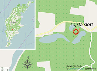
Lojsta Castle in Stånga socken on the border of Lojsta, Gotland, Sweden, is, despite its name, not a "castle" in the normal sense, i.e. it is not a palacelike manor. It is the ruins of a once fortified estate, consisting of houses surrounded by a wall and a moat.

Heinrichsberg Castle castle

Heinrichsberg Castle is a ruin north of Mägdesprung in the borough of Harzgerode in central Germany. It is not far from the B 185 federal road in the district of Harz in the state of Saxony-Anhalt.

Konradsburg

The Konradsburg is a former castle, monastery and manor house near Ermsleben in the German federal state of Saxony-Anhalt.

Katzsohlteich

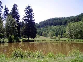
The Katzsohlteich is an artificially impounded reservoir that lies southwest of the town of Güntersberge in the Harz Mountains of central Germany and is used as a preflooder (Vorfluter) and fishpond. Only a few metres from the pond is the considerably larger lake of Bergsee, past the southern shores of which runs the Selke Valley Railway.

Hochjuvalt Castle ruins in Switzerland

Hochjuvalt Castle is a castle in the municipality of Rothenbrunnen of the Canton of Graubünden in Switzerland. It is a Swiss heritage site of national significance.

Fracstein Castle

Fracstein Castle is a castle in the municipality of Seewis im Prättigau of the Canton of Graubünden in Switzerland. It is a Swiss heritage site of national significance.

Ackeburg castle

The Ackeburg, also called the Ackenburg, in the Harz Mountains of central Germany, is the site of a high medieval hill castle, 333.2 m above sea level (NN), in the borough of Falkenstein/Harz in Harz district in the state of Saxony-Anhalt. It was first mentioned in 1216 and was abandoned or destroyed in 1400. There was also a village associated with it, known as Akkeburg.

Old Falkenstein Castle castle

Old Falkenstein Castle in the Harz Mountains of Germany is the castle site or burgstall of a high medieval hill castle. It lies on the territory of Falkenstein/Harz in the state of Saxony-Anhalt in the district of Harz. It was built in the 11th century A.D. and destroyed in 1115.

Tece Castle

Tece Castle is a ruined castle in Mersin Province, southern Turkey.

Schlüsselstein Castle castle

Schlüsselstein Castle was a castle and the seat of a noble family, probably dating to the High Middle Ages, the remains of which lie above the town of Ebermannstadt in the Upper Franconian county of Forchheim in the south German state of Bavaria. The site is known locally as Burgstall Schlüsselstein.

Cagliatscha Castle A ruined castle in the municipality of Andeer in the canton of Graubünden in Switzerland

Cagliatscha Castle German: Burg Cagliatscha is a ruined castle in the municipality of Andeer in the Viamala Region of the canton of Graubünden in Switzerland.

Serviezel Castle

Serviezel Castle is a pair of ruined castles in the municipality of Valsot of the Canton of Graubünden in Switzerland. Very little is known about either castle and they were probably both built in the 12th century for the Lords of Ramosch. Serviezel (Ramosch) is located in the former municipality of Ramosch, while Serviezel (Tschlin) is about 6.1 km (3.8 mi) away in the former municipality of Tschlin.

Canaschal Castle

Canaschal Castle is a pair of ruined castles near Trin, Canton of Graubünden, Switzerland.

References

  1. 1 2 3 Die Burgruine Güntersburg at www.harzlife.de. Accessed on 5 Dec 2010.

Coordinates: 51°38′16.3″N10°58′15.4″E / 51.637861°N 10.970944°E / 51.637861; 10.970944

Geographic coordinate system Coordinate system

A geographic coordinate system is a coordinate system that enables every location on Earth to be specified by a set of numbers, letters or symbols. The coordinates are often chosen such that one of the numbers represents a vertical position and two or three of the numbers represent a horizontal position; alternatively, a geographic position may be expressed in a combined three-dimensional Cartesian vector. A common choice of coordinates is latitude, longitude and elevation. To specify a location on a plane requires a map projection.