
Dupont Circle is a traffic circle, park, neighborhood, and historic district in Northwest Washington, D.C. The Dupont Circle neighborhood is bounded approximately by 16th Street NW to the east, 22nd Street NW to the west, M Street NW to the south, and Florida Avenue NW to the north. Much of the neighborhood is listed on the National Register of Historic Places. However, the local government Advisory Neighborhood Commission and the Dupont Circle Historic District have slightly different boundaries.

Washington Union Station is a major train station, transportation hub, and leisure destination in Washington, D.C. Opened in 1907, it is Amtrak's headquarters and the railroad's second-busiest station with annual ridership of just under 5 million and the ninth-busiest in overall passengers served in the United States. The station is the southern terminus of the Northeast Corridor, an electrified rail line extending north through major cities including Baltimore, Philadelphia, New York City, and Boston and the busiest passenger rail line in the nation.
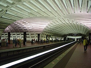
Metro Center station is the central hub station of the Washington Metro rapid transit system in Washington, D.C. The station is located in downtown Washington, centered on the intersection of 12th Street NW and G Street NW. It is the second busiest station in the Metrorail system after Union Station, averaging 30,500 passengers per weekday as of May 2006. The Red Line portion of Metro Center station opened on March 27, 1976, as part of the first section of the Metro system.
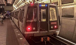
The Blue Line is a rapid transit line of the Washington Metro system, consisting of 27 stations in Fairfax County, Alexandria and Arlington, Virginia; the District of Columbia; and Prince George's County, Maryland, United States. The Blue Line runs from Franconia–Springfield to Largo Town Center. The line shares tracks with the Orange Line for 13 stations, the Silver Line for 18, and the Yellow Line for six. Only three stations are exclusive to the Blue Line.

The Green Line is a rapid transit line of the Washington Metro system, consisting of 21 stations in the District of Columbia and Prince George's County, Maryland, United States. The Green Line runs from Branch Avenue to Greenbelt. It was the last line in the original Metrorail plan to be constructed, and is one of three north–south lines through the city of Washington. The Green Line shares tracks with the Yellow line from L'Enfant Plaza to Greenbelt.

Gallery Place is a Washington Metro station in Washington, D.C., United States, on the Green, Red and Yellow Lines. It is a transfer station between the Red Line on the upper level and the Green/Yellow Lines on the lower level.

L'Enfant Plaza is an intermodal transit station located at L'Enfant Plaza in the Southwest Federal Center neighborhood of Washington, D.C.. It consists of an underground Washington Metro rapid transit station and an elevated Virginia Railway Express commuter rail station.

Anacostia is a Washington Metro station in Washington, D.C. on the Green Line. The station is located in the Anacostia neighborhood of Southeast Washington, with entrances at Shannon Place and Howard Road near Martin Luther King, Jr. Avenue SE. The station serves as a hub for Metrobus routes in Southeast, Washington, D.C. and Prince George's County, Maryland.

K Street is a major thoroughfare in the United States capital of Washington, D.C. known as a center for numerous lobbyists and advocacy groups. In political discourse, "K Street" has become a metonym for Washington's lobbying industry since many lobbying firms were traditionally located on the section in Northwest Washington which passes from Georgetown through a portion of Downtown D.C. Since the late 1980s, however, many of the largest lobbying firms have moved out; as of 2012, only one of the top-20 lobbying firms has a K Street address.

Northeast is the northeastern quadrant of Washington, D.C., the capital of the United States. It encompasses the area located north of East Capitol Street and east of North Capitol Street.

Forest Hills is a residential neighborhood in the northwest quadrant of Washington, D.C., United States, bounded by Connecticut Avenue NW to the west, Rock Creek Park to the east, Chevy Chase to the north, and Tilden Street NW to the south. The neighborhood is frequently referred to as Van Ness, both because of its proximity to the University of the District of Columbia (UDC)'s Van Ness campus, and because it is served by the Van Ness–UDC station on the Washington Metro's Red Line.

Kowloon Tong is a station on MTR's Kwun Tong line and East Rail line in New Kowloon, Hong Kong. The station serves Kowloon Tong and its vicinity, including Yau Yat Tsuen, the Festival Walk shopping centre, City University of Hong Kong and Hong Kong Baptist University.

The C branch, also called the Beacon Street Line or Cleveland Circle Line, is one of four branches of the Massachusetts Bay Transportation Authority's Green Line light rail system in the Boston, Massachusetts metropolitan area. The line begins at Cleveland Circle in the Brighton neighborhood of Boston and runs on the surface through Brookline along the median of Beacon Street. Reentering Boston, the line goes underground through the St. Marys Street incline and joins the B and D branches at Kenmore. Trains run through the Boylston Street subway to Copley where the E branch joins, then continue through the Tremont Street subway to downtown Boston. As of 2020, the C branch terminates at North Station.

Massachusetts Avenue is a major diagonal transverse road in Washington, D.C., and the Massachusetts Avenue Historic District is a historic district that includes part of it.

Connecticut Avenue is a major thoroughfare in the Northwest quadrant of Washington, D.C., and suburban Montgomery County, Maryland. It is one of the diagonal avenues radiating from the White House, and the segment south of Florida Avenue was one of the original streets in Pierre (Peter) Charles L'Enfant's plan for Washington.

Wisconsin Avenue is a major thoroughfare in Washington, D.C., and its Maryland suburbs. The southern terminus begins in Georgetown just north of the Potomac River, at an intersection with K Street under the elevated Whitehurst Freeway. The section of Wisconsin Avenue in Georgetown was called High Street before the street names in Georgetown were changed in 1895 to conform to those of the L'Enfant plan for the federal city.

For other uses, see H Street (disambiguation)

Near Northeast is a neighborhood in Northeast Washington, D.C. It is bounded by North Capitol Street to the west, Florida Avenue to the north, F Street to the south, and 15th Street to the east.

The DC Streetcar is a surface streetcar network in Washington, D.C. As of 2017, it consists of only one line: a 2.2-mile segment running in mixed traffic along H Street and Benning Road in the city's Northeast quadrant.

The H Street/Benning Road Line is a currently operating line of DC Streetcar. It has eight stations and began operation on February 27, 2016. The 2.4-mile (3.9 km) line runs along H Street NE and Benning Road NE in Washington, D.C.. In September 2016 service was increased from six days a week to seven, and with shorter 12-minute headways.