
Cuxhaven is a town and seat of the Cuxhaven district, in Lower Saxony, Germany. The town includes the northernmost point of Lower Saxony. It is situated on the shore of the North Sea at the mouth of the Elbe River. Cuxhaven has a footprint of 14 kilometres (east–west) by 7 km (4 mi) (north–south). Its town quarters Duhnen, Döse and Sahlenburg are especially popular vacation spots on the North Sea and home to about 52,000 residents.

The Province of Hanover was a province of the Kingdom of Prussia and the Free State of Prussia from 1868 to 1946.

Otterndorf is a town on the coast of the North Sea in the federal state of Lower Saxony, Germany, and is part of the collective municipality of Land Hadeln. The town, located in the administrative district of Cuxhaven, is at the mouth of the river Medem, part of the Elbe delta. The old town centre (Altstadt) features a number of half-timbered houses.
Neuenkirchen can refer to several municipalities in Germany:
Am Dobrock is a former Samtgemeinde in the district of Cuxhaven, in Lower Saxony, Germany. It is situated near the confluence of the rivers Oste and Elbe, approx. 25 km east of Cuxhaven, and 15 km south of Brunsbüttel. Its seat is in the village Cadenberge. On 1 November 2016 it was merged into the Samtgemeinde Land Hadeln.

Land Wursten is a former Samtgemeinde in the district of Cuxhaven, in Lower Saxony, Germany. It was situated approximately 20 km (12 mi) southwest of Cuxhaven, and 15 km (9.3 mi) north of Bremerhaven. Its seat was in the village Dorum. It was disbanded in January 2015, when its member municipalities merged into the new municipality Wurster Nordseeküste.

Sietland is a former Samtgemeinde in the district of Cuxhaven, in Lower Saxony, Germany. It was situated in the historical Land of Hadeln approx. 20 km southeast of Cuxhaven. Its seat was in the village Ihlienworth. On 1 January 2011 it merged with the Samtgemeinde Hadeln to form the new Samtgemeinde Land Hadeln.

Ihlienworth is a municipality in the district of Cuxhaven, in Lower Saxony, Germany.

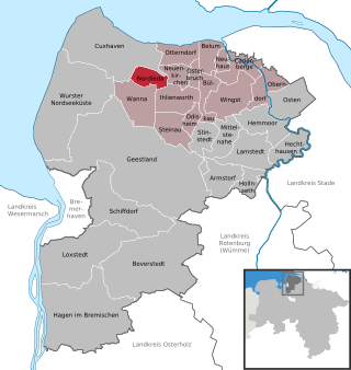
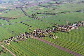
Neuenkirchen is a municipality in the Land Hadeln collective municipality within the district of Cuxhaven, in Lower Saxony, Germany.
Nordleda is a municipality in the district of Cuxhaven, in Lower Saxony, Germany.
Odisheim is a municipality in the district of Cuxhaven, in Lower Saxony, Germany.

Osterbruch is a municipality in the district of Cuxhaven, in Lower Saxony, Germany.

Steinau in the Land of Hadeln is a municipality in the district of Cuxhaven, in Lower Saxony, Germany.
The Stade Region emerged in 1823 by an administrative reorganisation of the dominions of the Kingdom of Hanover, a sovereign state, whose then territory is almost completely part of today's German federal state of Lower Saxony. Until 1837 the Kingdom of Hanover was ruled in personal union by the Kings of the United Kingdom of Great Britain and Ireland.

The region between the Elbe and Weser rivers forms the Elbe–Weser triangle, also rendered Elbe-Weser Triangle, in northern Germany. It is also colloquially referred to as the Nasses Dreieck or "wet triangle".
Land Hadeln is a historic landscape and former administrative district in Northern Germany with its seat in Otterndorf on the Lower Elbe, the lower reaches of the River Elbe, in the Elbe-Weser Triangle between the estuaries of the Elbe and Weser.
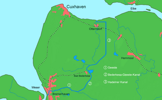
The Elbe–Weser waterway or Elbe–Weser shipping channel is a short-cut between the rivers Elbe and Weser in North Germany which is part-canal and part-river. It has a length of 54.7 kilometres (34.0 mi) and is designed for smaller coastal vessels. It includes some 60 kilometres (37 mi) of canal dykes and 45 kilometres (28 mi) of canal paths. The channel starts in Otterndorf with the Hadeln Canal, then becomes the Bederkesa-Geeste Canal from the town of Bad Bederkesa to the River Geeste, the final leg of the shipping channel, which flows into the Weser at Bremerhaven. It is owned by the state of Lower Saxony, maintained by the NLWKN from its Stade office. Today they just look after maintenance of the drainage system, because the economic element of the canal – commercial shipping which was particularly thriving in the late 1960s – declined increasingly from 1973 onwards and today hardly exists at all. Nevertheless, the waterway is still used by smaller yachts as a short cut between Elbe and Weser.

Land Hadeln is a Samtgemeinde in the district of Cuxhaven, in Lower Saxony, Germany. Its seat is in the town Otterndorf. It was formed on 1 January 2011 by the merger of the former Samtgemeinden Hadeln and Sietland. On 1 November 2016 the Samtgemeinde Am Dobrock was merged into Land Hadeln.

Cuxland, in a tourist sense, is the land between the River Weser and the mouth of the Elbe in the district of Cuxhaven on Germany's North Sea coast.


