Gustav III's Pavilion is a royal pavilion at the Haga Park, 2 km north of Stockholm. As a highlight in Swedish art history, the Pavilion is a fine example of the European neoclassicism of the late 18th century in Northern Europe. Beside the Pavilion lie the "Sultan's Copper Tents", buildings designed to resemble big tents.

Morianbron is a small bridge in the gardens of the Ulriksdal Palace in Solna, Sweden, named after the pair of sculptures of so-called blackamoors standing by the bridge.
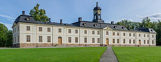
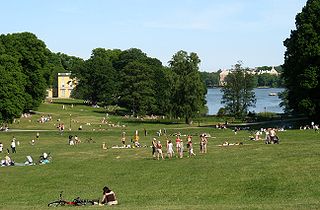
Svartsjö Palace is a Rococo palace situated in Svartsjö on the island of Färingsö in lake Mälaren. It is a 30-minute car ride from Stockholm, the capital of Sweden.
Paparzyn is a village in the administrative district of Gmina Stolno, within Chełmno County, Kuyavian-Pomeranian Voivodeship, in north-central Poland.

Suleyman is a village in the Absheron Rayon of Azerbaijan.
Qışlaq is a village in the Jabrayil Rayon of Azerbaijan.
Xələc is a village in the Qubadli Rayon of Azerbaijan.

Kużaj is a village in the administrative district of Gmina Galewice, within Wieruszów County, Łódź Voivodeship, in central Poland. It lies approximately 5 kilometres (3 mi) north-east of Galewice, 14 km (9 mi) north-east of Wieruszów, and 93 km (58 mi) south-west of the regional capital Łódź.

Asari Dam (朝里ダム) is a dam in Otaru, Hokkaidō, Japan, completed in 1993. It is a Gravity dam of 73.9m which is currently managed by the Hokkaido Construction Department. The man-made lake which resulted from the construction of the dam is called Otarunai Lake.
Szadek-Kolonia is a village in the administrative district of Gmina Blizanów, within Kalisz County, Greater Poland Voivodeship, in west-central Poland.
Słomówko is a village in the administrative district of Gmina Września, within Września County, Greater Poland Voivodeship, in west-central Poland. It lies approximately 5 kilometres (3 mi) north-west of Września and 44 km (27 mi) east of the regional capital Poznań.
Miechucińskie Chrósty is a settlement in the administrative district of Gmina Chmielno, within Kartuzy County, Pomeranian Voivodeship, in northern Poland. It lies approximately 4 kilometres (2 mi) west of Chmielno, 11 km (7 mi) west of Kartuzy, and 39 km (24 mi) west of the regional capital Gdańsk.
Garczyn is a village in the administrative district of Gmina Liniewo, within Kościerzyna County, Pomeranian Voivodeship, in northern Poland. It lies approximately 4 kilometres (2 mi) south of Liniewo, 19 km (12 mi) south-east of Kościerzyna, and 45 km (28 mi) south-west of the regional capital Gdańsk.
Czarna Góra is a settlement in the administrative district of Gmina Szemud, within Wejherowo County, Pomeranian Voivodeship, in northern Poland. It lies approximately 9 kilometres (6 mi) east of Szemud, 16 km (10 mi) south-east of Wejherowo, and 22 km (14 mi) north-west of the regional capital Gdańsk.
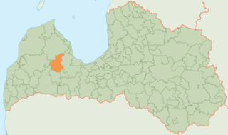
Kandava Municipality is a municipality in Courland, Latvia. The municipality was formed in 1999 by merging Cēre parish and Kandava town with its countryside territory. Later it absorbed Matkule parish, Vāne parish, Zante parish and Zemīte parish the administrative centre being Kandava.
Bảo Đài is a commune (xã) and village in Lục Nam District, Bắc Giang Province, in northeastern Vietnam.
Bordj Ben Azzouz is a town and commune in Biskra Province, Algeria. According to the 1998 census it has a population of 11,043.

Taračin Do is a village in the municipality of Ilijaš, Bosnia and Herzegovina.

Minzhi station is on Line 5 of the Shenzhen Metro. It opened on 22 June 2011.