Tropical Storm Karen may refer to:

The 2007 Pacific typhoon season was a below average season which featured 24 named storms, fourteen typhoons, and five super typhoons. It was an event in the annual cycle of tropical cyclone formation, in which tropical cyclones form in the western Pacific Ocean. The season ran throughout 2007, though most tropical cyclones typically develop between May and November. The season's first named storm, Kong-rey, developed on March 30, while the season's last named storm, Mitag, dissipated on November 27. The season's first typhoon, Yutu, reached typhoon status on May 18, and became the first super typhoon of the year on the next day.

The 2002 Pacific typhoon season was an slightly above average Pacific typhoon season, producing twenty-six named storms, fifteen becoming typhoons, and eight super typhoons. It was an event in the annual cycle of tropical cyclone formation, in which tropical cyclones form in the western Pacific Ocean. The season ran throughout 2002, though most tropical cyclones typically develop between May and October. The season's first named storm, Tapah, developed on January 11, while the season's last named storm, Bolaven, dissipated on December 11. The season's first typhoon, Mitag, reached typhoon status on March 1, and became the first super typhoon of the year four days later.
This timeline documents all events that have taken place during the 2007 Pacific typhoon season. This article is limited to the Western Pacific basin which is located north of the equator and between 100°E and the International Date Line. Systems that reach tropical storm intensity are assigned a name by the Japan Meteorological Agency (JMA). Tropical depressions that form within the basin are assigned a number with a "W" suffix by the Joint Typhoon Warning Center (JTWC). Additionally, the Philippine Atmospheric, Geophysical and Astronomical Services Administration (PAGASA) assigns names to tropical cyclones that either form in or move into its self defined area of responsibility, which runs from 135°E to 115°E and 5°N to 25°N.
The name Hagibis has been used to name four tropical cyclones in the western north Pacific Ocean. The name was contributed by the Philippines and means "rapidity", "swiftness", or "the sound or sensation perceived when something passes by rapidly."

Typhoon Mitag, known in the Philippines as Typhoon Mina, was a strong typhoon that caused deadly flooding in the Philippines in November 2007.
The 2009 Pacific typhoon season was a below average season that spawned only 22 named storms, 13 typhoons, and five super typhoons. It was also recognized as the deadliest season in the Philippines for decades. The first half of the season was very quiet whereas the second half of the season was extremely active. The season's first named storm, Kujira, developed on May 3 while the season's last named storm, Nida, dissipated on December 3.

The 2014 Pacific typhoon season was a slightly below average season, featuring 23 tropical storms, 11 typhoons, 8 super typhoons, and 7 Category 5 typhoons. The season's peak months August and September saw minimal activity caused by an unusually strong and a persistent suppressing phase of the Madden–Julian oscillation (MJO). The season ran throughout 2014, though most tropical cyclones typically develop between May and October. The season began with the development of Tropical Storm Lingling on January 18, and ended after Tropical Storm Jangmi which dissipated on January 1 of the next year.

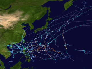
The 2019 Pacific typhoon season was the costliest Pacific typhoon season on record, just ahead of the previous year. The season was fairly above-average, producing 29 named storms, 17 typhoons, and five super typhoons. It was an event in the annual cycle of tropical cyclone formation, in which tropical cyclones form in the western Pacific Ocean. The season ran throughout 2019, though most tropical cyclones typically develop between May and October. The season's first named storm, Pabuk, reached tropical storm status on January 1, becoming the earliest-forming tropical storm of the western Pacific Ocean on record, breaking the previous record that was held by Typhoon Alice in 1979. The season's first typhoon, Wutip, reached typhoon status on February 20. Wutip further intensified into a super typhoon on February 23, becoming the strongest February typhoon on record, and the strongest tropical cyclone recorded in February in the Northern Hemisphere. The season's last named storm, Phanfone, dissipated on December 29 after it made landfall in the Philippines. The accumulated cyclone energy (ACE) index of this season amounted to 269 units.
The name Lando has been used in the Philippines by PAGASA in the Western Pacific. It was previously known as Lakay where it was used in 2003 Pacific typhoon season.

Tropical Storm Cimaron, known in the Philippines as Tropical Storm Isang, was a weak tropical storm, with only a pressure of 1000 hectopascals and 45 mph, it formed and made landfall in the Philippines, especially Luzon, and China, as well as affecting Southern Taiwan during its nearby passage. Despite being weak, the storm still caused extensive damage amounting to approximately $325 million in China, as well as 6 deaths in total, with 2 in the Philippines.
This timeline documents all of the events of the 2014 Pacific typhoon season. Most of the tropical cyclones forming between May and November. The scope of this article is limited to the Pacific Ocean, north of the equator between 100°E and the International Date Line. Tropical storms that form in the entire Western Pacific basin are assigned a name by the Japan Meteorological Agency. Tropical depressions that form in this basin are given a number with a "W" suffix by the United States' Joint Typhoon Warning Center. In addition, the Philippine Atmospheric, Geophysical and Astronomical Services Administration (PAGASA) assigns names to tropical cyclones that enter or form in the Philippine area of responsibility. These names, however, are not in common use outside of the Philippines.

Tropical Storm Hagibis was a tropical storm that, along with the southwest monsoon, brought heavy rainfall to the Philippines for nearly a week in June 2014. The storm formed on June 13 and dissipated on June 18. Hagibis made landfall on June 15, causing damage estimated to be US$198 million. Hagibis is a Filipino word, meaning fast or swiftness.
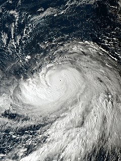
Typhoon Yutu, known in the Philippines as Typhoon Rosita, was an extremely powerful tropical cyclone that caused catastrophic destruction on the islands of Tinian and Saipan in the Northern Mariana Islands, and later impacted the Philippines. It is the strongest typhoon ever recorded to impact the Mariana Islands, and is tied as the second-strongest tropical cyclone to strike the United States and its unincorporated territories by both wind speed and barometric pressure. Yutu was also the most powerful tropical cyclone worldwide in 2018. The fortieth tropical depression, twenty-sixth named storm, twelfth typhoon, and the seventh super typhoon of the 2018 Pacific typhoon season, Yutu originated from a low-pressure area that formed in the western Pacific Ocean on October 15. The disturbance organized into a tropical depression on the same day, as ocean sea-surface heat content increased. Shortly after becoming a tropical depression, the Joint Typhoon Warning Center (JTWC) assigned the system the identifier 31W. The system continued to strengthen, becoming a tropical storm several hours later, with the Japan Meteorological Agency (JMA) naming the system Yutu. Increasingly favorable conditions allowed Yutu to explosively intensify, as the system maintained deep convection and subsequently became a severe tropical storm and then a typhoon.

Typhoon Faxai, known in Japan as Reiwa 1 Bōsō Peninsula Typhoon, was the first typhoon to strike the Kantō region since Mindulle in 2016, and the strongest typhoon to hit the region since Ma-on in 2004. It was also the worst to hit the region since Talas in 2011, until the region was hit by more destructive Typhoon Hagibis less than a month later. Forming as the fifteenth named storm of the 2019 Pacific typhoon season, the precursor to Faxai was first noted as a weak tropical depression to the east of the International Dateline on August 29. The depression then entered the West Pacific basin on August 30. After moving in a general westward direction, the system strengthened into a named tropical storm by September 5. Faxai then strengthened into the sixth typhoon of the season the next day. Two days later, Faxai reached its peak strength as a Category 4 typhoon just before making landfall in mainland Japan. Turning northeastward, Faxai rapidly weakened and became extratropical on September 10.
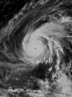
Typhoon Hagibis, known in Japan as Reiwa 1 East Japan Typhoon, was an extremely violent and large tropical cyclone that caused widespread destruction across its path. The thirty-eighth depression, ninth typhoon, and third super typhoon of the 2019 Pacific typhoon season, it was the strongest typhoon in decades to strike mainland Japan, and one of the largest typhoons ever recorded, with a peak gale-force diameter of 825 nautical miles. Hagibis was also the deadliest typhoon to strike Japan since Typhoon Tip in 1979. Its death toll is marginally higher than that of Typhoon Bess in 1982 and Typhoon Tokage in 2004.

Typhoon Kammuri, known in the Philippines as Typhoon Tisoy, was a powerful typhoon which impacted the Philippines in early December 2019. The twenty-eighth named storm and sixteenth typhoon of the 2019 Pacific typhoon season, Kammuri developed from a tropical wave situated a couple hundred miles south of the Mariana Islands. From November 25 up until November 27, the system tracked westward at a steady pace and rate of intensification, first making minor impacts in Guam. On November 28, the system intensified into a typhoon as environmental conditions became marginally conducive for significant development. From November 29 up until late December 1, Kammuri was unable to strengthen to previous estimates due to its near stationary movement as a result of weak steering currents, upwelling itself consequently. On December 2, the system tracked westward at a much faster speed of 12 mph (19 km/h) and rapidly intensified over warm Philippine Sea waters, before making landfall in the Bicol Region of the Philippines at peak intensity as a category 4-equivalent typhoon.

Typhoon Phanfone, known in the Philippines as Typhoon Ursula, was a relatively strong and deadly tropical cyclone which traversed through the Philippines on Christmas Eve and Christmas Day for the first time since Nock-ten in 2016.