Hangman Island, also known as Hayman's Island, is an island in the Quincy Bay area of the Boston Harbor Islands National Recreation Area. The island is a barren outcrop of bedrock, with a permanent size of half an acre rising to only three feet above sea level, plus an intertidal zone of a further 5 acres (20,000 m2). Access is by private boat only.

Green Island, also known as North Brewster Island, is a rocky outer island in the Boston Harbor Islands National Recreation Area, to the north of Calf Island and Hypocrite Channel. The island has a permanent size of 2.5 acres (10,000 m2), plus an intertidal zone of a further 15 acres (61,000 m2), and is exposed from the east and northeast with little soil or plant life. The island is named after Joseph Green, a well-known merchant, who owned the island during Colonial times.
Devils Back in Massachusetts, USA, is a very small and barren rock in Massachusetts Bay located within the city limits of Boston. The rock is northeast of Aldridge Ledge, southwest of Commissioners Ledge, northwest of Half Tide Rocks, west of Green Island, and just east of the South Channel.
The Hypocrite Channel is a small channel in Massachusetts Bay, located within the city limits of Boston. It's also located within the Boston Harbor Islands National Recreation Area. The channel runs between the islands of Half Tide Rocks, Calf Island, Little Calf Island, and Green Island.
The Salem Channel is a channel in the Salem Sound that stretches from Winter Island in the city of Salem to Misery Shoal in the city limits of Beverly.
Shag Rocks are barren rocks situated 8 nautical miles offshore of Custom House Tower in downtown Boston, in the Boston Harbor Islands National Recreation Area and within the city limits of Boston. The rocks are northeast of Little Brewster Island and east of Great Brewster Island and have been the site of several shipwrecks. Boston Light on Little Brewster Island warns mariners to steer clear of the rocks. Public access is impractical.
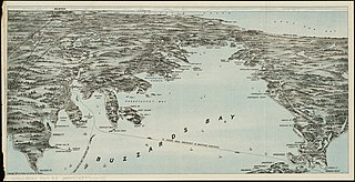
Angelica Rock, also known as Angelica Island, is a one-acre (0.4 ha) rock island emerging from Buzzards Bay, within the town limits of Fairhaven, Massachusetts. The rock is privately owned and is located southwest of Sconticut Neck and Wilbur's Point. The island is home to a number of sea birds as well as a collapsed windmill.
Orealla is an Indigenous community in the East Berbice-Corentyne Region of Guyana, on the Courantyne River, approximately 33 miles (53 km) south of Crabwood Creek and 11 miles (18 km) north of Epira, located at 5°17′50″N57°20′50″W, altitude 11 metres. 15 miles (24 km) south-east on the other side of the Courantyne River lies the Surinamese village of Apoera. Orealla is an indigenous village.
Calf Island, also known as Apthorps Island, is an island situated some 9 miles (14 km) offshore of downtown Boston in Boston Harbor Islands National and State Park. The island has a permanent size of 18 acres (73,000 m2), plus an intertidal zone of a further 16 acres (65,000 m2).
Little Calf Island is a small rocky island in the Boston Harbor Islands National Recreation Area, some 9 miles (14 km) offshore from downtown Boston, Massachusetts. The island has no vegetation and no history of human occupation. It is used for nesting by gulls and cormorants which can be aggressive during their nesting season. Access by humans is by private boat only, and is discouraged.

Snake Island, also known as Bare Island, is an island in Boston Harbor. The island is part of the Boston Harbor Islands National Recreation Area and is situated in the inner harbor between the town of Winthrop and the reclaimed land that forms Logan International Airport. It is part of the Town of Winthrop. It is named for its serpentine shape, and has a permanent size of 3 acres (12,000 m2), and rises to a height of 10 feet (3.0 m) above sea level.

Spinnaker Island is an island in the Hingham Bay area of Boston Harbor in Massachusetts, USA. The island is part of the town of Hull, to which it is connected by a bridge, and is one of the few harbor islands that neither forms part of the Boston Harbor Islands National Recreation Area nor is considered within the municipal limits of the city of Boston.

Humarock is part of Scituate, Massachusetts, United States. Humarock is a picturesque seaside village surrounded by water and situated on Cape Cod Bay midway between Boston and Plymouth. It was separated from the rest of the town in the Portland Gale of 1898 in which the mouth of the North River shifted. Humarock is now accessible from Scituate only by boat or from the Town of Marshfield by bridge.

The Norwalk Islands are a chain of more than 25 islands amid partly submerged boulders, reefs and mudflats along a six-mile (10 km) stretch and mostly about a mile off the coast of Norwalk, Connecticut, and southwest Westport, Connecticut, in Long Island Sound.
Tioga is an unincorporated community in Walker Township, Hancock County, Illinois, United States.

Cormorant Rock is a small island about 300 feet (91 m) off the southeastern tip of Children's Island just outside Marblehead Harbor, at latitude 42.510ºN, longitude 70.812ºW. Formerly known as Cat Island Rock and Eastern Rock of Cat Island, it is considered to be a part of Children's Island and was the location of a navigational spar erected in 1808 by the Marblehead Marine Society. Both islands are part of the city of Salem, even though they are closer to mainland Marblehead and are enclaved by its (water) territory.
Sandspur Island is the largest spoil island in Biscayne Bay, which is part of the Oleta River State Park in Southern Florida. The island is 15 acres (6.1 ha), the largest island in North Bay of the Biscayne Bay and only accessible by boat.