
The South Street Seaport is a historic area in the New York City borough of Manhattan, centered where Fulton Street meets the East River, within the Financial District of Lower Manhattan. The Seaport is a designated historic district. It is part of Manhattan Community Board 1 in Lower Manhattan, and is next to the East River to the southeast and the Two Bridges neighborhood to the northeast.

Province House in Halifax is where the Nova Scotia legislative assembly, known officially as the Nova Scotia House of Assembly, has met every year since 1819, making it the longest serving legislative building in Canada. The building is Canada's oldest house of government. Standing three storeys tall, the structure is considered one of the finest examples of Palladian architecture in North America.
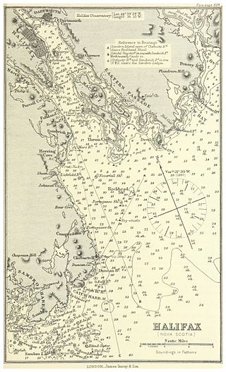
Halifax Harbour is a large natural harbour on the Atlantic coast of Nova Scotia, Canada, located in the Halifax Regional Municipality. Halifax largely owes its existence to the harbour, being one of the largest and deepest ice-free natural harbours in the world. Before Confederation it was one of the most important commercial ports on the Atlantic seaboard. In 1917, it was the site of the world's largest man-made accidental explosion, when the SS Mont-Blanc blew up in the Halifax Explosion on December 6.

The Westin Nova Scotian is a Canadian hotel located in Halifax, Nova Scotia, owned and operated by New Castle Hotels and Resorts. It was built in 1928 by the Canadian National Railway as the Nova Scotian Hotel and after several changes of owners and names in the late 20th century became the Westin Nova Scotian in 1996.

The Shubenacadie River is a river in Nova Scotia, Canada. It has a meander length of approximately 72 km from its source at Shubenacadie Grand Lake to its mouth at the historic seaport village of Maitland on Cobequid Bay, site of the building of the William D. Lawrence, the largest wooden ship ever built in Canada. In 2009, the I Backpack Canada blog named the Shubenacadie one of the top five whitewater rivers in Canada. The lower 30 km of the river is tidal and the river experiences a tidal bore twice daily, with some bores reaching up to 3 m in height at certain points along the river. Local tourism operators offer adventure seekers a chance to ride with the bore on high-horse power Zodiac Hurricanes. Tidal Bore Rafting was invented at the Tidal Bore Rafting Resort by H. Knoll. It is also a popular surfing spot for experienced sea kayakers.
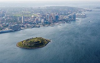
Georges Island is a glacial drumlin and the largest island entirely within the harbour limits of Halifax Harbour located in Nova Scotia's Halifax Regional Municipality. The Island is the location of Fort Charlotte - named after King George's wife Charlotte. Fort Charlotte was built during Father Le Loutre's War, a year after Citadel Hill. The island is now a National Historic Site of Canada. As of August 6, 2020, the island is open to the public on the weekends, from June until Thanksgiving weekend.

McNabs Island is the largest island in Halifax Harbour located in Halifax Regional Municipality, Nova Scotia, Canada. It played a major role in defending Halifax Harbour and is now a provincial park. The island was settled by Britons in the 1750s and later by Peter McNab, and McNab family members lived on the island until 1934.

The Halifax Court House is a historic building in downtown Halifax, Nova Scotia. Its main section was completed in 1863, with the east wing, built in 1930, being the newest portion. The Italian Renaissance style building was designed by William Thomas, a Toronto architect who created prominent structures across Canada, and built by George Lang.

The Halifax Armoury is a military structure in central Halifax, Nova Scotia, Canada. The armoury is the home base of The Princess Louise Fusiliers, and several cadet units.
Purcell's Cove or Purcells Cove is a community within the Halifax Regional Municipality, Nova Scotia, Canada, on the west side of Halifax Harbour from the Northwest Arm to Fergusons Cove along Route 253.

Beaver Bank is a suburban community northeast of Lower Sackville on the Beaver Bank Road in Nova Scotia, Canada, within the Halifax Regional Municipality. It is about 35 kilometres from the City of Halifax.

The West End is a neighbourhood of Halifax Regional Municipality in the Canadian province of Nova Scotia, located on the western half of the Halifax Peninsula. The West End is predominantly middle class with many blocks of tree-lined older residential streets. However, it is also home to many students and small low rent units. Rising real estate prices have also led to some levels of gentrification.

The Halifax Waterfront Boardwalk is a public footpath located on the Halifax Harbour waterfront in Halifax, Nova Scotia, Canada.

The RBC Waterside Centre is a commercial development in the downtown core of Halifax, Nova Scotia, Canada built by local real estate developer Armour Group. The project involves demolishing six heritage buildings and replacing them with a nine storey retail and office building, clad at ground level with the reconstructed facades of most of the former heritage buildings.

The Halifax Seaport is a Canadian commercial development located on the Halifax, Nova Scotia waterfront, at the southern end of the Halifax Boardwalk. It is a re-use of former shipping warehouses. The intent of the multi-year project is to create a thriving new arts and culture district in the city.
The Dartmouth Marine Slips was an historic shipyard and marine railway which operated in Dartmouth, Nova Scotia between 1859 and 2003. It was noted for important wartime work during the American Civil War as well as during the Battle of the Atlantic in World War II. After its closure, the site began redevelopment as King's Wharf, a high-rise residential development.

The Prince of Wales Tower is the oldest martello tower in North America and is located in Point Pleasant Park, Halifax Regional Municipality, Nova Scotia, Canada. It was built in 1796 by Captain James Straton and was used as a redoubt and a powder magazine. Restored, it was designated a National Historic Site of Canada in 1943.

Scott Manor House was built sometime between 1769 and 1772 and is now a museum in Bedford, Nova Scotia. It is the second oldest house in the Halifax Regional Municipality, after the Morris House, and was built by Joseph Scott on the land once owned by his brother Captain George Scott. The house was built next to Fort Sackville, which was under the command of Joseph Scott (1760).

Cambridge Military Library is a library building in Royal Artillery Park in Halifax, Nova Scotia, Canada which was built in 1886. The building was created to house the garrison library collection, which had been moved from various locations in the city since its creation in 1817. It is the oldest non-university public library collection in Canada. This building was the social and literary centre of military Halifax. In 1902, the officers of the garrison requested the library be named after the Prince George, Duke of Cambridge.

The Black-Binney House was a former residence built in 1819 in Halifax, Nova Scotia which is now a National Historic Site of Canada. The house was built by John Black (merchant) and is reflective of the Palladian-inspired residences common during the late 18th and early 19th centuries in Eastern Canada. In 1857, Hibbert Binney subdivided the property to build the St. Matthew's United Church (Halifax). In 1965 Sidney Culverwell Oland purchased and renovated the building to house the Nova Scotia Division of the Canadian Corps of Commissionaires.