Mount Pleasant is a large suburban town in Charleston County, South Carolina, United States. In the Lowcountry, it is the fourth-most populous municipality in South Carolina, and for several years was one of the state's fastest-growing areas, doubling in population between 1990 and 2000. The population was 90,801 at the 2020 census. It is part of the Charleston metropolitan area.

The Battery is a landmark defensive seawall and promenade in Charleston, South Carolina. Named for a pre–Civil War coastal defense artillery battery originally built by the British at the site, it stretches along the lower shores of the Charleston peninsula, bordered by the Ashley and Cooper Rivers, which meet here to form Charleston Harbor.
I'On is a mixed-use New Urbanist Traditional Neighborhood Development (TND) style community located in Mount Pleasant, South Carolina, United States just northeast of Charleston. I'On was one of the earliest full-time residential New Urbanist communities developed in the US.

West Ashley, or more formally, west of the Ashley, is one of the six distinct areas of the city proper of Charleston, South Carolina. As of July 2022, its estimated population was 83,996. Its name is derived from the fact that the land is west of the Ashley River.
Rainbow Row is the name for a series of thirteen colorful historic houses in Charleston, South Carolina. The houses are located north of Tradd St. and south of Elliott St. on East Bay Street, that is, 79 to 107 East Bay Street. The name Rainbow Row was coined after the pastel colors they were painted as they were restored in the 1930s and 1940s. It is a popular tourist attraction and is one of the most photographed parts of Charleston.

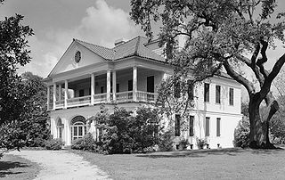
Presqu'ile, or Presqui'ile,, the French term for "peninsula", was an appropriate name for the house built in Hampstead Village at 2 Amherst St., Charleston, South Carolina between 1802 and 1808 because, at the time, the house stood on a finger of high ground that projected into the marshes of the Cooper River. The builder, Jacob Belser, was a planter, attorney, and state senator (1812–15).
Riverland Terrace is a historic neighborhood in Charleston, South Carolina. It was first developed starting in 1925. It is one of James Island, South Carolina's oldest neighborhoods. The Terrace is located 10 minutes west of downtown Charleston along Wappoo Creek and the inland waterway. The neighborhood boasts a public boat landing, Charleston Municipal Golf Course, a playground, five restaurants and numerous antique shops.
Lowndes Grove, also known as The Grove or Grove Farm, is a waterfront estate built in about 1786 on the Ashley River in Charleston. It is located in the Wagener Terrace neighborhood on a triangular plot of land bordered by St. Margaret Street, 5th Avenue, and 6th Avenue. It was named to the National Register of Historic Places on August 30, 1978.

Historic Charleston Foundation (HCF) was founded in 1947 to preserve and protect the integrity of the architectural, historical, and cultural heritage of Charleston, South Carolina, United States. The Foundation undertakes advocacy, participation in community planning, educational and volunteer programs, the preservation of historic places, research, and technical and financial assistance programs for the preservation of historic properties. Winslow Hastie has been the President & CEO of Historic Charleston Foundation since 2018.
Craven County, South Carolina was one of the three original counties established by the Lords Proprietor of the English colony of Carolana in 1682 to include the colony's lands stretching from Awendaw Creek north to the western shore of Winyah Bay and inland. In 1685, the original county of Berkeley was expanded to include the southwestern part of Craven County, and in 1691, land was added to Craven County from the previously unorganized land to its northeast.

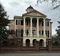
The Patrick O'Donnell House is the largest example of Italianate architecture in Charleston, South Carolina. It was built for Patrick O'Donnell (1806-1882), perhaps in 1856 or 1857. Other research has suggested a construction date of 1865. Local lore has it that the three-and-a-half-story house was built for his would-be bride who later refused to marry him, giving rise to the house's popular name, "O'Donnell's Folly." Between 1907 and 1937, it was home to Josephine Pinckney; both the Charleston Poetry Society and the Society for the Preservation of Spirituals were formed at the house during her ownership.

The Richard Brenan House is an early 19th-century house at 207 Calhoun St., Charleston, South Carolina. The house was built for Richard Brenan, a merchant, in 1817 and originally included the adjacent land to the west. The house is a three-story Charleston single house with quoins and fine cornice. The house was a two-story piazza on the west side.
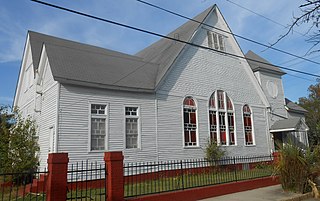
The Emma Abbott Memorial Chapel is a late Victorian church located at 52 Cooper St., Charleston, South Carolina. On October 4, 1890, the Citadel Square Baptist Church bought a parcel at the northwest corner of Cooper and America Streets for the construction of a mission church serving the Eastside. The land was marshy and had to be filled at a cost of $1500. In January 1891, Citadel Square Church learned that it had been named as one of several beneficiaries of the estate of Emma Abbott, a popular opera singer. She had attended church at Citadel Square Church during trips to Charleston in 1880, 1886, and February 1888.
Charles A. Brown High School was a high school open from 1962 to 1982 in the predominantly African-American community on the east side of Charleston, South Carolina, United States. The school was built because of the growing population in the downtown community It was located at 25 Blake Street and became part of a 1960s project to provide higher quality education to African American students.

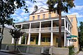
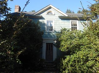
The St. Johannes Rectory is a historic two-story home in the Ansonborough neighborhood of Charleston, South Carolina. The house was built about 1846 by Joel Smith, a planter from Abbeville, South Carolina. The house follows a side-hall plan with two large rooms on the first floor, both of which open onto the piazzas on the west, and a main staircase and hallway along the east side.

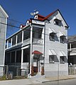
The Augustus Taft House is a Greek Revival house at 57 Laurens St., Charleston, South Carolina in the historic Ansonborough neighborhood.
Wraggborough is a neighborhood in downtown Charleston, South Carolina, named after slave trader Joseph Wragg, and noted for its association with the slave trade. Wraggborough is part of Mazyck-Wraggborough, also referred to as Wraggborough for short. The neighborhood is located between Ansonborough to the south and Hampstead Village to the north.
Wagener Terrace in Charleston, South Carolina is a large neighborhood made property that had been owned by Louis Dunnemann and Capt. F.W. Wagener.

Meeting Street Manor is a housing complex located in the upper Eastside in Charleston, South Carolina, and was the city's first housing development. When built in the 1930s, the development was technically two racially segregated halves with separate names. Since desegregation, both components are typically referred to as Meeting Street Manor, originally the name for the Whites-only portion.
Hampstead Mall is a public park in Charleston, South Carolina, of 140,625 square feet in the Hampstead Village neighborhood at the intersection of Columbus and America Streets.