Four buildings in Boston, Massachusetts, have been known as the "John Hancock Building". All were built by the John Hancock Insurance companies. References to the John Hancock building usually refer to the 60-story, sleek glass building on Clarendon Street also known as the John Hancock Tower or Hancock Place.
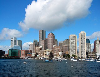
The Financial District of Boston is located in Downtown Boston, near Government Center and Chinatown.
The Boston City Hospital (1864–1996), in Boston, Massachusetts, was a public hospital, located in the South End. It was "intended for the use and comfort of poor patients, to whom medical care will be provided at the expense of the city, and ... to provide accommodations and medical treatment to others, who do not wish to be regarded as dependent on public charity." In 1996, it merged with the Boston University Medical Center Hospital to form the Boston Medical Center.

Long Wharf is a historic American pier in Boston, Massachusetts, built between 1710 and 1721. It once extended from State Street nearly a half-mile into Boston Harbor; today, the much-shortened wharf functions as a dock for passenger ferries and sightseeing boats.

The current incarnation of Rowes Wharf is a modern development in downtown Boston, Massachusetts. It is best known for the Boston Harbor Hotel's multi-story arch over the wide public plaza between Atlantic Avenue and the Boston Harbor waterfront. Along the waterfront can be found a marina, restaurants, a water transportation terminal, and a floating stage offering free concerts and movies during the summer.
North Quincy is a neighborhood of Quincy, Massachusetts. It is separated from the city of Boston by the Neponset River, and borders the Quincy neighborhoods of Squantum, Montclair and Wollaston. It contains the smaller neighborhoods of Atlantic and Norfolk Downs, as well as much of Wollaston Beach.
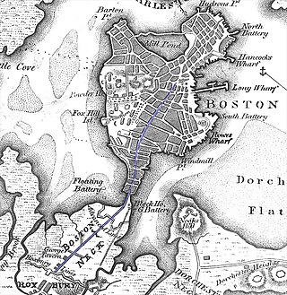
The Boston Neck or Roxbury Neck was an isthmus, a narrow strip of land connecting the then-peninsular city of Boston to the mainland city of Roxbury. The surrounding area was gradually filled in as the city of Boston expanded in population. The land formerly composing the neck is part of the neighborhood now known as the South End.
Park Street is a short but historic road in the center of Boston, Massachusetts. It begins at the top of Beacon Hill, at the intersection of Beacon Street, where it is lined up with the front of the Massachusetts State House. It then spills down the hill toward Tremont Street, with Boston Common to its west.

Fort Point is a neighborhood or district of Boston, Massachusetts, and where a fort stood which guarded the city in colonial times.
Quincy Center is an area of Quincy, Massachusetts, centered along Hancock Street and covering the downtown area of the city. The area is a retail shopping locale and also includes the City Hall, the Thomas Crane Public Library, several churches, including the United First Parish Church, where John Adams and John Quincy Adams were buried, and numerous office buildings, including the headquarters of Stop & Shop. A memorial to the soldiers of World War I along with various statues of other great figures can be found in the vicinity. It is served by a large Massachusetts Bay Transportation Authority (MBTA) station which includes subway access and bus services.

Children's Wharf is a wharf on Congress Street in Boston, Massachusetts, on the Fort Point Channel with views of the Financial District and Boston Harbor. The wharf has sitting areas, patches of lawn, and several tourist attractions.

Milk Street is a street in the financial district of Boston, Massachusetts, which was one of Boston's earliest highways. The name "Milk Street" was most likely given to the street in 1708 due to a milk market at the location, although Grace Croft's 1952 work "History and Genealogy of Milk Family" instead proposes that Milk Street may have been named for John Milk, an early shipwright in Boston. The land was originally conveyed to his father, also John Milk, in October 1666.

State Street is one of the oldest and most historic streets in Boston, Massachusetts, United States. Located in the financial district, it is the site of some historic landmarks, such as Long Wharf, the Old State House and the Boston Custom House.

The Brattle Street Church (1698–1876) was a Congregational and Unitarian church on Brattle Street in Boston, Massachusetts.

India Wharf in Boston, Massachusetts, flourished in the 19th century, when it was one of the largest commercial wharves in the port. The structure began in 1804 to accommodate international trade at a time when several other improvements to the Boston waterfront occurred, such as the creation of Broad Street and India Street.
The Lexington Historical Society, founded in 1886 in Lexington, Massachusetts, preserves and celebrates Lexington's history, with a special emphasis on the town's important role in the beginning of the American Revolution. The Society presents entertaining and educational programs year-round in the restored Lexington Depot. The Depot is available for rental by Lexington community groups, residents and businesses.

Congress Street in Boston, Massachusetts, is located in the Financial District and South Boston. It was first named in 1800. It was extended in 1854 as far as Atlantic Avenue, and in 1874 across Fort Point Channel into South Boston. Today's Congress Street consists of several segments of streets, previously named Atkinson's Street, Dalton Street, Gray's Alley, Leverett's Lane, Quaker Lane, and Shrimpton's Lane.
Hartwick is a census-designated place (CDP) forming the central settlement of the town of Hartwick in Otsego County, New York, United States. It is located at the corner of CR-11 and NY-205. The population of the CDP was 629 at the 2010 census.
Lewis Wharf is a showpiece of waterfront urban renewal in Boston's historic North End. The granite structures on the wharf were built as an early 19th-century shopping mall in the era before railroads when water transport was the most efficient way to move commodities to marketplaces.

A Once and Future Shoreline is a permanent public artwork that graphically marks the edge of Boston Harbor, circa 1630, into the granite paving blocks of the plaza on the West side of the historic Faneuil Hall building. The 850-foot-long artwork depicts the location of a pre-colonial shoreline by graphically etching silhouettes of materials that are found typically along the high tide line. The artwork offers a way to engage the imagination in an exploration of the changes to this now urban site from a salty tidal marsh, to an active pedestrian plaza.
