
Cartography is the study and practice of making and using maps. Combining science, aesthetics and technique, cartography builds on the premise that reality can be modeled in ways that communicate spatial information effectively.
An atlas is a collection of maps; it is typically a bundle of maps of Earth or of a region of Earth.

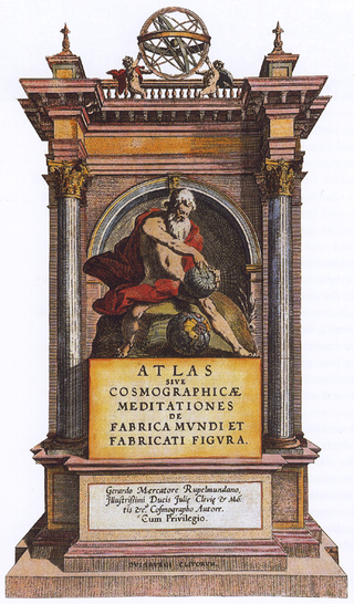
Gerardus Mercator was a Flemish geographer, cosmographer and cartographer. He is most renowned for creating the 1569 world map based on a new projection which represented sailing courses of constant bearing as straight lines—an innovation that is still employed in nautical charts.
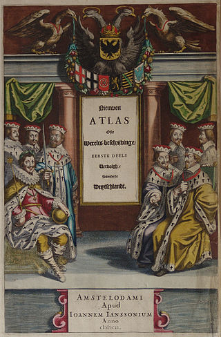
Johannes Janssonius was a Dutch cartographer and publisher who lived and worked in Amsterdam in the 17th century.

Petrus Plancius was a Dutch-Flemish astronomer, cartographer and clergyman. He was born as Pieter Platevoet in Dranouter, now in Heuvelland, West Flanders. He studied theology in Germany and England. At the age of 24 he became a minister in the Dutch Reformed Church.

Willem Janszoon Blaeu, also abbreviated to Willem Jansz. Blaeu, was a Dutch cartographer, atlas maker, and publisher. Along with his son Johannes Blaeu, Willem is considered one of the notable figures of the Netherlandish or Dutch school of cartography during its golden age in the 16th and 17th centuries.

Jodocus Hondius was a Flemish and Dutch engraver and cartographer. He is sometimes called Jodocus Hondius the Elder to distinguish him from his son Jodocus Hondius II. Hondius is best known for his early maps of the New World and Europe, for re-establishing the reputation of the work of Gerard Mercator, and for his portraits of Francis Drake. He inherited and republished the plates of Mercator, thus reviving his legacy, also making sure to include independent revisions to his work. One of the notable figures in the Golden Age of Dutch cartography, he helped establish Amsterdam as the center of cartography in Europe in the 17th century.

Uranometria is a star atlas produced by Johann Bayer. It was published in Augsburg in 1603 by Christoph Mang under the full title Uranometria: omnium asterismorum continens schemata, nova methodo delineata, aereis laminis expressa. This translates to "Uranometria, containing charts of all the constellations, drawn by a new method and engraved on copper plates". The word "Uranometria" derives from Urania, muse of the heavens and "uranos" (oυρανός) the Greek word for sky / heavens. A literal translation of "Uranometria" is "Measuring the Heavens".

Julius Schiller was a lawyer from Augsburg, who like his fellow citizen and colleague Johann Bayer published a star atlas in celestial cartography.

Joan Blaeu was a Dutch cartographer born in Alkmaar, the son of cartographer Willem Blaeu.
The history of cartography refers to the development and consequences of cartography, or mapmaking technology, throughout human history. Maps have been one of the most important human inventions for millennia, allowing humans to explain and navigate their way through the world.
Celestial cartography, uranography, astrography or star cartography is the aspect of astronomy and branch of cartography concerned with mapping stars, galaxies, and other astronomical objects on the celestial sphere. Measuring the position and light of charted objects requires a variety of instruments and techniques. These techniques have developed from angle measurements with quadrants and the unaided eye, through sextants combined with lenses for light magnification, up to current methods which include computer-automated space telescopes. Uranographers have historically produced planetary position tables, star tables, and star maps for use by both amateur and professional astronomers. More recently, computerized star maps have been compiled, and automated positioning of telescopes uses databases of stars and of other astronomical objects.
Henricus Hondius II was a Dutch engraver, cartographer, and publisher.

Pieter Goos (1616–1675) was a Dutch cartographer, copperplate engraver, publisher and bookseller. He was the son of Abraham Goos (1590–1643), also a cartographer and map seller. From 1666, Pieter Goos published a number of well produced atlases. He was the first to map Christmas Island, which he labelled "Mony" in his map of the East Indies, published in his 1666 Zee-Atlas. His Atlas ofte Water-Weereld has been cited as one of the best maritime atlases of its time. Another of his fine works was the Oost Indien map published in 1680.

Abraham Goos was a Dutch cartographer, publisher, and engraver. He made globes, maps of North America, a comprehensive map of European coastlines, and the first printed Hebrew language map of The Holy Land.
Imago universi in Latin means "image of the universe".

Gaspard van der Heyden was a goldsmith, engraver, master printer and builder of precision astronomical instruments including terrestrial and celestial globes from Leuven, Belgium. He was well known among the humanists in Leuven as well as among scientists and mathematicians.

Arnold or Arnoldus Mercator was a Southern Netherlandish cartographer, mathematician and classical philologist. He was the eldest son of cartographer Gerardus Mercator and a brother of Rumold Mercator.
Colette van den Keere (1568–1629) was a Dutch engraver who was the sister of engraver Pieter van den Keere. She married his master, the cartographer Jodocus Hondius in 1587 and she ran the family business for several years. She is credited with engraving a posthumous portrait of her husband.
