
Portage County is a county in the U.S. state of Ohio. As of the 2020 census, the population was 161,791. Located in Northeast Ohio, Portage County is part of the Akron Metropolitan Statistical Area, which is also included in the Cleveland–Akron–Canton Combined Statistical Area. Its county seat is Ravenna and its largest city is Kent. The county, named for the portage between the Cuyahoga and Tuscarawas rivers, was created in 1807 and formally organized in 1808. In addition to the cities of Kent and Ravenna, Portage County also includes the cities of Aurora and Streetsboro, along with five villages, 18 civil townships, and several unincorporated places within those townships. Additionally, the county includes parts of the city of Tallmadge, and part of the village of Mogadore, both of which are mostly in neighboring Summit County.

Cook County is the easternmost county in the U.S. state of Minnesota. As of the 2020 census, the population was 5,600, making it Minnesota's seventh-least populous county. Its county seat is Grand Marais. The Grand Portage Indian Reservation is in the county.

Aitkin County is a county in the U.S. state of Minnesota. As of the 2020 census, the population was 15,697. Its county seat is Aitkin. Part of the Mille Lacs Indian Reservation is in the county. The county was created in 1857 and organized in 1871.

Keweenaw County is a county in the western Upper Peninsula of the U.S. state of Michigan. As of the 2020 census, the county's population was 2,046, making it Michigan's least populous county. It is also the state's largest county by total area, including the waters of Lake Superior, as well as the state's northernmost county. The county seat is Eagle River.
Ponto Lake Township is a township in Cass County, Minnesota, United States. The population was 530 as of the 2000 census. The etymology of the name Ponto is obscure.
Powers Township is a township in Cass County, Minnesota, United States. The population was 918 at the 2000 census. Powers Township was named for Gorham Powers, a Minnesota politician who owned land there.
Halden Township is a township in Saint Louis County, Minnesota, United States. The population was 129 at the 2010 census.
Portage Township is a township in Saint Louis County, Minnesota, United States. The population was 170 at the 2010 census.

Portage Township is a township in Cambria County, Pennsylvania, United States. It surrounds the borough of Portage. The township population was 3,640 at the 2010 census. It is part of the Johnstown, Pennsylvania Metropolitan Statistical Area.
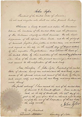
The Webster–Ashburton Treaty, signed August 9, 1842, was a treaty that resolved several border issues between the United States and the British North American colonies. Signed under John Tyler's presidency, it resolved the so-called Aroostook War. The provisions of the treaty included:

The Northwest Angle, known simply as the Angle by locals, and coextensive with Angle Township, is a pene-exclave of northern Lake of the Woods County, Minnesota. Except for surveying errors, it is the only place in the contiguous United States north of the 49th parallel, which forms the border between the U.S. and Canada from the Northwest Angle westward to the Strait of Georgia. The land area of the Angle is separated from the rest of Minnesota by Lake of the Woods, but shares a land border with Canada. It is one of six non-island locations in the 48 contiguous states that are practical exclaves of the U.S. It is the northernmost township in Minnesota and contains the northernmost point in the contiguous 48 states. The unincorporated community of Angle Inlet is in the Northwest Angle.

The Pigeon River forms part of the Canada–United States border between the state of Minnesota and the province of Ontario, west of Lake Superior. In pre-industrial times, the river was a waterway of great importance for transportation and the fur trade.
Portage Township may refer to:

Grand Portage National Monument is a United States National Monument located on the north shore of Lake Superior in northeastern Minnesota that preserves a vital center of fur trade activity and Anishinaabeg Ojibwe heritage. The area became one of the British Empire's four main fur trading centers in North America, along with Fort Niagara, Fort Detroit, and Michilimackinac.

Grand Portage State Park is a state park at the northeastern tip of the U.S. state of Minnesota, on the Canada–United States border. It contains a 120-foot (37 m) waterfall, the tallest in the state, on the Pigeon River. The High Falls and other waterfalls and rapids upstream necessitated a historically important portage on a fur trade route between the Great Lakes and inland Canada. This 8.5-mile (13.7 km) path as well as the sites of historic forts at either end are preserved in nearby Grand Portage National Monument.

Minnesota State Highway 232 (MN 232) was a 9.540-mile-long (15.353 km) highway in northeast Minnesota, which ran from its intersection with Aitkin County Road 3 on the east edge of Palisade and continued east to its eastern terminus at its intersection with State Highway 65 and Aitkin County Road 14 in Shamrock Township, near Big Sandy Lake and the town of McGregor. Almost sixteen years after the Minnesota Legislature repealed MN 232's route definition in 1996, MnDOT and Aitkin County finally came to an agreement in April 2012 to transfer the road to the county, which became an extension of Aitkin County Road 3.
Portage River may refer to:
Height of Land Portage is a portage along the historic Boundary Waters route between Canada and the United States. Located at the border of the Canadian province of Ontario and the U.S. state of Minnesota, the path is a relatively easy crossing of the Laurentian Divide separating the Hudson Bay and Great Lakes-St. Lawrence watersheds.

This article covers the water based Canadian canoe routes used by early explorers of Canada with special emphasis on the fur trade.

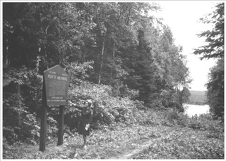
Height of Land Portage is a historic portage route between the Embarrass River and the Pike River in St. Louis County, Minnesota, United States. The 4.6-mile (7.4 km) route crosses the Laurentian Divide, providing access between the Hudson Bay drainage basin and the Great Lakes Basin. The portage was a key connection for canoe-based travelers from the 1630s to the 1870s. It was listed on the National Register of Historic Places in 1992 for its state-level significance in the themes of archaeology, exploration/settlement, and transportation. It was nominated for its potential archaeological resources and associations with the fur trade and European expansion in North America.