Related Research Articles

Caversham is a village and suburb of Reading in Berkshire, England, located directly north of Reading town centre across the River Thames. Caversham rises from the River Thames, lying on flood plain and the lowest reaches of the Chiltern Hills. Two road bridges, including Caversham Bridge, and two footbridges join Caversham to the rest of Reading. Named areas within the village include Emmer Green, Lower Caversham, Caversham Heights and Caversham Park Village. Notable landmarks include Caversham Court, a public park and former country house; Caversham Lakes; and part of the Thames Path national trail.

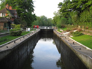
Caversham Lock is a lock and main weir on the River Thames in England at Reading, Berkshire. Both the lock and main weir are connected to De Bohun Island. The Thames Navigation Commissioners built the original lock in 1778. Additional sluices north of View Island and Heron Island form the whole weir complex. A footbridge, known as The Clappers, passes over the weir and all three islands to connect Lower Caversham to Reading.
Sonning Lock is a lock and associated weir situated on the River Thames at the village of Sonning near Reading, Berkshire, England. The first lock was built by the Thames Navigation Commission in 1773 and it has been rebuilt three times since then. There is a weir a little upstream at the top of the island where Sonning Backwater separates from the main course of the river.
Fry's Island, also known as De Montfort Island, is an island in the River Thames in England. The island is on the reach above Caversham Lock at Reading, Berkshire. The centre of Reading is to the south and the suburb of Caversham to the immediate north.

Pipers Island, or Piper's Island, is the third-smallest map-named island in the River Thames, in England. It is on the Reading, Berkshire reach. It is toward the edge of the central urban area of the town of Reading and connected by a gangway to Caversham Bridge, a road and pedestrian bridge that links that town to its left bank suburb of Caversham.

Lower Caversham is an area of the village of Caversham in Berkshire, England. It forms part of Reading. Lower Caversham has no formal boundaries, but the name usually refers to that part of Caversham situated on lower ground to the east of central Caversham, close to the River Thames. Lower Caversham, as well as the remainder of Reading north of the Thames lies in the historic county of Oxfordshire.

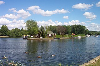
Caversham Lakes is a set of lakes created through gravel extraction between the suburb of Caversham in Reading, Berkshire and the hamlet of Sonning Eye in Oxfordshire, just north of the River Thames and also refers to the sports buildings and facilities alongside those lakes.

The Thames and Kennet Marina is located at Caversham Lakes in south Oxfordshire, England, just north off the River Thames on the reach above Sonning Lock. It is just to the east of Caversham, a suburb in the north of Reading, Berkshire. The marina is named after the River Thames and the River Kennet which joins the Thames nearby.

St Mary's Island is a tiny island in the River Thames in England. It has a size of about 150 m by 50 m.

View Island is a small island near Caversham Lock, on the River Thames at Reading, Berkshire in England.

Hollyhock Island is an inhabited island in the River Thames in England located between Bell Weir Lock and Penton Hook Lock.

Corporation Island is a small island on the River Thames in London. The island is between Richmond Bridge and Richmond Railway Bridge, where it forms part of the celebrated view from the Richmond waterfront. Its name seems to derive from its owners, the Corporation of Richmond, now the London Borough of Richmond upon Thames. It is uninhabited and heavily wooded, and was formerly known as Richmond Ait.
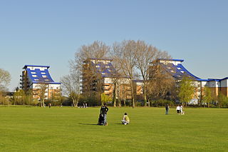
King's Meadow is a park in Reading, Berkshire, England, located next to the River Thames. It stretches from the Coal Woodland to King's Meadow Road near Reading Bridge. The Thames Path long distance footpath runs through the length of King's Meadow, which is visible from the railway when entering or leaving Reading railway station from the eastern side.

Appletree Eyot is an island in the River Thames in Oxfordshire, England.
Reading Rowing Club is a rowing club, on the River Thames in England, on the Berkshire bank at Reading close to the town centre just above Caversham Bridge, the westerly bridge in the town on the reach above Caversham Lock.

Poplar Island is an island in the River Thames in Oxfordshire, England.

Benn's Island, previously named Church Eyot, Kember's Eyot and sometimes referred to as Benn's Ait, is a private 0.1-acre (0.040 ha) ait (island) on the River Thames south-west of London. It is among a string of narrow islands above Molesey Lock and due to its clubhouse and size — the second-smallest named island on the Thames — it has deep foundation pilings to raise the building more than 1 m above the water line.

Sheepwash Channel connects the River Thames to the west and the Castle Mill Stream next to the Oxford Canal to the east, in west Oxford, England. To the north are Cripley Meadow and Fiddler's Island. To the south are Osney Island and the Botley Road.

The following is a timeline of the history of Reading, the county town of Berkshire in England.

Christchurch Meadows is a park in Reading, Berkshire, England, located next to the River Thames. It stretches along the north (Caversham) side of the river, between Caversham Bridge and Reading Bridge, and is linked to the south (Reading) bank by the Christchurch Bridge, a pedestrian and cycle bridge built in 2015. The name of the meadow derives from Christ Church in Oxford, whose dean owned 25 acres (10 ha) of farmland in Reading.
References
- ↑ Lever, Edward (3 February 2011). "Heron Island, Caversham". Pictures of Caversham. Retrieved 30 March 2011.
- ↑ "Heron Island Caversham Reading RG4". www.houseprices.co.uk. Retrieved 30 March 2011.
- ↑ Local Photos — View Island Archived 24 July 2011 at the Wayback Machine , Caversham.org.uk.
51°27′46″N0°57′42″W / 51.4627°N 0.9616°W
| | This Berkshire location article is a stub. You can help Wikipedia by expanding it. |