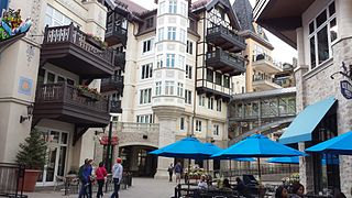
Vail is a Home Rule Municipality in Eagle County, Colorado, United States. The population of the town was 5,305 in 2010. The town, home to Vail Ski Resort, the largest ski mountain in Colorado, is known for its hotels, dining, and for the numerous events the city hosts annually, such as the Vail Film Festival, Burton US Open, Vail Resorts Snow Days, and Bravo! Vail.

Rocky Mountain National Park is an American national park located approximately 76 mi (122 km) northwest of Denver International Airport in north-central Colorado, within the Front Range of the Rocky Mountains. The park is situated between the towns of Estes Park to the east and Grand Lake to the west. The eastern and westerns slopes of the Continental Divide run directly through the center of the park with the headwaters of the Colorado River located in the park's northwestern region. The main features of the park include mountains, alpine lakes and a wide variety of wildlife within various climates and environments, from wooded forests to mountain tundra.

Trail Ridge Road is the name for a stretch of U.S. Highway 34 that traverses Rocky Mountain National Park from Estes Park, Colorado in the east to Grand Lake, Colorado in the west. The road is also known as Trail Ridge Road/Beaver Meadow National Scenic Byway.

Colorado National Monument is a National Park Service unit near the city of Grand Junction, Colorado. Sheer-walled canyons cut deep into sandstone and granite–gneiss–schist rock formations. This is an area of desert land high on the Colorado Plateau, with pinion and juniper forests on the plateau. The park hosts a wide range of wildlife, including red-tailed hawks, golden eagles, ravens, jays, desert bighorn sheep, and coyotes. Activities include hiking, horseback riding, road bicycling, and scenic drives; a visitor center on the west side contains a natural history museum and gift shop. There are scenic views from trails, Rim Rock Drive, which winds along the plateau, and the campground. Nearby are the Book Cliffs and the largest flat-topped mountain in the world, the Grand Mesa.

The Laurel Highlands is a region in southwestern Pennsylvania made up of Cambria County, Fayette County, Somerset County and Westmoreland County. It has a population of about 600,000 people.

Middle Park is a high basin in the Rocky Mountains of north-central Colorado in the United States. It is located in Grand County, on the southwest slope of Rocky Mountain National Park, approximately 50 miles (80 km) west of Boulder.
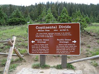
Milner Pass, elevation 10,759 ft (3,279 m) is a mountain pass in the Rocky Mountains of northern Colorado in the United States. It is located on the continental divide in the Front Range, within Rocky Mountain National Park, along the boundary between Larimer and Grand counties. The pass provides the passage over the continental divide for US 34, also known as Trail Ridge Road between Estes Park and Grand Lake. The pass is not, however, the high point on Trail Ridge Road, which crests at 12,183 ft (3,713 m) east of the pass within Rocky Mountain National Park. Along with the rest of Trail Ridge Road, the pass is generally closed in winter from the first heavy snow fall until the opening of the road around Memorial Day. The gentle pass divides the headwaters of the Cache la Poudre River and several creeks near the headwaters of the Colorado River to the west. The road near the pass provides a panoramic view of the Never Summer Mountains to the west.

Winter Park Resort is an alpine ski resort in Winter Park, Colorado in the Rocky Mountains. Located just off U.S. Highway 40, the resort is about a 90-minute drive from Denver, Colorado.

Yosemite West is an unincorporated community of resort homes located just outside the southern area of Yosemite National Park, just off Wawona Road, a continuation of State Route 41 from Fresno. It is situated one mile (1.6 km) south of the Chinquapin intersection of Wawona Road with Glacier Point Road at an altitude of 5,100–6,300 ft (1,600–1,900 m). The elevation reported by the USGS is 5,866 feet (1,788 m). The community is part of Henness Ridge, nearly 3,000 feet (910 m) above the southern banks of the Merced River and State Route 140 from Mariposa.
The Mount Tom Range is a traprock mountain range located in the Connecticut River Valley of Massachusetts. It is part of the Metacomet Ridge that extends from Long Island Sound near New Haven, Connecticut, north through the Connecticut River Valley of Massachusetts to nearly the Vermont border. A popular outdoor recreation resource, the range is known for its continuous west facing cliffs and its rugged, scenic character. It is also notable for its unique microclimate ecosystems and rare plant communities, as well as significant historic sites, such as the ruins of the 18th century Eyrie House located on Mount Nonotuck.
Besek Mountain also known as Black Mountain, est. 840 feet (260 m), is a traprock mountain ridge located 4.75 miles (7.6 km) southeast of Meriden, Connecticut. It is part of the narrow, linear Metacomet Ridge that extends from Long Island Sound near New Haven, Connecticut, north through the Connecticut River Valley of Massachusetts to the Vermont border. Besek Mountain is known for its 3-mile (4.8 km) long line of open cliffs, unique microclimate ecosystems, and rare plant communities. The mountain is traversed by the 51-mile (82 km) Mattabesett Trail, and is home to the Powder Ridge Ski Area.
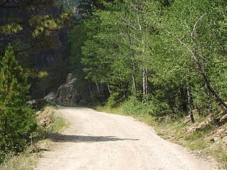
The Old Fall River Road, sometimes referred to as "The Old Road" by park staff in Rocky Mountain National Park, was the first automobile road to penetrate the interior of the park. The road linked the east side of the park near Estes Park with Grand Lake on the west side. Work began in 1913 but was interrupted in 1914 by World War I with final work being completed between 1918 and 1920.
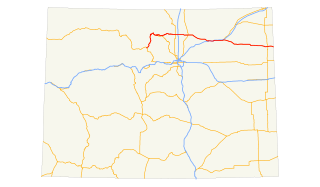
U.S. Route 34 (US 34) is a part of the U.S. Highway System that travels from Granby, Colorado, to Berwyn, Illinois. In the U.S. state of Colorado, US 34 is a 260-mile-long (420 km) road that spans across northern Colorado. It begins at US 40 in Granby and ends at the Nebraska border, where it continues as US 34, east of Laird.
The Holzwarth Historic District comprises a series of cabins built by the Holzwarth family as a guest ranch inholding within the boundaries Rocky Mountain National Park, at Grand Lake, Colorado. The Holzwarths made their homestead in the Kawuneeche Valley in 1917, two years after the establishment of the park, and received a patent on the homestead in 1923. Guest ranch use began in 1919 and continued until the ranch was purchased by The Nature Conservancy in 1974. The property was transferred to the National Park Service in 1975 for incorporation into the park. The district comprises a number of rustic cabins on the Colorado River. Operations existed on both sides of the river, first known as the Holzwarth Trout Ranch and later as the Never Summer Ranch. All but Joe Fleshut's cabin have been removed from the east side of the river.

Kawuneeche Valley, also known as Kawuneeche or Coyote Valley, is a marshy valley of the Colorado River near its beginning. It is located on the west side of Rocky Mountain National Park in Colorado. The axis of the valley runs almost directly north to south. Kawuneeche means "valley of the coyote" in Arapaho language and there is a Coyote Valley Trail head by US Route 34 in the western half of the park. Coyotes still live here, as do wapiti (elk), mule deer, moose, and mountain lion.

Bierstadt Lake is located in Larimer County, Colorado and within the Rocky Mountain National Park. Near McHenrys Peak and Longs Peak, there are "spectacular views" of the Continental Divide at the lake. The Bierstadt Lake Trailhead is located about 6.5 miles (10.5 km) from the turn-off at U.S. Route 36 into the Rocky Mountain National Park. During the summer, shuttle buses provide transportation to the trailhead.
History of Rocky Mountain National Park began when Paleo-Indians traveled along what is now Trail Ridge Road to hunt and forage for food. Ute and Arapaho people subsequently hunted and camped in the area. In 1820, the Long Expedition, led by Stephen H. Long for whom Longs Peak was named, approached the Rockies via the Platte River. Settlers began arriving in the mid-1800s, displacing the Native Americans who mostly left the area voluntarily by 1860, while others were removed to reservations by 1878.

Horseshoe Park is a flat at 8,524 feet (2,598 m) in elevation in Larimer County, Colorado. It is within the Rocky Mountain National Park, which lies between Estes Park to the east and Grand Lake, Colorado on the west. Horseshoe Park is home to bighorn sheep, elk and other wildlife, and it is a wetland sanctuary for wide variety of birds. Recreational activities include picnicking, hiking, cross-country skiing and snowshoeing. Roaring River, Lawn Lake and Crystal Lake are located here.

Upper Beaver Meadows is a montane meadow and visitor attraction in Rocky Mountain National Park in Colorado. The area is known as a good bird-watching spot and its trail leads to a number of other trails within the park. The trails may be used for hiking, snowshoeing, or cross-country skiing.


