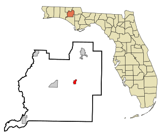
High Hill, at 323 feet (98.5 m) above sea level, is considered to be the third highest elevation in the state of Florida, USA. It is close to Oak Hill (331ft), the state's second highest point.
Florida is the southernmost contiguous state in the United States. The state is bordered to the west by the Gulf of Mexico, to the northwest by Alabama, to the north by Georgia, to the east by the Atlantic Ocean, and to the south by the Straits of Florida. Florida is the 22nd-most extensive, the 3rd-most populous, and the 8th-most densely populated of the U.S. states. Jacksonville is the most populous municipality in the state and the largest city by area in the contiguous United States. The Miami metropolitan area is Florida's most populous urban area. Tallahassee is the state's capital.
High Hill is located three miles (5km) north of Wausau, and four miles (6km) east of Vernon. High Hill, Oak Hill, and the 250-foot-high (76m) peak of Sand Mountain are located in Washington County.
Wausau is a town in Washington County, Florida, United States.
Vernon is a city in Washington County, Florida, United States. The population was 743 at the 2000 census; according to the U.S. Census Bureau's 2004 estimates, the city had a population of 757.
At 76 meters above sea level, Sand Mountain is one of the highest points in the state of Florida. Sand Mountain is located near the Floridian town of Wausau.
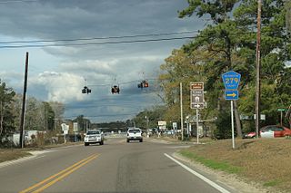
The easiest way to get there is by car via Washington County Road 278.
A geographic coordinate system is a coordinate system that enables every location on Earth to be specified by a set of numbers, letters or symbols. The coordinates are often chosen such that one of the numbers represents a vertical position and two or three of the numbers represent a horizontal position; alternatively, a geographic position may be expressed in a combined three-dimensional Cartesian vector. A common choice of coordinates is latitude, longitude and elevation. To specify a location on a plane requires a map projection.
This page is based on this Wikipedia article Text is available under the CC BY-SA 4.0 license; additional terms may apply. Images, videos and audio are available under their respective licenses.
Related Research Articles
Washington County is a county located in the state of Florida. As of the 2010 census, the population was 24,935. Its county seat is Chipley. Washington County is a prohibition or entirely dry county, meaning that the sale of alcoholic beverages is banned in the county.
DeKalb County is a county of the U.S. state of Alabama. As of the 2010 census, the population was 71,109. Its county seat is Fort Payne and it is named after Major General Baron Johan DeKalb.
Washington County is a county located in the U.S. state of Tennessee. As of the 2010 census, the population was 122,979. Its county seat is Jonesborough. The county's largest city and a regional educational, medical and commercial center is Johnson City. Washington County is Tennessee's oldest county, having been established in 1777 when the state was still part of North Carolina.
AlleghanyCounty is a county located in the U.S. state of North Carolina. As of the 2010 census, the population was 11,155. Its county seat is Sparta.
Oak Hill is a town in Wilcox County, Alabama, United States. According to the 1940 U.S. Census, it incorporated in 1938. The population was 26 at the 2010 census, down from 37 in 2000. It is the second smallest incorporated town in Alabama as of 2010, behind McMullen. However, the smallest unincorporated census-designated place in the state is also located in Wilcox County, that of Catherine, which had 22 residents as of 2010. With a median household income of $9,286, Oak Hill is the poorest community in Alabama.
Peninsula Township is a civil township of Grand Traverse County in the U.S. state of Michigan. As of the 2010 census, the township population was 5,433, up from 5,265 at the 2000 census. The township is coterminous with the Old Mission Peninsula, which projects into the Grand Traverse Bay of Lake Michigan. The Old Mission Point Lighthouse is located at the northern end of the peninsula. The peninsula is included in the Old Mission Peninsula AVA, an American Viticultural Area known for its Michigan wine. The Grand Traverse region has two of Michigan's four federally recognized wine growing areas.
Oak Hill is a city in Davidson County, Tennessee. The population was 4,529 at the 2010 census. The Tennessee Governor's Mansion is located in the city. Although the city is administered under the Metropolitan Government of Nashville and Davidson County, it retains its own municipal government. It is considered a wealthy suburb of Nashville.
Pecan Hill is a city in Ellis County, Texas, United States. The population was 626 at the 2010 census, down from 672 at the 2000 census.
The Boston Mountains is a Level III ecoregion designated by the Environmental Protection Agency (EPA) in the U.S. states of Arkansas and Oklahoma. Part of the Ozark Mountains, the Boston Mountains are a deeply dissected plateau. The ecoregion is steeper than the adjacent Springfield Plateau to the north, and bordered on the south by the Arkansas Valley. The Oklahoma portion of the range is locally referred to as the Cookson Hills.
Rock Hill is a high point in Florida. This hill is located in Walton County, Florida. The hill is 193 feet high. Just outside Eglin Air Force Base, Rock Hill is 5 miles (8.0 km) north of Freeport, Florida; and is 7 miles (11 km) south of DeFuniak Springs, Florida, near the intersection of U.S. Route 331 and State Road 20. Its exact location is 30°36'2"N 86°6'22"W.
Burgess Falls State Park is a state park and state natural area in Putnam County and White County, Tennessee, located in the southeastern United States. The park is situated around a steep gorge in which the Falling Water River drops 250 feet (76 m) in elevation in less than a mile, culminating in a 136-foot (41 m) cataract waterfall.
Tanner is an unincorporated community in central southern Limestone County, Alabama, United States, and is included in the Huntsville-Decatur Combined Statistical Area. It lies nine miles north of the city of Decatur and the Tennessee River, and four miles south of the city of Athens.
Polk Township is one of thirteen townships in Washington County, Indiana, United States. As of the 2010 census, its population was 2,626 and it contained 1,131 housing units.
Brace Mountain is the peak of a ridge in the southern Taconic Mountains, near the tripoint of the U.S. states of New York, Connecticut and Massachusetts. Its 2,311-foot (704 m) main summit is located in New York; it is the highest point in that state's Dutchess County.
Jayhawk is an unincorporated community in El Dorado County, California. It is located 6.5 miles (10 km) southwest of Coloma, at an elevation of 1161 feet.
Raton Mesa is the collective name of several mesas on the eastern side of Raton Pass in New Mexico and Colorado. The name Raton Mesa or Mesas has sometimes been applied to all the mesas that extend east for 90 miles (140 km) along the Colorado-New Mexico border from Raton, New Mexico and Trinidad, Colorado to the Oklahoma panhandle. These include Johnson Mesa, Mesa de Maya, and Black Mesa.
The Beezley Hills are a range of hills, about 5 miles (8.0 km) north of Quincy in Grant County, Washington with a maximum elevation of 2,882 feet (878 m) or 2,886 feet (879.7 m).