Viljakkala is a former municipality of Finland.
Mäntymäki is a district of the city of Turku, in Finland. It is located to the south of the city centre, between Kurjenmäki and Vähäheikkilä.

Nidau District is one of the 26 administrative districts in the canton of Bern, Switzerland. Its capital, while having administrative power, was the municipality of Nidau.

Kinaskan Lake Provincial Park is a provincial park in British Columbia, Canada, located at the south end of Kinaskan Lake along the Stewart-Cassiar Highway near Mowdade Lake and southeast of Mount Edziza. At the south end of the park, the Iskut River, of which the lake is an expansion, spills over 12.2-metre Cascade Falls. The park is approximately 800 ha. in size.
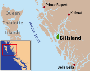
Gil Island is an island on the North Coast of British Columbia, Canada, located on the west side of Whale Channel in the entrance to Douglas Channel, one of the main coastal inlets, on the route of the Inside Passage between Pitt Island and Princess Royal Island. It is 26 km (16 mi) long, with a width ranging from 6 to 13 km, and an area of 231 km2. The only named summit on the mountainous island is Mount Gil, which faces the opening of Douglas Channel.
Surge Narrows Provincial Park is a provincial park in British Columbia, Canada, located on the south tip of Maurelle Island and on adjacent islands in the Discovery Islands archipelago in that province's South Coast region.
Matak is an island in the Anambas Islands of Indonesia, located in the South China Sea between the Malay Peninsula and Borneo. The island is a base for oil companies including ConocoPhillips, Premier Oil and Star Energy, and is served by Matak Airport (MWK/WIOM). The population of Matak Island is estimated to be in the range of 1500–2500. Residents usually work for the oil companies located on the island. There are also factories on the island, such as Kosel Yamato.

The Gwa'Sala-Nakwaxda'xw Nations are a union of two Kwakwaka'wakw peoples in a band government based on northern Vancouver Island in British Columbia, Canada, whose main reserve community is near the town of Port Hardy in the Queen Charlotte Strait region of the Central Coast region of British Columbia, Canada. The band government is a member of the Kwakiutl District Council and, for treaty negotiation purposes, the Winalagalis Treaty Group which includes three other members of the Kwakiutl District Council.
The Lytton First Nation, a First Nations band government, has its headquarters at Lytton in the Fraser Canyon region of the Canadian province of British Columbia. While it is the largest of all Nlaka'pamux bands, unlike all other governments of the Nlaka'pamux (Thompson) people, it is not a member of any of the three Nlaka'pamux tribal councils, which are the Nicola Tribal Association, the Fraser Canyon Indian Administration and the Nlaka'pamux Nation Tribal Council.
The Tŝideldel First Nation is the band government of the Tsi Del Del subgroup of the Tsilhqot'in people, located in the Chilcotin District in the western Central Interior region of the Canadian province of British Columbia. It is a member of the Tsilhqot'in National Government.
The Tlʼetinqox-tʼin Government Office is a First Nations government located in the Chilcotin District in the western Central Interior region of the Canadian province of British Columbia. Governing a reserve communities near Alexis Creek known as Anaham Reserve First Nations or Anaham, it is a member of the Tsilhqotʼin Tribal Council aka known as the Tsilhqotʼin National Government. The main reserve is officially known as Anahim's Flat No. 1, and is more commonly as Anaham. Other reserves are Anahim's Meadow No. 2 and 2A, and Anahim Indian Reserves Nos. 3 through 18. Anaham, or Anahim and Alexis were chiefs of the Tsilhqotʼin during the Chilcotin War of 1864, although they and their people did not take part in the hostilities.

Almunia de San Juan is a municipality located in the province of Huesca, Aragon, Spain. According to the 2004 census (INE), the municipality has a population of 660 inhabitants.
Perarrúa, in Ribagorçan and Aragonese: Perarruga is a municipality located in the province of Huesca, Aragon, Spain. According to the 2004 census (INE), the municipality has a population of 123 inhabitants.
Khaglan Wala (ڪھگلانواله) is a village and union council of Isakhel Tehsil of Mianwali District in the Punjab province of Pakistan. It is part of Isa Khel Tehsil and is located at 32°37'60N 71°16'0E. Located on the northern bank of Kurram River, it is one of the villages situated on the western borders of Punjab province adjacent to KPK province. Its population is about 3000 people. This is comparatively a developed village. Basic facilities like electricity, telephone, metalled road, internet, schools, water supply system and sewerage system are provided to the inhabitants of this village. It is also a well-planned village situated on a 40 feet wide metalled road. A 30' wide main street runs east to west through the village, equally dividing the entire village into two parts. Three other streets run north to south crossing the main street at 90°. There are four mosques i.e Grand Mosque, Masjid Naurang Khel, Masjid Khizar Khel in Mohalla Khizar Khel and Masjid Abadi Tajpora in this settlement. The scene of river Kurram alongside bela jungle provides beautiful look to this historical village. Khaglanwala is hub of different routes coming from various villages situated on other side of the River Kurram, to reach Isa Khel city.
Garyala is a town and union council in Mardan District of Khyber-Pakhtunkhwa. It is located at 34°16'0N 72°13'0E and has an altitude of 317 metres.
Ragala is a town in central western Sri Lanka.
Hadhagaala or Adigala is a small town in north-eastern Ethiopia. It is served by a station on the narrow gauge Ethio-Djibouti Railways. The railway reached Adigale in 1902. The station is about 100 km inside Ethiopia from the border with Djibouti.
Breslau is an unincorporated community in Hanover Township, Luzerne County, Pennsylvania, located along the south side of the Susquehanna River. It was given the German name of the Polish city of Wrocław. The village uses the Wilkes-Barre/Hanover Township zip code of 18706.
Ghanau is a village located in the sidhmukh tahsil and Churu district of Rajasthan state in India.
Mararaba Mubi is a small town in the Hildi district of the Hong local government area of Nigeria. It predominantly consists of the Fulani tribe. It is about 15 kilometres from the town of Mubi. Its main economic activities are farming and petty trading.