
Westminster is a district in Central London, part of the wider City of Westminster.

Newington is a district of South London, just south of the River Thames, and part of the London Borough of Southwark. It was an ancient parish and the site of the early administration of the county of Surrey. It was the location of the County of London Sessions House from 1917, in a building now occupied by the Inner London Crown Court.

George Vertue was an English engraver and antiquary, whose notebooks on British art of the first half of the 18th century are a valuable source for the period.
Central London is the innermost part of London, in England, spanning several boroughs. Over time, a number of definitions have been used to define the scope of Central London for statistics, urban planning and local government. Its characteristics are understood to include a high density built environment, high land values, an elevated daytime population and a concentration of regionally, nationally and internationally significant organisations and facilities.
Johannes "Jan" Kip was a Dutch draftsman, engraver and print dealer. Together with Leonard Knyff, he made a speciality of engraved views of English country houses.

Wenceslaus Hollar was a prolific and accomplished Bohemian graphic artist of the 17th century, who spent much of his life in England. He is known to German speakers as Wenzel Hollar; and to Czech speakers as Václav HollarCzech: [ˈvaːtslav ˈɦolar]. He is particularly noted for his engravings and etchings. He was born in Prague, died in London, and was buried at St Margaret's Church, Westminster.

Thomas Malton, "the younger", was an English painter of topographical and architectural views, and an engraver. J. M. W. Turner and Thomas Girtin were amongst his pupils. He is designated "the younger" to differentiate him from his father Thomas Malton, the elder.

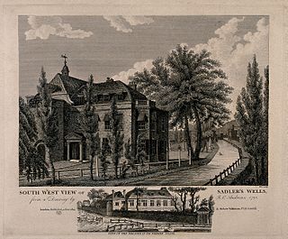
Thomas Medland was an English engraver and draughtsman. He was drawing-master at Haileybury College and exhibited at the Royal Academy. He illustrated numerous works during his lifetime and was landscape engraver to the Prince of Wales.

Bolsover Street is in the Parish of St Marylebone in London’s West End. In administrative terms it lies within the City of Westminster's Marylebone High Street Ward and is partly in the Harley Street Conservation Area whilst also sitting on the edges of the Regents Park and East Marylebone Conservation Areas.
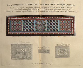
Vetusta Monumenta is the title of a published series of illustrated antiquarian papers on ancient buildings, sites and artefacts, mostly those of Britain, published at irregular intervals between 1718 and 1906 by the Society of Antiquaries of London. The folio-sized papers, usually written by members of the society, were first published individually, and then later in collected volumes.

Thomas Allen (1803–1833) was an English topographer.
John Coney (1786–1833) was an English architectural draughtsman and engraver.

John Rocque's Map of London, 1746 can refer to two different maps. The better known of these has the full name A plan of the cities of London and Westminster, and borough of Southwark: it is a map of Georgian London to a scale of 26 inches to a mile, surveyed by John Rocque, engraved by John Pine, and published in 1746. It consists of 24 sheets and measures 3.84 by 2.01 metres. Taking nearly ten years to survey, engrave and publish, it has been described as "a magnificent example of cartography ... one of the greatest and most handsome plans of any city".
Long View of London from Bankside is a panoramic etching made by Wenceslas Hollar in Antwerp in 1647. It depicts a panorama of London, based on drawings done while Hollar was in London in the early 1640s. Unlike earlier panoramas of London, Hollar's panorama takes a single viewpoint, the tower of St Saviour in Southwark, from where he made the drawings. It shows the River Thames curving sinuously from left to right past the viewpoint.
John Pass or Paas (c.1783–1832) was an English engraver and murder victim.
Bartlett's Buildings, once known as Bartlett's Court, was the name of a street, off Holborn Circus in the City of London, known for the number of lawyers who had offices there. It was a cul-de-sac but an alley ran from the west side to Fetter Lane that was known as Bartlett's Passage. It was destroyed in 1941 during a Second World War air raid.
Charles Pye Jr. was a British engraver from Birmingham. He illustrated topographical subjects, and published a Holy Family after Michelangelo.

David Hughson, which may have been a pen name of Edward Pugh, was a writer on the topography and history of London. He produced a description of the city based on "an actual perambulation" (walk) that was published in six volumes between 1805 and 1809 and contains 150 copper plate engravings principally based on illustrations by Robert Blemmell Schnebbelie and Edward Gyfford. He also produced works on topical matters such as the East India Company, religious subjects, and works of household management targeted at people of the "middling and genteel ranks of life".
Londina Illustrata. Graphic and Historic Memorials of Monasteries, Churches, Chapels, Schools, Charitable Foundations, Palaces, Halls, Courts, Processions, Places of Early Amusement and Modern & Present Theatres, In the Cities and Suburbs of London & Westminster was a book published in two volumes by Robert Wilkinson in 1819 & 1825, that had initially been released with William Herbert as groups of engravings between 1808 and 1819 which featured topographical illustrations by some of the foremost engravers and illustrators of the day, of the cities of London and Westminster, the county of Middlesex and some areas south of the River Thames, then in Surrey, such as Southwark.

West London is the western part of London, England.
