
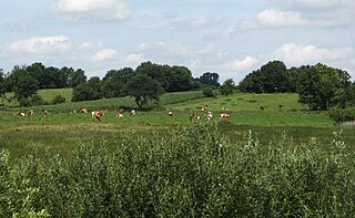
Lüneburg Heath is a large area of heath, geest, and woodland in the northeastern part of the state of Lower Saxony in northern Germany. It forms part of the hinterland for the cities of Hamburg, Hanover and Bremen and is named after the town of Lüneburg. Most of the area is a nature reserve. Northern Low Saxon is still widely spoken in the region.

The Hamme is a 48 km (30 mi) long river in Germany, Lower Saxony, north-east of Bremen. Its source is north of Osterholz-Scharmbeck. It flows through the moors north-east of Bremen called Teufelsmoor, and meets the river Wümme in Ritterhude. From this junction, the river is called Lesum. The Lesum flows into the river Weser in Bremen-Vegesack.
Geest is a type of landform, slightly raised above the surrounding countryside, that occurs on the plains of Northern Germany, the Northern Netherlands and Denmark. It is a landscape of sandy and gravelly soils formed as a glacial outwash plain and now usually mantled by a heathland vegetation on the glacial deposits left behind after the last ice age during the Pleistocene epoch.

The North German Plain or Northern Lowland is one of the major geographical regions of Germany. It is the German part of the North European Plain. The region is bounded by the coasts of the North Sea and the Baltic Sea to the north, Germany's Central Uplands to the south, by the Netherlands to the west and Poland to the east.
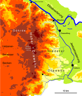
The Drawehn is a partly wooded and partly agricultural region of hills in the northeastern part of the German state of Lower Saxony, lying between the districts of Lüneburg and Uelzen in the west and Lüchow-Dannenberg in the east.

The Schleswig-Holstein Uplands or Schleswig-Holstein Morainic Uplands is one of the three landscapes of the German state of Schleswig-Holstein; the others being the marsch and the geest. In addition, the gently rolling hills or Hügelland of the Baltic Uplands, the many small lakes and the long, deep embayments (Förde) formed by the moraines of the Weichselian Ice Age are characteristic features of the area. Its best-known towns are Kiel, Lübeck and Flensburg. The highest elevation in the area is the Bungsberg in the region known as Holstein Switzerland. On the Bungsberg is the only ski lift in the state.
The Stade Geest is a natural region of low, sandy heath (geest) in the North German Plain.
The Linteln Geest, shown on some maps as the Verden Heath, is a geest region in the north German state of Lower Saxony and belongs administratively to the borough of Kirchlinteln.

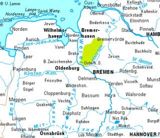
The region between the Elbe and Weser rivers forms the Elbe–Weser triangle, also rendered Elbe-Weser Triangle, in northern Germany. It is also colloquially referred to as the Nasses Dreieck or "wet triangle".

The Baltic Uplands is a chain of morainic hills about 200 kilometres (120 mi) wide that border the southern Baltic Sea from Jutland to Estonia.
The Magdeburg Börde is the central landscape unit of the state of Saxony-Anhalt and lies to the west and south of the eponymous state capital Magdeburg. Part of a loess belt stretching along the southeastern rim of the North German Plain, it is noted for its very fertile Chernozem soils.

The Heide-Itzehoe Geest is a division of a larger natural region in the west of the German state of Schleswig-Holstein. It belongs to the Hohe Geest and thus to the Schleswig-Holstein Geest natural region.
The Burgdorf-Peine Geest is a geest landscape, dominated by end and ground moraines, between Hanover and Brunswick in North Germany, with an area of about 550 square kilometres (210 sq mi). Its natural borders are the Aller depression in the north, the Hildesheim Börde and, in places, the Mittelland Canal in the south the Oker valley in the east and the Hanoverian Moor Geest in the west.
The Cloppenburg Geest is a geest region near the town of Cloppenburg in North Germany and the centre of the Saalian glaciation Upper Pleistocene terrain of the Ems-Hunte Geest region. The meltwater sands (Schmelzwassersande) of the advancing ice sheet covered the old terrain with outwash sands (Vorschüttsande). Woldstedt spoke about underlying sands that, in the "Cloppenburg-Bassum Geest", belonged to the Elster glaciation. A covering of boulder clay was deposited over the outwash sands during the Saale glaciation, or more precisely the Drenthe stage.

The Hanoverian Moor Geest is a gently rolling landscape between Hanover and Nienburg in the German state of Lower Saxony covering an area of around 800 square kilometres (310 sq mi). It belongs to the raised bog regions of northwest Germany, which cover the geest terrain formed during the ice age and which stretch from the Netherlands to the eastern border of Lower Saxony. The geest tract on the Hanoverian Moor Geest consists of a ground moraine plateau with a height of 50–85 metres (164–279 ft) above sea level that is dominated by bog. Its natural boundaries are the Aller glacial valley to the north and the Burgdorf-Peine Geest to the east.
The Osterholz Geest is an undulating, sandy area of ground moraine between the city of Bremen and the towns of Bremerhaven and Bremervörde.
Land Hadeln is a historic landscape and former administrative district in Northern Germany with its seat in Otterndorf on the Lower Elbe, the lower reaches of the River Elbe, in the Elbe-Weser Triangle between the estuaries of the Elbe and Weser.

The Sorge is a right affluent of river Eider in Schleswig-Holstein, Germany.
The Wesermünde Geest is the collective name for several geest ridges in the west of Cuxhaven district and Bremen's North Borough in northern Germany. The ridges are separated from one another by wetlands. These terminal moraines were formed during the Saale glaciation, are up to between 10 to 70 m above sea level (NN), and are covered by scattered woods and farmland. The wetland areas, between 0 to 5 m above sea level, are predominantly used for grazing.

A börde is a region of highly fertile lowland in North Germany, a "fertile plain". These landscapes often cover great areas and are particularly important for arable farming on account of their rich soils.