
The geography of Papua New Guinea describes the eastern half of the island of New Guinea, the islands of New Ireland, New Britain and Bougainville, and smaller nearby islands. Together these make up the nation of Papua New Guinea in tropical Oceania, located in the western edge of the Pacific Ocean.

Louis-Antoine, Comte de Bougainville was a French admiral and explorer. A contemporary of the British explorer James Cook, he took part in the Seven Years' War in North America and the American Revolutionary War against Britain. Bougainville later gained fame for his expeditions, including circumnavigation of the globe in a scientific expedition in 1763, the first recorded settlement on the Falkland Islands, and voyages into the Pacific Ocean. Bougainville Island of Papua New Guinea as well as the Bougainvillea flower were named after him.
Bougainville Copper Limited (BCL) is a mining company of Papua New Guinea (PNG) that is listed on the Australian Securities Exchange (ASX). BCL operated the copper, gold and silver mine at Panguna in central Bougainville in PNG from 1971 to 1989. Mining operations were officially halted on 15 May 1989, due to militant activity and the mine has remained closed since.

The Bougainville Campaign was a series of land and naval battles of the Pacific campaign of World War II between Allied forces and the Empire of Japan. It was part of Operation Cartwheel, the Allied grand strategy in the South Pacific. The campaign took place in the Northern Solomons in two phases. The first phase, in which American troops landed and held the perimeter around the beachhead at Torokina, lasted from November 1943 through November 1944. The second phase, in which primarily Australian troops went on the offensive, mopping up pockets of starving, isolated but still-determined Japanese, lasted from November 1944 until August 1945, when the last Japanese soldiers on the island surrendered. Operations during the final phase of the campaign saw the Australian forces advance north towards the Bonis Peninsula and south towards the main Japanese stronghold around Buin, although the war ended before these two enclaves were completely destroyed.
The Shortland Islands are a group of islands belonging to the Western Province of the Solomon Islands, at 6.92°S 155.88°E. Named by John Shortland, they lie in the extreme northwest of the country's territory, close to the island of Bougainville, Papua New Guinea. The largest island is Shortland Island. Other islands include Balalae Island, Ovau Island, Pirumeri Island, Faisi Island, Magusaiai Island, Masamasa Island, Fauro Island, and Ballale Island.

Panguna is a town and a copper mine on Bougainville Island, Papua New Guinea. It was owned and operated by Bougainville Copper Ltd, a subsidiary of Rio Tinto. Beginning operations in 1972, the company hired thousands of workers, most from other parts of the country.

Empress Augusta Bay is a bay on the western side of the island of Bougainville Island, within the Autonomous Region of Bougainville in northeastern Papua New Guinea.
Cape Torokina is a promontory at the north end of Empress Augusta Bay, along the central part of the western coast of Bougainville, in Papua New Guinea.
Treasury Islands are a small group of islands a few kilometers to the south of Bougainville and 24 kilometres from the Shortland Islands. They form part of the Western Province of the Solomon Islands. The two largest islands in the Treasuries are Mono Island and the smaller Stirling Island. The deep water strait between these two islands is called Blanche Harbor.

The Northern Solomons were the more northerly group of islands in the Solomon Islands archipelago over which Germany declared a protectorate in 1885. Initially the German Solomon Islands Protectorate included Choiseul, Santa Isabel, the Shortlands and Ontong Java Islands, but in 1900 these islands were transferred to the British Solomon Islands Protectorate. The largest of the Solomon Islands, Bougainville, continued under German administration until World War I when it fell to Australia, and after the war, it formally passed to Australian jurisdiction under a League of Nations mandate.

The Torokina River is a river on Bougainville Island, within the Autonomous Region of Bougainville, in northeastern Papua New Guinea.
Jaba River is a river in Bougainville, Papua New Guinea. It empties to Empress Augusta Bay at 6.3833333°S 155.2166667°E. It was polluted by waste from the Panguna copper mine. Jaba river was polluted with sediments and heavy metals dumped from Copper mine. The aquatic life of Jaba river was destroyed due to heavy metal pollution. The environmental pollution of river was one of the causes of armed conflict on the island and struggle of local people for independence.
Stirling Island is the smaller island of the Treasury Islands, Solomon Islands.
Torokina is a coastal village on Bougainville Island, in the Autonomous Region of Bougainville, eastern Papua New Guinea.
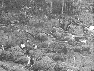
The Raid on Koiari was a battle that occurred between 28–29 November 1943 in the Pacific theater of World War II between American and Japanese forces. Part of the Bougainville campaign, the raid involved a landing by a battalion-sized force of United States Marines to harass Imperial Japanese Army troops on Bougainville Island. The raid was a failure for the Americans as they were attacked by a larger-than-expected Japanese force and as a result the Marines were withdrawn from the beachhead without having achieved any of their objectives.
The Piva River is a river on the south western coast of Bougainville.

Central Bougainville District is a district of the Autonomous Region of Bougainville of Papua New Guinea. Its capital is Arawa-Kieta.
South Bougainville District is a district of the Autonomous Region of Bougainville of Papua New Guinea. Its capital is Buin.
The Atara River is a river on southeastern Bougainville Island.


