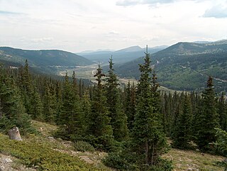
Hoosier Pass may refer to:

Teller County is a county located in the U.S. state of Colorado. As of the 2010 census, the population was 23,350. The county seat is Cripple Creek, and the most populous city is Woodland Park.
Fremont Pass may mean one of the following:
Independence Pass may refer to:

Hoosier Pass is a high mountain pass in central Colorado, in the Rocky Mountains of the western United States. The name derives from Indiana, nicknamed the "Hoosier State," which was the original home of many pioneers.

Divide is an unincorporated town, a post office, and a census-designated place (CDP) located in and governed by Teller County, Colorado, United States. The CDP is a part of the Colorado Springs, CO Metropolitan Statistical Area. The Divide post office has the ZIP Code 80814. At the United States Census 2010, the population of the Divide CDP was 127, while the population of the 80814 ZIP Code Tabulation Area was 4,023 including adjacent areas.
Ptarmigan is the common name of birds of the genus Lagopus
Deer Creek Trail lies along the Continental Divide of the Americas, part of the Rocky Mountains in the U.S. state of Colorado. It is located in the White River National Forest, Summit County. Deer Creek Trail is south of Colorado Highway 6, east of Keystone Resort and near Montezuma.
Arapaho Pass may refer to:
Ptarmigan Pass may refer to:
Red Mountain Pass may be one of the following:
Buffalo Pass may refer to:
French Pass may refer to:
Cottonwood Pass may refer to:
Muddy Pass may refer to:
San Luis Pass may refer to:
Summit Pass may refer to:
Thunder Pass may refer to:
Webster Pass may refer to:
Ute Pass may refer to: