See also
55°28′00″N60°13′00″W / 55.46667°N 60.21667°W
| | This Labrador location article is a stub. You can help Wikipedia by expanding it. |
Hopewell was a small village located south west of St. John's. It had a population of 221 in 1956.
55°28′00″N60°13′00″W / 55.46667°N 60.21667°W
| | This Labrador location article is a stub. You can help Wikipedia by expanding it. |
East Pine Provincial Park is a provincial park in British Columbia, Canada, located east of Chetwynd in the Peace River Block at the junction of the Pine and Murray Rivers. The park was established in 1982 and is 14.2 hectares in size.
Kluskoil Lake Provincial Park is a provincial park in British Columbia, Canada, located on the West Road River downstream from the Euchiniko Lakes.

Saltery Bay Provincial Park is a provincial park in British Columbia, Canada, located southeast of the city of Powell River, and on the north side of the entrance to Jervis Inlet in the central area of that province's Sunshine Coast region.

The Gwa'Sala-Nakwaxda'xw Nations are a union of two Kwakwaka'wakw peoples in a band government based on northern Vancouver Island in British Columbia, Canada, whose main reserve community is near the town of Port Hardy in the Queen Charlotte Strait region of the Central Coast region of British Columbia, Canada. The band government is a member of the Kwakiutl District Council and, for treaty negotiation purposes, the Winalagalis Treaty Group which includes three other members of the Kwakiutl District Council.

The Stswecem'c Xgat'tem First Nation, formerly known as Canoe Creek Band/Dog Creek Indian Band, created as a result of merger of the Canoe Creek Band and Dog Creek Band is a First Nations government of the Secwepemc (Shuswap) Nation, located in the Fraser Canyon-Cariboo region of the Central Interior of the Canadian province of British Columbia. It was created when the government of the then-Colony of British Columbia established an Indian reserve system in the 1860s. It is a member government of the Northern Shuswap Tribal Council.
The Tŝideldel First Nation is the band government of the Tsi Del Del subgroup of the Tsilhqot'in people, located in the Chilcotin District in the western Central Interior region of the Canadian province of British Columbia. It is a member of the Tsilhqot'in National Government.
The Tlʼetinqox-tʼin Government Office is a First Nations government located in the Chilcotin District in the western Central Interior region of the Canadian province of British Columbia. Governing a reserve communities near Alexis Creek known as Anaham Reserve First Nations or Anaham, it is a member of the Tsilhqotʼin Tribal Council aka known as the Tsilhqotʼin National Government. The main reserve is officially known as Anahim's Flat No. 1, and is more commonly as Anaham. Other reserves are Anahim's Meadow No. 2 and 2A, and Anahim Indian Reserves Nos. 3 through 18. Anaham, or Anahim and Alexis were chiefs of the Tsilhqotʼin during the Chilcotin War of 1864, although they and their people did not take part in the hostilities.

The French submarine Rubis was a Saphir-class minelaying submarine which first served in the French submarine pavilion, then the Free French Naval Forces (FNFL) during the Second World War and back with the French Navy. The boat was awarded numerous awards. Accordingly, as a result of Rubis's service with the FNFL, the boat was made a companion of the Ordre de la Libération by a decree issued by General Charles de Gaulle on 14 October 1941.
French Bar Canyon is a canyon on the Fraser River in British Columbia, Canada, near Big Bar and Jesmond, and approximately 60 km upstream from Lillooet.

The Pashleth Glacier is a glacier south of the Machmell River and west of the Klinaklini Glacier in southwestern British Columbia, Canada.
Holy Cross National Forest was established as the Holy Cross Forest Reserve by the U.S. Forest Service in Colorado on August 25, 1905 with 990,720 acres (4,009.3 km2). It became a National Forest on March 4, 1907. On August 7, 1920 Sopris National Forest was absorbed. On January 1, 1945 the entire forest was transferred to White River National Forest and the name was discontinued.
Otter Lake is the nane of a number of lakes, rives and a community in Nova Scotia).
The Kitsault River is a river on the North Coast of British Columbia, Canada, located at the head of Alice Arm, which is the east arm of Observatory Inlet, which is itself an arm of Portland Inlet. Located at the mouth of the river are the localities of Alice Arm, Kitsault and Gits'oohl, a community of the Nisga'a people which was the Gitzault Indian Reserve No. 24 prior to the Nisga'a Treaty.
MV British Prudence was a tanker built by Sir James Laing & Sons Ltd. of Sunderland in 1939 and operated by the British Tanker Company. A U-boat sank her in 1942 off the coast of Newfoundland. She was a victim of the Second Happy Time: the Kriegsmarine's Operation Drumbeat to sink Allied merchant shipping in the Western Atlantic
The Taku River Tlingit First Nation are the band government of the Inland Tlingit in far northern British Columbia, Canada and also in Yukon. They comprise two ḵwaan (tribes) of the Tlingit people, who are otherwise coastal, the Áa Tlein Ḵwáan of the Atlin Lake area and the Deisleen Ḵwáan of Teslin Lake, whose main focus is the Teslin Tlingit Council in Teslin, Yukon. Their band offices are in Atlin, British Columbia.
Stony Beach is a hamlet in the Canadian province of Saskatchewan.

The Irtysh–Karaganda Canal is an irrigation canal in Kazakhstan. It connects the Irtysh River with Karaganda (Qaraghandy), a major industrial center in north-central Kazakhstan. After Kazakhstan's independence, the canal was officially renamed as the Kanysh Satpayev Canal after the Kazakh geologist Kanysh Satpayev.
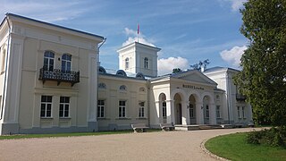
Burbiškis Manor is a former residential manor and park in Burbiškis, Anykščiai District Municipality, near the Anykšta river, built in 1853–1857. On March 4, 2015 the manor was opened after the reconstruction.