Related Research Articles

Warwick is a city in Kent County, Rhode Island, United States, and is the third-largest city in the state, with a population of 82,823 at the 2020 census. Warwick is located approximately 12 miles (19 km) south of downtown Providence, Rhode Island, 63 miles (101 km) southwest of Boston, Massachusetts, and 171 miles (275 km) northeast of New York City.
Potowomut is an isolated neighborhood and a peninsula in Warwick, Rhode Island. It is bordered by the Town of East Greenwich to the northwest, and by North Kingstown to the southeast. Greenwich Bay surrounds all other sides.

The Pawcatuck River is a river in the US states of Rhode Island and Connecticut flowing approximately 34 miles (55 km). There are eight dams along the river's length. USS Pawcatuck was named after the river.

Route 37 is a state highway running 3.47 miles (5.58 km) in Providence County and Kent County, Rhode Island, United States. A freeway for its entire length, it serves the cities of Cranston and Warwick and is also a major east–west freeway in the Providence metropolitan area, linking T. F. Green Airport with Interstate 295. The western terminus of Route 37 is an at-grade intersection with Natick Avenue in Cranston. The freeway has numbered interchanges with I-295, Rhode Island Route 2, Pontiac Avenue, and I-95 before terminating at a trumpet interchange with U.S. Route 1 in Warwick.
Newport Creamery is a chain of restaurants in Rhode Island and southern Massachusetts. Since its first restaurant opened in 1940, it has been primarily known for ice cream and, later, the "Awful Awful" milkshake. The company is based in Middletown, Rhode Island.

Hillsgrove, originally Hill's Grove, is a village in western central Warwick, Rhode Island.

Apponaug is a neighborhood in central Warwick, Rhode Island, United States, situated on Apponaug Cove, a tributary to Greenwich Bay and nearby Narragansett Bay. The name Apponaug is a derivation of the Narragansett Indian word for "place of oysters". Indeed, Apponaug Cove holds one of the richest shellfish beds in the United States and was densely populated by the Narragansett people for many centuries prior to the arrival of European settlers.

Cowesett is a hillside neighborhood located in Warwick, Rhode Island.
Norwood is a neighborhood in the city of Warwick, Rhode Island. Norwood is bounded by Route 37, the Pawtuxet River, Elmwood Avenue, and Post Road. Such borders mark the area traditionally served by the fire station previously located at the current site of the Norwood Boys & Girls Club.
The Sevenmile River or Seven Mile River is a river which flows through U.S. states of Massachusetts and Rhode Island. It flows approximately 9.8 miles (15.8 km).
The Runnins River is a river in the U.S. states of Massachusetts and Rhode Island. It flows approximately 14 km (9 mi).
The Potowomut River is a tidal extension of the Hunt River in the U.S. state of Rhode Island. It runs approximately 2.5 miles (4.0 km).
The Maskerchugg River is a river in the U.S. state of Rhode Island. It flows approximately 4 miles (6.4 km).
The Maidford River is a river in the U.S. state of Rhode Island. It flows 4.1 miles (6.6 km). There is one dam along the river's length.
The Hunt River is a river in the U.S. state of Rhode Island. It flows approximately 11 km (7 mi). There is a small stone dam just upstream from the Davisville Road bridge that powered a woolen mill active in the period 1811–1924.

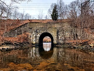
The North Branch Pawtuxet River is a river in the U.S. state of Rhode Island. It flows approximately 8.9 miles (14.3 km). There are 9 dams along the river's length.
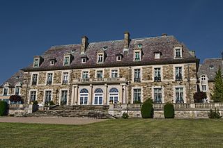
Aldrich Mansion is a late 19th-century property owned by the Roman Catholic Diocese of Providence since 1939. It is located by the scenic Narragansett Bay at 836 Warwick Neck Avenue in Warwick, Rhode Island, south of Providence, Rhode Island. Originally called Indian Oaks, and once the Senator Nelson W. Aldrich Estate. The extensive estate was developed in 1899 by Nelson W. Aldrich (1841–1915), a Republican Party politician who dominated state politics of the period. The main estate house is a sprawling stone French Renaissance structure with lavish interior decoration. The estate's surviving outbuildings include a boathouse and a caretaker's house, the latter located across Warwick Neck Avenue from the main estate. Aldrich's heirs sold the property to the Roman Catholic church in 1939, and it was adapted for use as a seminary. The property now known as "The Aldrich Mansion" still belongs to the Diocese of Providence, and is now available as a site for weddings, formal occasions, business conferences, etc. It is also occasionally used for film and television productions.

Interstate 895 was a proposed Interstate Highway in Rhode Island and Massachusetts that would have supplemented Interstate 295 to create a full beltway around Providence.
Lincoln Park is a neighborhood in Warwick, Rhode Island. It was established early in the twentieth century.
East Natick is a small village in Warwick, Rhode Island. It is centered on the intersection of Bald Hill Road and East Avenue.
References
41°43′59″N71°24′39″W / 41.73306°N 71.41083°W
| | This Rhode Island state location article is a stub. You can help Wikipedia by expanding it. |