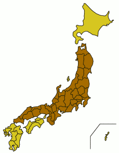
Honshu is the largest and most populous island of Japan, located south of Hokkaido across the Tsugaru Strait, north of Shikoku across the Inland Sea, and northeast of Kyushu across the Kanmon Straits. The island separates the Sea of Japan, which lies to its north and west, from the North Pacific Ocean to its south and east. It is the seventh-largest island in the world, and the second-most populous after the Indonesian island of Java.

The Øresund or Öresund Bridge is a combined railway and motorway bridge across the Øresund strait between Sweden and Denmark. The bridge runs nearly 8 kilometres from the Swedish coast to the artificial island Peberholm in the middle of the strait. The crossing is completed by the 4-kilometre (2.5 mi) Drogden Tunnel from Peberholm to the Danish island of Amager.
The Spanning Tree Protocol (STP) is a network protocol that builds a loop-free logical topology for Ethernet networks. The basic function of STP is to prevent bridge loops and the broadcast radiation that results from them. Spanning tree also allows a network design to include backup links to provide fault tolerance if an active link fails.

In general relativity, a white hole is a hypothetical region of spacetime which cannot be entered from the outside, although matter and light can escape from it. In this sense, it is the reverse of a black hole, which can only be entered from the outside and from which matter and light cannot escape. White holes appear in the theory of eternal black holes. In addition to a black hole region in the future, such a solution of the Einstein field equations has a white hole region in its past. However, this region does not exist for black holes that have formed through gravitational collapse, nor are there any known physical processes through which a white hole could be formed. Although information and evidence regarding white holes remains inconclusive, the 2006 GRB 060614 has been proposed as the first documented occurrence of a white hole.

The New York metropolitan area is the largest metropolitan area in the world by urban landmass, at 4,495 sq mi (11,640 km2). The metropolitan area includes New York City, Long Island, and the Mid and Lower Hudson Valley in the state of New York; the five largest cities in New Jersey: Newark, Jersey City, Paterson, Elizabeth, and Edison, and their vicinities; six of the seven largest cities in Connecticut: Bridgeport, New Haven, Stamford, Waterbury, Norwalk, and Danbury, and their vicinities.

South London is the southern part of London, England. Situated south of the River Thames, it includes the historic districts of Southwark, Lambeth, Bankside and Greenwich.

Southern Illinois is the southern third of the state of Illinois. The southern part of Illinois has a unique cultural and regional history. Part of downstate Illinois, the Southern Illinois region is bordered by the two most voluminous rivers in the United States: the Mississippi River and its connecting Missouri River to the west, and the Ohio River to the east and south with the Wabash as tributary.

Ayeyarwady Region, is a region of Myanmar, occupying the delta region of the Ayeyarwady River. It is bordered by Bago Region to the north, Bago Region and Yangon Region to the east and the Bay of Bengal to the south and west. It is contiguous with the Rakhine State in the northwest.

Northeast India is the easternmost region of India representing both a geographic and political administrative division of the country. It comprises eight states – Arunachal Pradesh, Assam, Manipur, Meghalaya, Mizoram, Nagaland, Sikkim, and Tripura. The Siliguri Corridor in West Bengal, with a width of 21 to 40 kilometres, connects the North Eastern Region with East India. The region shares an international border of 5,182 kilometres (3,220 mi) with several neighbouring countries – 1,395 kilometres (867 mi) with Tibet Autonomous Region, China in the north, 1,640 kilometres (1,020 mi) with Myanmar in the east, 1,596 kilometres (992 mi) with Bangladesh in the south-west, 97 kilometres (60 mi) with Nepal in the west, and 455 kilometres (283 mi) with Bhutan in the north-west. It comprises an area of 262,230 square kilometres (101,250 sq mi), almost 8 percent of that of India, and is one of the largest salients (panhandles) in the world.

The Hooghly River or the Bhāgirathi-Hooghly, traditionally called 'Ganga', and also called Kati-Ganga, is an approximately 260-kilometre-long (160 mi) distributary of the Ganges River in West Bengal, India. The Ganges splits into the Padma and the Hooghly near Giria, Murshidabad. Today there is a further man-made bifurcation of the river upstream at Farakka. The Padma flows eastward into Bangladesh, whereas the Hooghly flows south through West Bengal. The river flows through the Rarh region, the lower deltaic districts of West Bengal, and eventually into the Bay of Bengal. The upper riparian zone of the river is called Bhagirathi while the lower riparian zone is called Hooghly. Major rivers that drain into the Bhagirathi-Hooghly include Mayurakshi, Jalangi, Ajay, Damodar, Rupnarayan and Haldi rivers other than the Ganges. Calcutta and Hugli-Chinsura, the headquarter of Hooghly (district), is located on the banks of this river.

South Texas is a region of the U.S. state of Texas that lies roughly south of—and sometimes including—San Antonio. The southern and western boundary is the Rio Grande, and to the east it is the Gulf of Mexico. The population of this region is about 4.96 million according to the 2017 census estimates. The southern portion of this region is often referred to as the Rio Grande Valley. The eastern portion along the Gulf of Mexico is also referred to as the Coastal Bend.

South Hampton Roads is a region located in the extreme southeastern portion of Virginia's Tidewater region in the United States with a total population of 1,191,937. It is part of the Virginia Beach-Norfolk-Newport News, VA-NC MSA, which itself has a population of 1,724,876.
The Yangtze River Delta or YRD is a triangle-shaped metropolitan region generally comprising the Wu Chinese-speaking areas of Shanghai, southern Jiangsu province and northern Zhejiang province. The area lies in the heart of the Jiangnan region, where Yangtze River drains into the East China Sea. The urban build-up in the area has given rise to what may be the largest concentration of adjacent metropolitan areas in the world. It covers an area of 99,600 square kilometres (38,500 sq mi) and is home to over 115 million people as of 2013, of which an estimated 83 million is urban. If based on the greater Yangtze River Delta zone, it has over 140 million people in this region. With about 1/10 of China's population and 1/5 of the country's GDP, the YRD is one of the fastest growing and richest regions in East Asia measured by purchasing power parity. Having a fertile soil, the Yangtze River Delta abundantly produces grain, cotton, hemp and tea. In 2018, the Yangtze River Delta had a GDP of approximately US$2.2 trillion, about the same size as Italy.

The Great Southern Region is one of the nine regions of Western Australia, as defined by the Regional Development Commissions Act 1993, for the purposes of economic development. It is a section of the larger South Coast of Western Australia and neighbouring agricultural regions.

The North Bay is a subregion of the San Francisco Bay Area, in California, United States. The largest city is Santa Rosa, which is the fifth-largest city in the Bay Area. It is the location of the Napa and Sonoma wine regions, and is the least populous and least urbanized part of the Bay Area. It consists of Marin, Napa, Solano and Sonoma counties.

Forgottonia, also spelled Forgotonia, is the name given to a 16-county region in Western Illinois in the late 1960s and early 1970s. This geographic region forms the distinctive western bulge of Illinois that is roughly equivalent to "The Tract", the Illinois portion of the Military Tract of 1812, along and west of the Fourth Principal Meridian. Since this wedge-shaped region lies between the Illinois and Mississippi rivers, it has historically been isolated from the eastern portion of Central Illinois.

Funen, with an area of 3,099.7 square kilometres (1,196.8 sq mi), is the third-largest island of Denmark, after Zealand and Vendsyssel-Thy. It is the 165th-largest island in the world. It is located in the central part of the country and has a population of 466,284 (2013). Funen's main city is Odense, which is connected to the sea by a seldom-used canal. The city's shipyard, Odense Steel Shipyard, has been relocated outside Odense proper.
The Murraylands is a geographical region in South Australia; generally, the lower part of the Murray River basin, in South-Eastern South Australia. The area stretches from Blanchetown; roughly 130 kilometres north-east of Adelaide, right down to Wellington, which is situated at the beginning of Lake Alexandrina.
The Austrian Bridge Federation is the national organization charged with regulating and promoting the card game of bridge in Austria. Its headquarters are in Vienna, and there are four regional federations (Landesverbände). The current president is Doris Fischer. There are also three vice-presidents. During the years preceding World War II, Austria was one of the strongest bridge nations. It is one of the oldest bridge federations in the world; in 2012, it had about 2,450 members.


