Hubbard's Hills

Last updated
Hubbards Hills.jpg

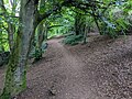
Hubbard's Hills is an area of natural beauty directly to the west of Louth, Lincolnshire, England and is popular for family picnics, school field trips and dog walking. The park is dedicated to the memory of Annie Pahud.

Contents

Topographical geomorphology

Hubbard's Hills is a glacial overspill channel formed as the last ice age ended about 40,000 years ago. A marginal lake of meltwater trapped between glacial ice sheet and the Lincolnshire Wolds poured over a chalk ridge and gouged a 125-foot-deep (38 m), steep-sided valley. The river Lud, far too small to create such a valley, now meanders through it. [1] [2]

History

Memorial to Annie Pahud at Hubbard's Hills Pahud memorial Hubbard's Hills.jpg
Memorial to Annie Pahud at Hubbard's Hills

Hubbard's Hills was donated to the town of Louth by the trustees of Auguste Alphonse Pahud, and opened to the public on 1 August 1907. [3] Auguste Pahud, who was Swiss, moved to Louth in 1875 to take up duties as a German and French teacher at King Edward VI Grammar School. He married a local girl, Annie, daughter of William and Maria Grant. They were wealthy farmers living at the manor in Withern about six miles south east of Louth. [3]

Annie Pahud died in 1889 and Auguste never got over this, committing suicide in 1902. [4] They were buried at Withern Church, but their gravestones were removed after it was declared redundant in July 1980. [5] The church was sold as a private residence in 1983. [5] Annie and Auguste's gravestones are still visible on the pathway beside what used to be the church.

The trustees of Auguste Pahud bought Hubbard's Hills to honour his wish to create a memorial for Annie. [4] They established an Edwardian pleasure garden with a lake, a country park and a memorial. [3] The conveyance required "the natural beauty of the property and its rural character is to be forever maintained".

Following initial discussions in 2008, [6] on 1 April 2009, East Lindsey District Council passed the responsibility to maintain the park to Hubbard's Hills Trust Limited. The Hills will however still “belong” to the people of Louth and the Town Council will continue as official custodians. The Trust's role will be to deliver on a conservation plan to safeguard the next 100 years of the Hills, replanting trees, enhancing the chalk stream and dredging the ornamental lake. Volunteers assisted with clean-up efforts in August, 2009. [4]

Related Research Articles

<span class="mw-page-title-main">Lincolnshire</span> County of England

Lincolnshire is a ceremonial county straddling the East Midlands and Yorkshire and the Humber regions of England. It borders the East Riding of Yorkshire across the Humber estuary to the north, the North Sea to the east, Norfolk, Cambridgeshire, Northamptonshire and Rutland to the south, and Leicestershire, Nottinghamshire and South Yorkshire to the west. The county town is Lincoln.

<span class="mw-page-title-main">North Thoresby</span> Village and civil parish in the East Lindsey district of Lincolnshire, England

North Thoresby is a village and civil parish in the East Lindsey district of Lincolnshire, England. It is situated between Louth and Grimsby, approximately 7.5 miles (12 km) from each. and has a village population of 1,068 (2011) Some 50.5% of the population is older than 60 years.

<span class="mw-page-title-main">Louth, Lincolnshire</span> Market town and civil parish in Lincolnshire, England

Louth is a market town and civil parish in the East Lindsey district of Lincolnshire, England. Louth serves as an important town for a large rural area of eastern Lincolnshire. Visitor attractions include St James' Church, Hubbard's Hills, the market, many independent retailers and Lincolnshire's last remaining cattle market.

<span class="mw-page-title-main">East Lindsey</span> Non-metropolitan district in England

East Lindsey is a local government district in Lincolnshire, England. The population of the district council was 142,300 at the 2021 census. The council is based in Horncastle having moved from its former headquarters at Manby in December 2022. Other major settlements in the district include Alford, Wragby, Spilsby, Holton le Clay, Mablethorpe, Skegness, Horncastle, Chapel St Leonards, Louth and Woodhall Spa. Skegness is the largest town in East Lindsey, followed by Louth.

<span class="mw-page-title-main">Lincolnshire Wolds Railway</span>

The Lincolnshire Wolds Railway (LWR) is a heritage railway based at Ludborough station, near Louth, Lincolnshire, England and the only standard gauge steam railway in Lincolnshire open to the public. The line is part of the original Great Northern Railway (GNR), a rail system that opened in 1848 and once linked Grimsby, Louth and East Lincolnshire with London. In early 2002, 2009 and 2013 the Lincolnshire Wolds Railway received a top national award from the Heritage Railway Association for its heritage railway efforts.

<span class="mw-page-title-main">Lincolnshire Wolds</span> Hill range in Lincolnshire

The Lincolnshire Wolds are a range of low hills in the county of Lincolnshire, England which run roughly parallel with the North Sea coast, from the Humber Estuary in the north-west to the edge of the Lincolnshire Fens in the south-east. They are a designated Area of Outstanding Natural Beauty (AONB), and the highest area of land in eastern England between Yorkshire and Kent.

<span class="mw-page-title-main">Wold Newton, Lincolnshire</span> Village and civil parish in North East Lincolnshire, England

Wold Newton is a village and civil parish in North East Lincolnshire, England. It is situated just over 1 mile (1.6 km) west from the A18 road, 7 miles (11 km) north-west from Louth, and 9.5 miles (15 km) north-east from Market Rasen.

The ceremonial county of Lincolnshire is the second largest of the English counties and one that is predominantly agricultural in character. Despite its relatively large physical area, it has a comparatively small population. The unusually low population density that arises gives the county a very different character from the much more densely populated an urbanised counties of south-east and northern England, and is, in many ways, key to understanding the nature of the county.

<span class="mw-page-title-main">Cleethorpes (UK Parliament constituency)</span> Parliamentary constituency in the United Kingdom

Cleethorpes is a constituency created in 1997, represented in the House of Commons of the UK Parliament since 2010 by Martin Vickers of the Conservative Party.

<span class="mw-page-title-main">Louth and Horncastle (UK Parliament constituency)</span> Parliamentary constituency in the United Kingdom, 1997 onwards

Louth and Horncastle is a constituency in Lincolnshire represented in the House of Commons of the UK Parliament since 2015 by Victoria Atkins, a Conservative.

<span class="mw-page-title-main">Waltham Windmill</span>

Waltham Windmill is a six-sailed windmill located in the village of Waltham, five miles from Grimsby in North East Lincolnshire, England. It is renowned in the area for having all six sails still in full working capacity, being one of the very few windmills like this in the United Kingdom.

<span class="mw-page-title-main">A158 road</span> Road in England

The A158 road is a major route that heads from Lincoln in the west to Skegness on the east coast. The road is located entirely in the county of Lincolnshire and is single carriageway for almost its entirety. The road is approximately 40 miles (64 km) long. The road gets quite congested with holiday traffic during the summer.

<span class="mw-page-title-main">Utterby Halt railway station</span> Former railway station in Lincolnshire, England

Utterby Halt was a railway halt on the East Lincolnshire Railway which served the village of Utterby in Lincolnshire between 1905 and 1961. The station, which opened as part of a new motor train service between Grimsby Town and Louth, is reputed to be haunted by the ghost of a ganger killed on the level crossing in 1953. The line through Utterby remained open for freight until December 1980.

<span class="mw-page-title-main">Withern</span> Village in Lincolnshire, England

Withern is a village in the civil parish of Withern with Stain, in the East Lindsey district of Lincolnshire, England. It is situated on the A157 road, and 7 miles (11 km) south-east from Louth. Stain was once an independent parish but was combined with Withern when the old church of St John the Baptist was destroyed some centuries ago.

<span class="mw-page-title-main">Grainsby Halt railway station</span> Former railway station in Lincolnshire, England

Grainsby Halt was a railway halt on the East Lincolnshire Railway which served the hamlet of Grainsby in Lincolnshire between 1905 and 1952. The station, which opened as part of a new motor train service between Grimsby and Louth, was opened to serve a Victorian hall situated 2 miles (3.2 km) to the west. The station, one of the smallest to be taken over by British Railways on nationalisation in 1947, never really justified its existence and closed in 1952 following a period of temporary closure during the Second World War. The line through Grainsby remained open for freight until December 1980.

Hainton Street Halt was a railway halt on the East Lincolnshire Railway which served the Welholme Road area of Grimsby in Lincolnshire between 1905 and 1961. The station was opened as part of a new motor train service between Grimsby and Louth. The station briefly closed in 1939 as a Second World War economy measure, but reopened in 1940. The line through Hainton Street remained open for freight until December 1980. The trackbed was later reused by Humberside County Council to construct the A16 Peaks Parkway which now runs through the site. Building of the road put an end to the aspirations of the Great Northern and East Lincolnshire Railway plc to reopen the line as a heritage railway.

<span class="mw-page-title-main">River Rase</span> River in Lincolnshire, England

The River Rase is 16 mile (25 km) long tributary of the River Ancholme that flows through Lincolnshire, in the east of England.

<span class="mw-page-title-main">1920 Louth flood</span> Natural disaster (flood)

The 1920 Louth flood was a severe flash flooding event in the Lincolnshire market town of Louth which occurred 29 May 1920, resulting in 23 fatalities in 20 minutes. It has been described as one of the most significant flood disasters in Britain and Ireland during the 20th century.

<span class="mw-page-title-main">David Robinson (journalist)</span>

David Norman Robinson was a British journalist, author, and teacher.

References

  1. "Nature". Hubbard's Hills Trust. Archived from the original on 2013-12-02. Retrieved 2013-11-22.
  2. Robinson, David (2000). "Geomorphology of the Lincolnshire Wolds: an excursion guide" (PDF). Mercian Geologist. 15 (1): 41–48. Retrieved 2013-11-23.
  3. 1 2 3 "History of Hubbard's Hills". Hubbard's Hills Trust. Archived from the original on 2013-12-02. Retrieved 2013-11-22.
  4. 1 2 3 "Cleaning up Pahud memorial". The Grimsby Telegraph. 2009-08-22. Retrieved 2013-11-22.
  5. 1 2 "BYGONES: Village church now a house". The Grimsby Telegraph. 2011-12-02. Retrieved 2013-11-22.
  6. "Council welcomes Hubbards Hills plans". This Is Lincolnshire. 2008-10-28. Retrieved 2013-11-22.

53°21.61′N0°1.46′W / 53.36017°N 0.02433°W / 53.36017; -0.02433