
A suburb is an area within a metropolitan area which has a higher or lower population density and sometimes less detached housing. In many metropolitan areas suburbs rise in population during the day and are where most jobs are located; being major commercial and job hubs, many suburbs also exist as separate residential communities within commuting distance of a larger city. Suburbs can have their own political or legal jurisdiction, especially in the United States, but this is not always the case, especially in the United Kingdom, where most suburbs are located within the administrative boundaries of cities. In most English-speaking countries, suburban areas are defined in contrast to central city or inner city areas, but in Australian English and South African English, suburb has become largely synonymous with what is called a "neighborhood" in the U.S., but it is used in contrast with inner city areas.

In urban planning, zoning is a method in which a municipality or other tier of government divides land into "zones", each of which has a set of regulations for new development that differs from other zones. Zones may be defined for a single use, they may combine several compatible activities by use, or in the case of form-based zoning, the differing regulations may govern the density, size and shape of allowed buildings whatever their use. The planning rules for each zone determine whether planning permission for a given development may be granted. Zoning may specify a variety of outright and conditional uses of land. It may indicate the size and dimensions of lots that land may be subdivided into, or the form and scale of buildings. These guidelines are set in order to guide urban growth and development.

Morden is a district and town in south London, England, within the London Borough of Merton, in the ceremonial county of Greater London. It adjoins Merton Park and Wimbledon to the north, Mitcham to the east, Sutton to the south and Worcester Park to the west, and is around 8 miles (13 km) south-southwest of Charing Cross. Prior to the creation of Greater London in 1965, for local government purposes, Morden was in the administrative and historic county of Surrey.

Urban renewal is a program of land redevelopment often used to address urban decay in cities. Urban renewal involves the clearing out of blighted areas in inner cities to clear out slums and create opportunities for higher class housing, businesses, and other developments. In the United States the term technically refers only to a federal program in the middle-to-late 20th Century, but colloquially is sometimes used to refer to any large-scale change in urban development.

A model village is a type of mostly self-contained community, built from the late 18th century onwards by landowners and business magnates to house their workers. Although the villages are located close to the workplace, they are generally physically separated from them and often consist of relatively high-quality housing, with integrated community amenities and attractive physical environments. "Model" is used in the sense of an ideal to which other developments could aspire.
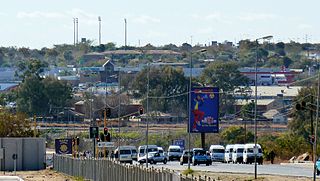
Hammanskraal is a trans-provincial region anchored in northern Gauteng Province, South Africa. The region consists of multiple, residential, industrial and commercial areas in a decentralized settlement pattern.

Suburbanization (AE), or suburbanisation (BE), is a population shift from historic core cities or rural areas into suburbs, resulting in the formation of (sub)urban sprawl. As a consequence of the movement of households and businesses away from city centers, low-density, peripheral urban areas grow.

Redevelopment is any new construction on a site that has pre-existing uses. It represents a process of land development uses to revitalize the physical, economic and social fabric of urban space.

Gleadless is a suburb and parish within the City of Sheffield, it lies five km south east of the city centre. It is bordered by the adjoining suburbs of Gleadless Valley to the west, Frecheville to the east and Intake to the north. The land to the south is the rural area of North East Derbyshire district which is outside the city boundary. Gleadless was formerly a country hamlet, then village before becoming part of the expanding city of Sheffield in 1921. The word Gleadless comes from the Old English language and means either "forest clearings haunted by a kite" or "bright clearing".

Hackenthorpe is a village 5 miles south east of Sheffield’s city centre, now classed as a historic township of the city. Due to much expansion, the village became a part of Sheffield city during the 1950s. During much of the late 19th and 20th centuries the village was noted for its steelmaking, with the Thomas Staniforth & Co Sickle works being based at Main Street. Another prominent feature of the village is the 17th century Hackenthorpe Hall, built by John Newbould for the Hounsfield family, with James Hounsfield being a prominent land owner. The building is today used as a nursery.
Euxton is a village and civil parish of the Borough of Chorley, in Lancashire, England. The population of the civil parish as taken at the 2011 census was 9,993, however, the population is now estimated to be around 14,000 due to the increase in housing developments in the village, including the Buckshaw development. The village is situated just to the west of Chorley, and to the south of Clayton-le-Woods.

South Normanton is a village and civil parish in the Bolsover District of Derbyshire, England. The population at the 2011 Census was 9,445. An ex-mining village, it is two miles east of Alfreton. The historic industries of the village were agriculture, stocking, spinning and mining. Normanton means 'the farm of the north men' or 'Northwegans'.

Llanmartin is a village and parish in the city of Newport, Wales.
Underwood is a settlement in the city of Newport, South East Wales. It is an early 1960s council housing estate that consists of houses, shops, a leisure centre, Baptist church and social club called "Iscoed Tavern" owned by the company red dragon pubs. There is a community centre which has a gym attached to it. The leisure centre is now up for sale.

Shenley is a village and civil parish in Hertfordshire, England, between Barnet and St Albans. The village is located 14 miles from Central London. As of 2021, the population of the parish was 5,390; however, the parish stretches far beyond the village itself; it is the largest parish in Hertsmere and is very rural, including hamlets and farming settlements such as Dancers Hill, Green Street, Kitts End, Ridge, Saffron Green, Shenleybury, and the largest other settlement, South Mimms.

Mixed use is a type of urban development, urban design, urban planning and/or a zoning classification that blends multiple uses, such as residential, commercial, cultural, institutional, or entertainment, into one space, where those functions are to some degree physically and functionally integrated, and that provides pedestrian connections. Mixed-use development may be applied to a single building, a block or neighborhood, or in zoning policy across an entire city or other administrative unit. These projects may be completed by a private developer, (quasi-) governmental agency, or a combination thereof. A mixed-use development may be a new construction, reuse of an existing building or brownfield site, or a combination.

Moulsecoomb is a suburb of Brighton, Sussex, England, on the northeast side around the A270 Lewes Road, between Coldean and Bevendean, 2+1⁄4 miles (3.6 km) north of the seafront. The eastern edge adjoins Falmer Hill on the South Downs. It is often divided into smaller sections on maps: North Moulsecoomb, East Moulsecoomb and South Moulsecoomb.

Brymbo is a village and community in Wrexham County Borough, Wales. It lies in the hilly country to the west of Wrexham city, largely surrounded by farmland.
Conservation development, also known as conservation design, is a controlled-growth land use development that adopts the principle for allowing limited sustainable development while protecting the area's natural environmental features in perpetuity, including preserving open space landscape and vista, protecting farmland or natural habitats for wildlife, and maintaining the character of rural communities. A conservation development is usually defined as a project that dedicates a minimum of 50 percent of the total development parcel as open space. The management and ownership of the land are often formed by the partnership between private land owners, land-use conservation organizations and local government. It is a growing trend in many parts of the country, particularly in the Western United States. In the Eastern United States, conservation design has been promoted by some state and local governments as a technique to help preserve water quality.
One-off housing is a term used in Ireland to refer to the building of individual rural houses, outside of towns and villages. The term is used to contrast with housing developments where multiple units are constructed as part of a housing estate or city street. Less commonly, the term is used to refer to infill housing in suburban areas.