Huerta Real

Last updated
Huerta Real, Spain
village
Country Spain
Province Granada
Municipality Benamaurel
Elevation 680 m (2,230 ft)
Population (2011)
  Total 120
Time zone CET (UTC+1)
  Summer (DST) CEST (UTC+2)

Huerta Real is a village located in the Benamaurel municipality, province of Granada, Spain. According to the 2011 census (INE), the city has a population of 120 inhabitants.

Benamaurel village in Granada, Spain

Benamaurel is a village located in the province of Granada, Spain. According to the 2006 census (INE), the city has a population of 2328 inhabitants. The municipality includes the following localities: Puente Arriba, San Marcos, Cuevas de la Blanca, Huerta Real, Cuevas del Negro y Cuevas de Luna. There is a market held every Sunday morning and a 3-day Moors and Christians festival held in April.

Census Acquiring and recording information about the members of a given population

A census is the procedure of systematically acquiring and recording information about the members of a given population. The term is used mostly in connection with national population and housing censuses; other common censuses include agriculture, business, and traffic censuses. The United Nations defines the essential features of population and housing censuses as "individual enumeration, universality within a defined territory, simultaneity and defined periodicity", and recommends that population censuses be taken at least every 10 years. United Nations recommendations also cover census topics to be collected, official definitions, classifications and other useful information to co-ordinate international practice.

Instituto Nacional de Estadística (Spain) Spains principal government institution in charge of statistics and census data

The National Statistics Institute is the official agency in Spain that collects statistics about demography, economy, and Spanish society. It is an autonomous organization in Spain responsible for overall coordination of statistical services of the General State Administration in monitoring, control and supervision of technical procedures. Every 10 years, this organisation conducts a national census. The last census took place in 2011.

Huerta Real with Jabalcon mountain behind. Panoramica Huerta Real.jpg
Huerta Real with Jabalcón mountain behind.

It is located by the Guardal River, where Baza and Cúllar rivers join it. Most inhabitants live in cave houses.

Related Research Articles

Glasgow, Delaware CDP in Delaware, United States

Glasgow is a census-designated place (CDP) in New Castle County, Delaware, United States. The population was 14,303 at the 2010 census.

Salisbury, Nassau County, New York Hamlet and census-designated place in New York, United States

Salisbury is a hamlet and census-designated place (CDP) in Nassau County, New York, United States. The population was 12,093 at the 2010 census. Many Levitt style homes lie adjacent to Eisenhower Park, formerly Salisbury Park. Salisbury is located in the Town of Hempstead, but located in the Westbury postal zone, served by the Westbury Railroad Station of the Long Island Railroad, shares fire districts with Westbury and East Meadow, and is within the East Meadow School District.

Saluda, Virginia county seat in Virginia

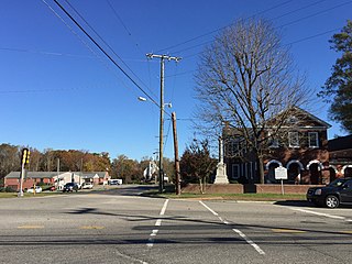
Saluda is a census-designated place (CDP) in and the county seat of Middlesex County, Virginia, United States. The population as of the 2010 Census was 769.

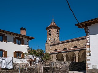
Anue is a town and municipality located in the province and autonomous community of Navarre, northern Spain.

Arellano is a town and municipality located in the province and autonomous community of Navarre, northern Spain.

Mués is a town and municipality located in the province and autonomous community of Navarre, northern Spain.

Golden Ring Hotel is a five-star hotel in Moscow. The hotel is located just opposite the Ministry of Foreign Affairs Building and the Arbat Street, on Smolenskaya Ulitsa. The hotel was built in 1970 as the Belgrade-I Hotel and used to serve foreign tourists who visited Russia with Intourist groups. Since 1991 the Golden Ring Hotel is a member of the hotel chain affiliated to the Department of Affairs of the President of the Russian Federation.

Flat is an unincorporated community in southern Phelps County, Missouri, United States. It is located approximately sixteen miles southwest of Rolla. The community is at the intersection of Missouri routes M and T. Edgar Springs lies about four miles to the southeast at the intersection of route M and U.S. Route 63. The headwaters of Mill Creek are just to the east of the community. The village lies within the boundaries of the Mark Twain National Forest.

Gray County Wind Farm near Montezuma, Kansas is the largest wind farm in Kansas and the largest in the United States not mandated by a state regulatory commission. The site consists of 170 Vestas V-47 wind turbines with a total nameplate capacity of 112 MW. Each turbine tower is 217 feet high, with blades 77 feet long, and a generating capacity of 660 kW. Owned and operated by NextEra Energy Resources, Gray County Wind Farm became fully operational in November 2001. Its construction cost an estimated $100 million. The average wind speed at the site is approximately 20 mph. The area is primarily used for farmland.

Spring Creek Township, Pike County, Illinois Township in Illinois, United States

Spring Creek Township is located in Pike County, Illinois. As of the 2010 census, its population was 591 and it contained 295 housing units.

Gilbuena Place in Castile and León, Spain

Gilbuena is a municipality located in the province of Ávila, Castile and León, Spain. According to the 2004 census (INE), the municipality has a population of 99 inhabitants.

Ponto dos Volantes human settlement in Brazil

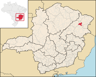
Ponto dos Volantes is a Brazilian municipality located in the northeast of the state of Minas Gerais. The city belongs to the mesoregion of Jequitinhonha and to the microregion of Araçuaí. As of 2007 the population was 10,976 in an area of 1,215 km². The elevation is 400 meters. It became a municipality in 1997. The postal code (CEP) is 39615-000.

Rue is an unincorporated community in Accomack County, Virginia.

Hampstead is an unincorporated community in New Kent County, Virginia, United States.

Opegoi, California Former settlement in California, United States

Opegoi is a former Karok settlement in Humboldt County, California. It was located on the Klamath River opposite the mouth of Red Cap Creek, at an elevation of 341 feet.

Central Garage is a census-designated place (CDP) in King William County, Virginia, United States. The population as of the 2010 Census was 1,318.

Chestnut Grove, Buckingham County is an unincorporated community in Buckingham County, in the U.S. state of Virginia.

Key Center is a census-designated place (CDP) in Pierce County, Washington, United States. The population was 3,692 at the 2010 census. In 2016, the population grew to 3,810. The community is located on Key Peninsula.

Gore Island, or Isla Gore, is an island in the Colorado River Delta within the state of Baja California, Mexico. It lies between two dis-tributary channels east of the main channel of the Colorado River and Montague Island that flow southeastward into the Gulf of California, southeast of the mainland of Baja California Peninsula.

Umpire is an unincorporated community in southwestern Wright County, in the U.S. state of Missouri.

References

Coordinates: 37°36′22″N2°44′43″W / 37.60611°N 2.74528°W / 37.60611; -2.74528

Geographic coordinate system Coordinate system

A geographic coordinate system is a coordinate system that enables every location on Earth to be specified by a set of numbers, letters or symbols. The coordinates are often chosen such that one of the numbers represents a vertical position and two or three of the numbers represent a horizontal position; alternatively, a geographic position may be expressed in a combined three-dimensional Cartesian vector. A common choice of coordinates is latitude, longitude and elevation. To specify a location on a plane requires a map projection.