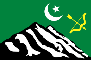
Hunza, also known as Kanjut, was a principality and then later a princely state in a subsidiary alliance with British India from 1892 to August 1947, for three months was unaligned, and then from November 1947 until 1974 was a princely state of Pakistan. Hunza covered territory now forming the northernmost part of Gilgit-Baltistan, Pakistan.
Hopper or hoppers may refer to:

Gilgit is the capital city of Gilgit–Baltistan, Pakistan. The city is located in a broad valley near the confluence of the Gilgit River and the Hunza River. It is a major tourist destination in Pakistan, serving as a hub for trekking and mountaineering expeditions in the Karakoram mountain range.
Gojal, also called Upper Hunza, is situated in northwestern Pakistan. It borders China at the Khunjerab Pass, and Afghanistan at the Chapursan valley. In 2019, Gojal Valley became the second Karachukar sub-ivision within the Hunza District. It is geographically the largest subdivision of Gilgit-Baltistan.

Wakhi is an Indo-European language in the Eastern Iranian branch of the language family spoken today in Wakhan District, Northern Afghanistan and also in Tajikistan, Northern Pakistan and China.
The Wakhi people, also locally referred to as the Wokhik, are an Iranian ethnic group native to Central and South Asia. They are found in Afghanistan, Tajikistan, Pakistan and China—primarily situated in and around Afghanistan's Wakhan Corridor, the northernmost part of Pakistan's Gilgit−Baltistan and Chitral, Tajikistan's Gorno−Badakhshan Autonomous Region and the southwestern areas of China's Xinjiang Uyghur Autonomous Region. The Wakhi people are native speakers of the Wakhi language, an Eastern Iranian language.

The Karakoram Highway is a 1,300 km (810 mi) national highway which extends from Hasan Abdal in the Punjab province of Pakistan to the Khunjerab Pass in Gilgit-Baltistan, where it crosses into China and becomes China National Highway 314. The highway connects the Pakistani provinces of Punjab and Khyber Pakhtunkhwa plus Gilgit-Baltistan with China's Xinjiang Uyghur Autonomous Region. The highway is a popular tourist attraction and is one of the highest paved roads in the world, passing through the Karakoram mountain range, at 36°51′00″N75°25′40″E at maximum elevation of 4,714 m (15,466 ft) near Khunjerab Pass. Due to its high elevation and the difficult conditions under which it was constructed, it is often referred to as the Eighth Wonder of the World. The highway is also a part of the Asian Highway AH4.

Shimshal is a village located in Gojal Tehsil of Hunza District, in the Gilgit–Baltistan region of Pakistan. It lies at an altitude of 3,113 metres (10,213 ft) above sea level and is the highest settlement in the district. It is the largest valley in Gilgit-Baltistan and it covers almost area of Hunza District. It is in the valley of the Shimshal River, a tributary of the Hunza River. Shimshal is a border village that connects the Gilgit-Baltistan area of Pakistan with China. The total area of Shimshal is approximately 3,800 km2 (1,500 sq mi) and there are around two thousand inhabitants with a total of 250 households.

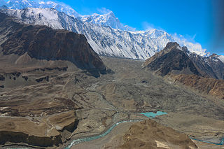
Passu is a small village located in Gojal valley upper Hunza of the Gilgit Baltistan, Pakistan region of Northern Pakistan. Situated along the Karakoram Highway in Upper Hunza, Pakistan, Passu is a popular tourist destination in Pakistan and all over the world because of its easily accessible sweeping landscapes, and vistas of the 7,478 m tall Passu Sar mountain, the Passu Glacier, and Tupopdan 6,106m.

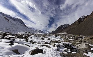
The Trans-Karakoram Tract, also known as the Shaksgam Tract, is an area of approximately 5,200 km2 (2,000 sq mi) north of the Karakoram watershed, including the Shaksgam valley. The tract is administered by China as part of its Taxkorgan and Yecheng counties in the Xinjiang Uyghur Autonomous Region. Although the Shaksgam tract was never under the control of Pakistan since 1947, in the 1963 Sino-Pakistan Agreement, Pakistan recognized Chinese sovereignty over the Shaksgam tract, while China recognized Pakistani sovereignty over the Gilgit Agency, and a border based on actual ground positions was recognized as the international border by China and Pakistan. It is claimed by India as part of the Union territory of Ladakh.

Nagar was a princely salute state in the northern part of Gilgit–Baltistan, Pakistan. Until August 1947, it was in a subsidiary alliance with British India. It bordered the states of the Gilgit Agency to the south and west, and the princely state of District Hunza to the north and east. From November 1947 to 1974 it was a princely state of Pakistan. The state capital was the town of Nagar.
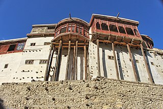
Karimabad, formerly known as Baltit, is the capital of Hunza District, in the Gilgit-Baltistan province of Pakistan. An article on The Guardian ranked it as one of the five "Best Tourist Sites" in Pakistan.

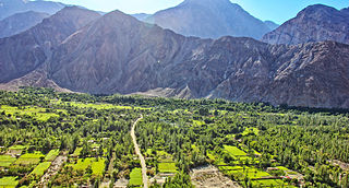
The Hunza Valley is a mountainous valley in the northern part of the Gilgit-Baltistan region of Pakistan, formed by the Hunza River, bordering Ishkoman to the northwest, Shigar to the southeast, Afghanistan's Wakhan Corridor to the north, and the Xinjiang region of China to the northeast.
Nasirabad or Nasir Abad may refer to:
Nalter may refer to various places in Pakistan:
The Hunza–Nagar District is a former district of Gilgit–Baltistan in Pakistan. In July 2015, the district was divided into two separate districts, namely Hunza District and Nagar District.

Oshikhandass is a village in Gilgit-Baltistan. It is east of Gilgit city. Oshikhandass is part of the Bagrot Valley and had approximately 7,200 inhabitants in 2011. Approximately60% of the population belongs to the Shia Isna Ashri Muslims sect of Islam, and 40% are Shia Imamia Ismaili Muslims, that follows the 4th The local economy is primarily agriculture based. There are three government schools, two of which are for girls and one is for boys. In addition there are five private schools. The village altitude is 1,500 metres (4,900 ft).

The Kalasha Valleys are valleys in Chitral District in northern Pakistan. The valleys are surrounded by the Hindu Kush mountain range.
Chapursan is a valley containing approximately eight scattered villages situated within the Hunza District of Gilgit−Baltistan in Pakistan. It is located in the northern part of the country, close to the border with the Wakhan District of Afghanistan and the Xinjiang Uyghur Autonomous Region of China. The valley is predominantly inhabited by ethnic Wakhis; the village of Raminj in this region is inhabited by ethnic Burushos. The valley's inhabitants largely adhere to the Isma'ili sect of Shia Islam. Chapurson hosts over 500 households with an estimated population of 3000 people.
Nomal is a small valley located at a distance of 25 km north of Gilgit city in the Gilgit District, in northern Pakistan. The valley is also connected with Nalter Bala and Nalter Pain through a metaled road.