Hurst Green is a suburb of Halesowen in the Metropolitan Borough of Dudley, located on its north-eastern side. Its principal thoroughfares are Narrow Lane/Fairfield Road, Summerfield Avenue and Hurst Green Road and Woodbury road with a small shopping centre at the eastern end of the latter bordering the M5 motorway. It is a mixture of owner-occupied and municipal housing, the latter concentrated around Brandon Road/Westfield Road. There is an industrial area to its north along Fairfield Road and Cakemore Road.
Halesowen is a large market town in the Metropolitan Borough of Dudley, in the county of West Midlands, England. It is considered as one of the largest towns in the United Kingdom without a railway station.
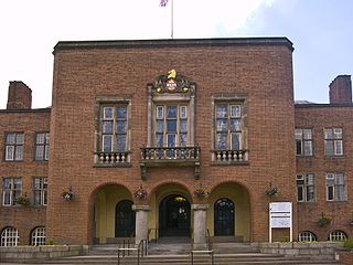
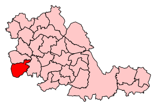
The Metropolitan Borough of Dudley is a metropolitan borough of West Midlands in England. It was created in 1974 following the Local Government Act 1972, through a merger of the existing Dudley County Borough with the municipal boroughs of Stourbridge and Halesowen. The borough borders Sandwell to the east, the city of Birmingham to the south east, Bromsgrove to the south in Worcestershire, South Staffordshire District to the west, and the city of Wolverhampton to the north.
It is served by buses X8, X10, 13A, 14, 19, 202, 231
Although it is administratively part of Halesowen, it is geographically closer to Blackheath, where its residents have traditionally shopped and to where most of its public transport links operate.
Blackheath is a town and ward in the Rowley Regis area of the Sandwell Metropolitan Borough, in the county of West Midlands, England.
A geographic coordinate system is a coordinate system that enables every location on Earth to be specified by a set of numbers, letters or symbols. The coordinates are often chosen such that one of the numbers represents a vertical position and two or three of the numbers represent a horizontal position; alternatively, a geographic position may be expressed in a combined three-dimensional Cartesian vector. A common choice of coordinates is latitude, longitude and elevation. To specify a location on a plane requires a map projection.
Related Research Articles
The A458 is a route on the UK highway network that runs from Mallwyd, near Machynlleth, in Wales, to Halesowen, near Stourbridge, in England. On the way it passes through Welshpool, Shrewsbury, Much Wenlock, Bridgnorth and Stourbridge.
Halesowen and Rowley Regis is a constituency in the West Midlands represented in the House of Commons of the UK Parliament since 2010 by James Morris, a Conservative.
Stourbridge is a constituency represented in the House of Commons of the UK Parliament since 2010 by Margot James, an independent MP, formerly a Conservative.
Known as the Hagley Road in Birmingham, the A456 is a main road in England running between Central Birmingham and Woofferton, Shropshire, south of Ludlow. Some sections of the route, for example Edgbaston near Bearwood, are also the route of the Elan Aqueduct which carries Birmingham's water supply from the Elan Valley.
The A563 is the designation for the ring road of Leicester, England. It forms a near complete circuit except for a gap of around 2.2 miles (3.5 km) in the east of the city. An indirect route linking the gap involves the (A47) A6030, and A6. The A563 was formerly referred to as the Outer Ring.
Causeway United Football Club was a football club based in Halesowen, England, but originally from Oldbury.
Halesowen Abbey was an abbey in Halesowen, England of which only ruins remain. It was located in an exclave of the historic county of Shropshire until 1844. In that year Halesowen was transferred to Worcestershire and then in 1974 to the new West Midlands county.
Netherton is an area of the Metropolitan Borough of Dudley, 1.5 miles (2 km) south of Dudley town centre in the West Midlands of England, but historically in Worcestershire. In the Black Country, Netherton is bordered by nature reserves to the east and west, and an industrial area and the Dudley Southern By-Pass to the north.
Old Hill railway station is in Old Hill, West Midlands, England, on the Birmingham-Stourbridge line. It is managed by West Midlands Trains, who provide the majority of train services; Chiltern Railways also operate a small number.
Watley's End was a small village located in South Gloucestershire, England. It now forms the northern part of Winterbourne. Watley's End Road, which runs through the village, would have been the main road.
The A491 is an A road in Zone 4 of the Great Britain numbering scheme.
Lapal is a residential area of Halesowen in the West Midlands of England. It is situated in the east of the town on the border with Birmingham. The Lapal area sits to the East of the Lapal Canal, to the North of Lapal Lane South up to what is now the M5 motorway, to the South West of Carters Lane and Kent Road, and to the South East of Mucklow Hill. Most of the houses were built between 1930 and 1980. In the late 1970s the large Abbeyfields estate was built alongside the currently disused portion of the Dudley Canal, adding to its already extensive owner-occupier housing stock.
Haden Hill is a residential area in the West Midlands of England, straddling the border of Halesowen and Cradley Heath townships and the modern boroughs of Dudley and Sandwell.
Squirrels Estate is a residential area of Halesowen in the West Midlands conurbation of England. It is situated approximately two miles south-west of the town centre, bordering onto countryside in the direction of Kidderminster. It is located in the Hayley Green & Cradley South ward of Dudley Metropolitan Borough.
For the area in London of the same name, see Bell Green, London
Lutley is an area of Halesowen in the West Midlands, England. Site of a mill, called the Lutley Mill, also the name of a local Pub. Lutley Mill is situated on Puddings Brook. The Lutley Gutter runs through Lutley.
Hayley Green is a suburb of Halesowen in the Metropolitan Borough of Dudley, West Midlands, England, located to the south-west of Halesowen town centre. Its focal points are the Fox Hunt public house run by the Harvester restaurant chain and a row of small shops on the A456/B4183 roundabout. It has mainly owner-occupied housing stock, including the Causey Farm estate, St Kenelms Avenue and Squirrels estate, with a small 1940s municipal housing estate off Uffmoor Lane.
Halesowen bus station is a bus station in the town of Halesowen in the West Midlands conurbation in England. It is owned and managed by Transport for West Midlands.
This article details a number of defunct schools that were once located in the Metropolitan Borough of Dudley. For details of currently operating schools in the area, please see: List of schools in Dudley.
This page is based on this Wikipedia article Text is available under the CC BY-SA 4.0 license; additional terms may apply. Images, videos and audio are available under their respective licenses.