
Goslar is a district in Lower Saxony, Germany. It is bounded by the districts of Göttingen, Northeim, Hildesheim and Wolfenbüttel, the city of Salzgitter, and by the states of Saxony-Anhalt and Thuringia (Nordhausen).

Osterode was a district in Lower Saxony, Germany. It was bounded by the districts of Göttingen, Northeim and Goslar, and by the state of Thuringia.
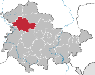
Unstrut-Hainich-Kreis is a Kreis (district) in the north of Thuringia, Germany. Neighboring districts are the districts Eichsfeld, Kyffhäuserkreis, Sömmerda, Gotha, Wartburgkreis and the district Werra-Meißner in Hesse.

Neustadt (Aisch)-Bad Windsheim is a Landkreis (district) in Bavaria, Germany. It is bounded by the districts of Würzburg, Kitzingen, Bamberg, Erlangen-Höchstadt, Fürth and Ansbach, and by the state of Baden-Württemberg.
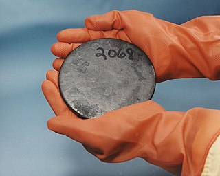
Uranium-235 (235U) is an isotope of uranium making up about 0.72% of natural uranium. Unlike the predominant isotope uranium-238, it is fissile, i.e., it can sustain a fission chain reaction. It is the only fissile isotope with a primordial nuclide found in significant quantity in nature.

Jürgen Schult is a German former track and field athlete and as of 2018, the world record holder in the discus throw. Holding the title since 1986, it is the longest standing record in men's track and field. Schult represented East Germany in the 1988 Olympic competition in the discus throw on 1 October 1988, when he won the gold medal.
Mansfelder Grund-Helbra is a Verbandsgemeinde in the Mansfeld-Südharz district, in Saxony-Anhalt, Germany. Before 1 January 2010, it was a Verwaltungsgemeinschaft. It is situated between Eisleben and Mansfeld. The seat of the Verbandsgemeinde is in Helbra.

Rerik is a town in the Rostock district, in Mecklenburg-Western Pomerania, Germany. It is situated on the Baltic Sea coast, 19 km west of Bad Doberan, and 27 km northeast of Wismar. In 1938, Rerik was named after the old Slavic settlement Reric, that was believed to have been situated near present Rerik.

Marl-Chemiepark Power Station is an ensemble of three thermal power stations. One of these power stations has a 300 meters tall, another a 241 meters tall chimney.
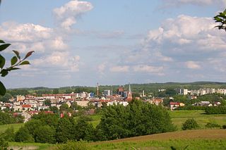
Połczyn-Zdrój is a town in Świdwin County, West Pomeranian Voivodeship, Poland, with 11,153 inhabitants (2007).

Advanced Landing Grounds (ALGs) were temporary advance airfields constructed by the Allies during World War II during the liberation of Europe. They were built in the UK prior to the invasion and thereafter in northwest Europe from 6 June 1944 to V-E Day, 7 May 1945.
Bad Tennstedt is a Verwaltungsgemeinschaft in the district of Unstrut-Hainich-Kreis in Thuringia, Germany. The seat of the Verwaltungsgemeinschaft is in Bad Tennstedt.

Hohsaas is a cable car station and a ski area in the Pennine Alps above Saas Grund in Valais.

Zawada is a village in the administrative district of Gmina Kożuchów, within Nowa Sól County, Lubusz Voivodeship, in western Poland. It lies approximately 7 kilometres (4 mi) south-east of Kożuchów, 11 km (7 mi) south of Nowa Sól, and 28 km (17 mi) south-east of Zielona Góra.

Germany is a country in west-central Europe, that stretches from the Alps, across the North European Plain to the North Sea and the Baltic Sea. Germany has the second largest population in Europe and is seventh largest in area. The territory of Germany covers 357,021 km2 (137,847 sq mi), consisting of 349,223 km2 (134,836 sq mi) of land and 7,798 km2 (3,011 sq mi) of waters.

The WeltWald Harz up to 2009 Arboretum Bad Grund, also known as Exotenwald and sometimes called the Arboretum des Forstamtes Grund or the Forstaboretum der Niedersächsischen Landesforstverwaltung, is an arboretum located along the B 242 federal highway near the Hübichenstein, northwest of Bad Grund, Lower Saxony, Germany. It is open daily without charge.

The Iberg is a hill, 563 m above sea level, in the western Harz mountains in the German state of Lower Saxony.
The Gittelde–Grund railway, also known as Kleinbahn Gittelde-Grund, was a railway line connecting the mining town of Grund at the western edge of the Harz mountains with the station of Gittelde on the Herzberg–Seesen railway. It opened in 1910 and closed in 1971.

Cueva Antón is a paleoanthropological and archeological site in the Region of Murcia of southeast Spain. The cave is located about 60 kilometers from the Mediterranean port city of Cartagena inland in the territory of the municipality of Mula. It was eroded by the Río Mula and served as a cave in the Middle Palaeolithic inhabited by Neanderthals. The cave became internationally known in 2010, after a shell at least 43,000 years old with adhering orange pigment was discovered there. The pigment found was interpreted as evidence that the shell was used "in an aesthetic and probably symbolic" way. The find from the Cueva Antón was published together with similar finds from the Cueva de los Aviones; they were named as the first such Neanderthal jewelry found in Europe. The colonization of the Iberian Peninsula by modern man took place only several thousand years after the creation of the jewelry from the Cueva Antón. This site is the last known place where Neanderthal people resided.


