
A glacier is a persistent body of dense ice that is constantly moving under its own weight. A glacier forms where the accumulation of snow exceeds its ablation over many years, often centuries. It acquires distinguishing features, such as crevasses and seracs, as it slowly flows and deforms under stresses induced by its weight. As it moves, it abrades rock and debris from its substrate to create landforms such as cirques, moraines, or fjords. Although a glacier may flow into a body of water, it forms only on land and is distinct from the much thinner sea ice and lake ice that form on the surface of bodies of water.
Indian or Indians may refer to something or someone of, from, or associated with the nation of India or with the indigenous people of the Americas.

The Barents Sea is a marginal sea of the Arctic Ocean, located off the northern coasts of Norway and Russia and divided between Norwegian and Russian territorial waters. It was known earlier among Russians as the Northern Sea, Pomorsky Sea or Murman Sea ; the current name of the sea is after the historical Dutch navigator Willem Barentsz.

The climate of Antarctica is the coldest on Earth. The continent is also extremely dry, averaging 166 mm (6.5 in) of precipitation per year. Snow rarely melts on most parts of the continent, and, after being compressed, becomes the glacier ice that makes up the ice sheet. Weather fronts rarely penetrate far into the continent, because of the katabatic winds. Most of Antarctica has an ice-cap climate with extremely cold and dry weather.
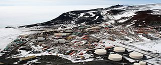
McMurdo Station is an American Antarctic research station on the south tip of Ross Island, which is in the New Zealand-claimed Ross Dependency on the shore of McMurdo Sound in Antarctica. It is operated by the United States through the United States Antarctic Program (USAP), a branch of the National Science Foundation. The station is the largest community in Antarctica, capable of supporting up to 1,500 residents, and serves as one of three year-round United States Antarctic science facilities. All personnel and cargo going to or coming from Amundsen–Scott South Pole Station first pass through McMurdo. McMurdo Station continues to operate as the hub for American activities on the Antarctic continent. By road, McMurdo is 3 kilometres (1.9 mi) from New Zealand's smaller Scott Base.

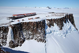
Halley Research Station is a research facility in Antarctica on the Brunt Ice Shelf operated by the British Antarctic Survey (BAS). The base was established in 1956 to study the Earth's atmosphere. Measurements from Halley led to the discovery of the ozone hole in 1985. The current base is the sixth in a line of structures and includes design elements intended to overcome the challenge of building on a floating ice shelf without being buried and crushed by snow. As of 2020, the base has been left unstaffed through winter since 2017, due to concerns over the propagation of an ice crack and how this might cut off the evacuation route in an emergency.

Pituffik Space Base, formerly Thule Air Base, is the United States Space Force's northernmost base, and the northernmost installation of the U.S. Armed Forces, located 750 mi (1,210 km) north of the Arctic Circle and 947 mi (1,524 km) from the North Pole on the northwest coast of the island of Greenland. Pituffik's Arctic environment includes icebergs in North Star Bay, two islands, a polar ice sheet, and Wolstenholme Fjord – the only place on Earth where four active glaciers join together. The base is home to a substantial portion of the global network of missile warning sensors of Space Delta 4, and space surveillance and space control sensors of Space Delta 2, providing space awareness and advanced missile detection capabilities to North American Aerospace Defense Command (NORAD), the United States Space Force, and joint partners.
Bleed air is compressed air taken from the compressor stage of a gas turbine, upstream of its fuel-burning sections. Automatic air supply and cabin pressure controller (ASCPC) valves bleed air from low or high stage engine compressor sections; low stage air is used during high power setting operation, and high stage air is used during descent and other low power setting operations. Bleed air from that system can be utilized for internal cooling of the engine, cross-starting another engine, engine and airframe anti-icing, cabin pressurization, pneumatic actuators, air-driven motors, pressurizing the hydraulic reservoir, and waste and water storage tanks. Some engine maintenance manuals refer to such systems as "customer bleed air".
Magician or The Magician may refer to:

The McMurdo Sound is a sound in Antarctica, known as the southernmost navigable body of water in the world, located approximately 1,300 kilometres (810 mi) from the South Pole.
Aris or ARIS may refer to:

A drifting ice station is a temporary or semi-permanent facility built on an ice floe. During the Cold War the Soviet Union and the United States maintained a number of stations in the Arctic Ocean on floes such as Fletcher's Ice Island for research and espionage, the latter of which were often little more than quickly constructed shacks. Extracting personnel from these stations proved difficult and in the case of the United States, employed early versions of the Fulton surface-to-air recovery system.

On 21 January 1968, an aircraft accident, sometimes known as the Thule affair or Thule accident, involving a United States Air Force (USAF) B-52 bomber occurred near Thule Air Base in the Danish territory of Greenland. The aircraft was carrying four B28FI thermonuclear bombs on a Cold War "Chrome Dome" alert mission over Baffin Bay when a cabin fire forced the crew to abandon the aircraft before they could carry out an emergency landing at Thule Air Base. Six crew members ejected safely, but one who did not have an ejection seat was killed while trying to bail out. The bomber crashed onto sea ice in North Star Bay, Greenland, causing the conventional explosives aboard to detonate and the nuclear payload to rupture and disperse, resulting in radioactive contamination of the area.
SANAE IV is a current South African Antarctic research base located in Vesleskarvet, Queen Maud Land. The base is part of the South African National Antarctic Program (SANAP) and is operated by the South African National Antarctic Expedition.

Antarctica is Earth's southernmost and least-populated continent. Situated almost entirely south of the Antarctic Circle and surrounded by the Southern Ocean, it contains the geographic South Pole. Antarctica is the fifth-largest continent, being about 40% larger than Europe, and has an area of 14,200,000 km2 (5,500,000 sq mi). Most of Antarctica is covered by the Antarctic ice sheet, with an average thickness of 1.9 km (1.2 mi).

Korolev is an ice-filled impact crater in the Mare Boreum quadrangle of Mars, located at 73° north latitude and 165° east longitude. It is 81.4 kilometres (50.6 mi) in diameter and contains about 2,200 cubic kilometres (530 cu mi) of water ice, comparable in volume to Great Bear Lake in northern Canada. The crater was named after Sergei Korolev (1907–1966), the head Soviet rocket engineer and designer during the Space Race in the 1950s and 1960s.

East Base on Stonington Island is the oldest American research station in Antarctica, having been commissioned by Franklin D. Roosevelt in 1939. The station was built as part of two US wintering expeditions – United States Antarctic Service Expedition (1939–1941) and Ronne Antarctic Research Expedition (1947–1948). The base covers 1,000 metres (3,300 ft) from north to south and 500 metres (1,600 ft) from east to west. The base was accorded the status of one of the Historic Sites and Monuments in Antarctica on 7 May 2004.
