
Klæbu is a municipality in Trøndelag county, Norway. It is located in the southern part of the Trondheim Region, about 20 kilometres (12 mi) south of the city of Trondheim. The administrative center is the village of Klæbu. The other major village in Klæbu municipality is Tanem.

Tydal is a municipality in Trøndelag county, Norway. The administrative centre of the municipality is the village of Ås. Other villages include Østby, Gressli, Aunet, and Stugudalen. There is a school and a kindergarten in Tydal.
Meråker is a municipality in Trøndelag county, Norway. It is part of the Stjørdalen region. The administrative centre of the municipality is the village of Midtbygda which is about 20 kilometres (12 mi) west of Storlien in Sweden and 46 kilometres (29 mi) east of the town of Stjørdalshalsen in neighboring Stjørdal municipality. Other villages in Meråker include Gudåa, Kopperå, and Stordalen.

Skarvan and Roltdalen National Park is a national park in Trøndelag county, Norway. The park is located in the municipalities of Selbu, Tydal, Meråker, and Stjørdal, not too far from the border with Sweden to the east.

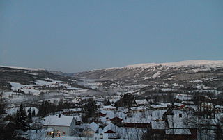
Mebonden or Mebond is the administrative centre of the municipality of Selbu in Trøndelag county, Norway. It is located at the eastern end of the lake Selbusjøen at the mouth of the Nea River. The villages of Vikvarvet, Hyttbakken, Innbygda, and Trøa surround the urban village of Mebonden. The 12th century Selbu Church is located in Mebonden.

Selbusjø or Selbusjøen is the 17th largest lake in Norway. It is located in Trøndelag county, primarily in the municipality of Selbu, although the western end of it lies in the neighboring municipality of Klæbu. The 58.26-square-kilometre (22.49 sq mi) lake is the largest lake in the southern part of Trøndelag county. Selbusjø is part of the Nea-Nidelv watershed, with the Nea River flowing into it on the eastern end and the Nidelva River flowing out the western end. The deepest part of the lake reaches 206 metres (676 ft) below the surface. The villages of Selbustrand, Fossan, Tømra, Trøa, Innbygda, Mebonden, Vikvarvet, and Sjøbygda lie around the lake.
Sørungen is a lake in the municipality of Selbu in Trøndelag county, Norway. The 7.24-square-kilometre (2.80 sq mi) lake is located about 8 kilometres (5.0 mi) south of the village of Vikvarvet, about 18 kilometres (11 mi) west of the village of Flora, and about 10 kilometres (6.2 mi) northeast of the lake Samsjøen in the neighboring municipality of Midtre Gauldal.
Rotla is a 40-kilometre (25 mi) long river in Trøndelag county, Norway. The river begins at Roltdalstjønna in Meråker municipality, just north of the mountain Fongen. It then runs through west through the Skarvan and Roltdalen National Park. The river ends when it flows into the Nea River near Stokkan in Selbu municipality. The Nea River then flows west for 15 kilometres (9.3 mi) until reaching the lake Selbusjøen at the village of Mebonden. The river Rotla is part of the Nea-Nidelvvassdraget watershed.

Fongen (Norwegian) or Lopmesvaerie (Southern Sami) is a mountain in Trøndelag county, Norway. The mountain sits along the border of the municipalities of Selbu, Tydal, and Meråker. The 1,441-metre (4,728 ft) summit is located inside the Skarvan and Roltdalen National Park. The nearest villages are Mebonden in Selbu, about 25 kilometres (16 mi) to the southwest, Ås in Tydal, about 32 kilometres (20 mi) to the southeast, and the village of Midtbygda in Meråker. The closest Norwegian Trekking Association cabin is Ramsjøhytta, several kilometers to the east of the summit.
Nea (Norwegian), Ganka (Southern Sami), or Nean (Swedish) is an 80-kilometre (50 mi) long river which has runs through the municipalities of Tydal and Selbu in Trøndelag county, Norway and Åre Municipality in Jämtland county, Sweden. The river Nea is a part of the Nea-Nidelvvassdraget watershed. Some of the main villages along the river include: Østby, Ås, Aunet, and Gressli in Tydal and Flora, Hyttbakken, Selbu, and Mebonden in Selbu.
Trøa is a village in the municipality of Selbu in Trøndelag county, Norway. It is located along the eastern end of the lake Selbusjøen, just north of the village of Innbygda, about 5 kilometres (3.1 mi) north of the municipal center of Mebonden, and about 4 kilometres (2.5 mi) south of the village of Tømra.
Flora is a village in the municipality of Selbu in Trøndelag county, Norway. It is located along the Nea River, about 25 kilometres (16 mi) southeast of the municipal center of Mebonden and about 10 kilometres (6.2 mi) northwest of the village of Gressli in the neighboring municipality of Tydal. The Flora Chapel is located in this village.
Fossan is a village in the municipality of Selbu in Trøndelag county, Norway. It is located about 5 kilometres (3.1 mi) north of the municipal center of Mebonden, across the lake Selbusjøen. Fossan is located about halfway between the villages of Selbustrand and Tømra.
Hyttbakken is a village in the municipality of Selbu in Trøndelag county, Norway. It is located along the Nea River, about 6.5 kilometres (4.0 mi) east of the municipal center of Mebonden and about 15 kilometres (9.3 mi) northwest of the village of Flora.
Vikvarvet is a village in the municipality of Selbu in Trøndelag county, Norway. It is located on the southern shore of the lake Selbusjøen, about 4 kilometres (2.5 mi) southwest of the municipal center of Mebonden.
Selbustrand is a village in the municipality of Selbu in Trøndelag county, Norway. It is located about 5 kilometres (3.1 mi) across the lake Selbusjøen from the municipal center of Mebonden. The village of Fossan lies about 3 kilometres (1.9 mi) to the northeast of Selbustrand. The Selbustrand Church is located in this village.
Selbustrand Church is a parish church in Selbu municipality in Trøndelag county, Norway. It is located in the village of Selbustrand. It is the church for the Selbu parish which is part of the Stjørdal prosti (deanery) in the Diocese of Nidaros. The white, wooden church was built in a long church style in 1901 by the architect O. Alfstad. The church seats about 300 people.
Flora Chapel is a parish church in Selbu municipality in Trøndelag county, Norway. It is located in the village of Flora. It is a church in the Selbu parish which is part of the Stjørdal prosti (deanery) in the Diocese of Nidaros. The red, wooden church was built in a long church style in 1936 by the architects Anton Kjelstad and Ivar Grylland. The church seats about 140 people.
Sneisen is a village in the municipality of Malvik in Trøndelag county, Norway. It is located in the Mostadmarka area in the southern part of the municipality, about 10 kilometres (6.2 mi) south of the village of Hommelvik and 12 kilometres (7.5 mi) north of the village of Selbustrand. Mostadmark Chapel is located in the village.


